Showing posts with label Scotland. Show all posts

Thursday, June 29, 2023

If this is Thursday it must be postcards, 613


Bannockburn, Stirling, Scotland


A “Hail Caledonia” product published by Whiteholme Ltd of Dundee, Scotland, this unused card has a photograph of the statue of Robert the Bruce, King of the Scots, 1306-1329.  The statue was unveiled by Queen Elizabeth II on 24 June 1964, to commemorate the 650th anniversary of the Battle of Bannockburn in 1314.  The title and number 21984 are found at the bottom margin of the card.


South of the city of Stirling in Scotland is the town of Bannockburn.  It was named after the stream, or burn, that runs through the town and flows into the River Forth.  The area is especially known for being the site of one the pivotal battles fought during the Wars of Independence between the kingdoms of Scotland and England in the 13th and 14th centuries.


The massive bronze figure of King Robert I of Scotland is set upon a white granite plinth.  The king is dressed in light armor, holding his battle-axe, and astride his horse.  In 1964 the statue was commissioned by the Earl of Elgin.  Pilkington Jackson was the sculptor.  He used the measurements from Bruce’s skull that had been rediscovered at Dunfermline Abbey in 1818.  It is believed that King Robert I was probably about 6 ft 1” or 185 cm. tall as a young man.  At his written request, after he died, his heart was removed and buried at Melrose Abbey in Roxburghshire. 


The bronze statue was covered in a green patina so it was restored in 2013 in preparation for the 700th anniversary of the Battle of Bannockburn in 2014.


Also at this site is the Rotunda, Memorial Cairn, and Flagpole.  Sir Robert Matthew is responsible for the overall concept, with H.C. Clark designing the landscape scheme, and F.R. Stevenson as project architect for the buildings.  The Rotunda is a circular enclosure of concrete-block topped by a timber rail.  Massive, rough boulders at the entrance blend the natural and artificial landscape.  Openings at two places the visitor is provided with a view similar to that of the advancing army of Edward II. 


For additional information, see:


https://en.wikipedia.org/wiki/Robert_the_Bruce


https://en.wikipedia.org/wiki/Bannockburn


https://en.wikipedia.org/wiki/Equestrian_statue_of_Robert_the_Bruce,_Bannockburn


This last link is supposed to be on one line but it was too long.  It will need to be copied and pasted into a browser search field:


https://commons.wikimedia.org/wiki/Category:Bannockburn,_Rotunda,_Memorial_Cairn,_Flagpole_And_Statue_Of_King_Robert_I


Thursday, October 29, 2020

If this is Thursday it must be postcards, 475


Near Pitfure Church, Rogart, East Sutherland, Scotland, ca 1950s

Today’s used postcard, published by Anne Baxter, Golspie & Train, features an image by Photo Precision Ltd., St. Ives, Cambs.  The number R7711 is printed at the bottom center on the reverse.  This is another card that was found in a shoebox of mixed cards in an antique mall.  

The country scene is appealing and includes a little patch of heather, lower right corner.  Heather is one of the traditional flowers of Scotland but it also grows in the mountains in the Pacific Northwest.  The road winding through the valley of Strathfleet leads to Lairg a village in the Highlands.  While most of the settlements in the Highlands are along the coast, Lairg is inland.  It used to be known as the Crossroads of the North from the four roads that meet in the village.  

Rogart is a small village in the Highlands that was the home of Major Andrew MacDonald.  MacDonald is known to have fought in the French and Indian War.  The Rogart railway station opened in 1886 and allowed the village to expand around the older village.

Open-air preaching was traditional before 1900 when there was a division in the United Free Church.  In 1929 most of the United Free Church joined the Church of Scotland but there were still some bad feelings and the congregations remained separate until around 1948 when they were officially united into one congregation.  

One story regarding the church building was that in the old days prior to the split, the site for the building was refused by McLeod, the land owner.  McLeod claimed as “Lord of the soil and therefore entitled to prevent God’s creatures from enjoying that soil for any purpose which he does not approve.  He will let it out for culture, and give houses in which to eat and drink and sleep, but not a spot on which to build a house of God, to worship.”  Prior the building of the church, the community asked if they could meet on the beach above the high-water mark.  The answer was that they could put up a tent and meet there for worship.  Between 1900 and the completion of the building members met in local homes and sometimes in the open-air.  In 1906 fundraising was started to build a new church at Pitfure.  The project was completed in 1910.  Robert J. MacBeth of Inverness was the architect.  At the jubilee celebration in 1960 an open-air meeting was held behind the church just as the sun was setting over the hills.


The stamp shows a profile view of Queen Elizabeth with the Lion of Scotland at the upper left.  This design with various values was printed for use in Scotland in the 1950s.  


For additional information, see:

https://en.wikipedia.org/wiki/Rogart
https://en.wikipedia.org/wiki/Lairg
https://en.wikipedia.org/wiki/Battle_of_Skibo_and_Strafleet
https://rogartheritage.co.uk/places/pitfure-church
 

Thursday, June 22, 2017

If this is Thursday it must be postcards, 304


Hotel and Beach, John O'Groats, Scotland

This real photo postcard shows the hotel and beach at John O’Groats Scotland.  It is unused, has the code 8.2 at the lower right corner and includes a children’s rhyme: “Rainy, Rainy, Rattlestanes, Dinna rain on me.  Rain on John O’Groats House Far across the Sea.”  Very like the children's rhyme "Rain, rain go away, come again another day."  I think rattlestanes are hailstones.

In 1903 the Kodak Company introduced a Folding Pocket Kodak camera that would take pictures the same dimensions as a standard postcard of the time, approximately 3 ½ “ X 5 ½ “.  The photos cold then be printed on postcard backs and mailed.  By 1907 Kodak had introduced the postcard service called “real photo postcards” to make a postcard from any picture.  It seems like a very clever idea.  Several other companies also used the term “real photo” from about 1903 to around 1930.  Many of the real photo postcards record area events, show homes, prominent citizens, summer picnics, parades, and disasters such as fires and floods.  The photo cards were also used for commercial purposes like real estate listings or souvenirs.  The reverse side of this card has the notation:  “The Tea Room, John O’Groats,” suggesting that it was a souvenir from the hotel and purchased during a visit to the Tea Room. 

The village of about 300 residents is located about 4 km or 2.5 miles northeast of Canisbay, Cathness, in the far north of Scotland.  I wondered why it was called John O’Groats and discovered that it was named after a Dutchman named John de Groot who settled there in 1489 with his brothers.  He ran a ferry service from the Scottish mainland to Orkney.  Some people say the name comes from the fee of one groat that John de Groot was said to have charged passengers.  A groat was a silver coin no longer used that was worth four English pennies or a Scottish fourpence.  The English silver groats were first minted during the reign of Edward I of England in 1272-1307.  Scottish groats were issued during the time of David II, 1367-1371.  The value of the Scottish groat went from fourpence to eightpence and a shilling.  Ireland also minted groats first in 1425 and the last ones during the time of Elizabeth I.  Groats continued to be used in some British territories until the decimal system was adopted in 1955.  Even though the fare is no longer a groat there is still a passenger ferry that goes from John O’Groats to Burwick on South Ronaldsay in Orkney.  The Gaelic version of Groot is Ghròt making it much more likely that the village is named for the man not for the fee.

John O’Groats receives large numbers of tourists each year.  The Hotel shown on the postcard above was built in 1875 on or near the site of the de Groot house.  The following trivia comes from Haydn’s Dictionary of Dates:  The original house was octagon shape with one room, 8 windows and 8 doors to admit 8 members of the family as a means to prevent quarrels for precedence at the table.  Each family head had his own door and sat at an octagon table, which did not have a head of the table. 

There is a famous “Journey’s End” signpost where people could take photos.  At one time there was a fee to have a photo taken with the sign but today the fee has been done away with and the old sign has been replaced with a more permanent sign.

For additional information, see:

http://www.electricscotland.com/culture/features/scots/poetry6.htm
https://en.wikipedia.org/wiki/Groat_(coin)
https://en.wikipedia.org/wiki/John_o%27_Groats
https://en.wikipedia.org/wiki/Real_photo_postcard

Thursday, June 30, 2016

If this is Thursday it must be postcards, 253


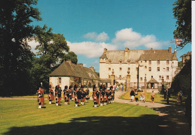
Traquair House, Peepleshire, Innerleithen, Scotland
[Front view of Traquair House, CKTH10, printed and published by Jarrold & Sons Ltd., Norwich]

The set of postcards shared this week come from the travel card collection sent by Jim and Kelsey.  The card above shows the oldest continually inhabited house in Scotland, Traquair House.  It was built on the site of an old hunting seat, used by Scottish Kings as early as the 12th century, but this fortified manor house is probably not that old. 

When the peace of the Border region was threatened after the death of Axeander III in 1286, Traquair House became an important key in the defense of the Tweed Valley against English invasion.  Ownership changed often, sometimes under control of the English and at other times the Scottish throne.  James Stuart (1480-1513) the illegitimate son of the Earl of Buchan inherited the estate in 1491.  Stuart later obtained letters of legitimization and married the heiress of the Rutherfords and by so doing received the estates of Rutherford and Wells in Roxburghshire.  Traquair House was the family seat of the Earls of Traquair for four centuries.  In 1875 it passed to a cousin of the Stuarts, Henry Constable Maxwell, a direct descendant on the female side.  The current laird of Traquair is Catherine Maxwell Stuart.  


Front of Traquair House with the Peebles Ex-Servicemens' Pipe Band
[photo:  Joan Gibson, Pilgrim Press Ltd., Derby, #17549B]

How big is this house?  There are 50 rooms including a Drawing room with ancestral portraits, a dressing room decorated to show what life was like in former times; a Museum room containing a mural dated from 1530; the King’s room where Mary, Queen of Scots stayed in 1566; the Still Room where breakfast was served; the Dining room, added in the 17th century; a chapel built in 1829; and a library containing more than 3,000 books. 


Traquair House Library 
[TH 6, printed & published by Jarrold & Sons, Ltd., Norwich]

The fifth Earl, Charles Stuart, installed the bear gates at the main entrance in 1738.  The gates were closed in 1745 after the Scottish rebellion and the Earl vowed they would never open again until a Stuart king returned.  

The following anonymous poem is printed on the card reverse:  

"Dool an' sorrow hae fa'en Traquair, 
  An' the Yetts that were shut at Charlie's comin' 
He vowed wad be opened nevermair, 
  Till a Stuart King was crooned in Lunnon.

"Gone are the Stuarts o' auld Trquair,
  Green is the Avenue rank an' hoary,
And the Bears look doon wi' an angert glare,
  On the "Steekit Yetts" an' the vanished glory."


Bear Gates
[PPL/84463/X, printed in Great Britain by J. Arthur Dixon]

Trivia:  There is a recently planted maze in the gardens.  An annual fair is held on the first weekend in August.  Ale was brewed at Traquair during the reign of Mary Queen of Scots and in 1739 a 200-gallon copper vat was installed in the brew house located under the chapel.  In 1965 Peter Maxwell Stuart started the Traquair House Brewery using 18th century domestic brewery equipment that had once been used to make beer for the house.  Best known for the two main brands, Jacobite Ale and House Ale, the brewery also makes a range of other beers. 

For additional interesting details, see:

https://en.wikipedia.org/wiki/Traquair_House

Thursday, June 16, 2016

If this is Thursday it must be postcards, 251


 Culloden Batterfield, Inverness, Scotland

This postcard above is of the Culloden Battlefield, Inverness, Scotland printed by J. Arthur Dixon and shows the Memorial Cairn (top left), the Old Leanach Cottage—battle museum (top right), The interior of the cottage (bottom left) and the burial ground of the clansmen (bottom right).  The number on the reverse of the card is PIN/84695.  The site is in the care of the National Trust for Scotland. 

The second postcard shown below is a closer view of the interior of the cottage museum.  Credit for the photo is given to Precision Limited of St. Ives, Huntington and Colourmaster International printed it.  There are two numbers on the reverse of the card—NS 639 at the mid top and PT36895 at the mid bottom. 


Interior of Leanach Cottage, Culloden

The 1745 Jacobite uprising to over throw the Hanoverian George I and restore the House of Stuart by putting Charles Stuart, known as “Bonnie Prince Charlie,” on the British throne was halted by defeat in a short battle at Culloden in 1746.  Approximately 1,500 to 2,000 Scottish Jacobites were killed or wounded in the brief 1-hour Highlander charge and battle that occurred here.  The British government lost 50 dead and had 259 wounded.  Even today strong feelings about the battle and its aftermath continue with many modern commentators alleging that the penalties inflicted on the Scots were brutal.  Attempts were made to integrate the “wild” Highlands into the Kingdom of Great Britain, civil penalties were introduced to weaken the Gaelic culture and attack the Scottish clan system. 

The final battle was held near where the small Leanach cottage shown on the cards stands today.  This cottage dates from 1760 and is located on the site where the original turf cottage used as a field hospital for government troops during and after the battle is thought to have stood.  

Duncan Forbes, a descendant of Duncan Forbes, Lord of Culloden, had the memorial cairn erected at Culloden in 1881.  The cairn is 20 feet or 6.1 meters tall and is perhaps the most recognizable feature of the battlefield today.  That same year he had headstones erected to mark the mass graves of the clans.  Forbes also had another stone placed to mark the spot where Alexander McGillivray of Dunmaglass was found after the battle.  McGillvray fell while leading his clan and followers into the battle.  The location of about sixty government soldiers is unknown but may be located in the future since directly under a spot where a coin was found there appears to be a large burial pit.  It is thought that a soldier may have dropped the coin when he came to visit the graves of his fallen comrades. 

During the last 16 years or so there has been archeological, topographical, geophysical and metal detector surveys conducted at Culloden battlefield.  So far where the fiercest fighting occurred pistol balls and shattered muskets have been uncovered and it is hoped that more items of interest will be uncovered as time goes on. 


For more detailed information about the Jacobite uprising and Culloden check out these sites:

https://en.wikipedia.org/wiki/Battle_of_Culloden
http://www.cullodenhouse.co.uk/about-us-history
https://en.wikipedia.org/wiki/Duncan_Forbes,_Lord_Culloden
https://en.wikipedia.org/wiki/Clan_MacGillivray

Thursday, March 31, 2016

If this is Thursday it must be postcards, 240


Blair Castle, exterior view

My nephew’s bride and her father know that I collect postcards and very kindly sent me a huge stack of travel cards that had been gathered by another relative who had since passed away.  The batch they sent included these three of Blair Castle, Perthshire, Scotland. 

Blair Castle is the ancestral home of Clan Murray and is located in Glen Garry, commanding a strategic position on the main route through the central Highlands.  Legend has it that a neighbor started building the castle on the Earl of Atoll’s land in 1269 while the Earl was away on crusade.  When he returned the Earl complained about the interloper to King Alexander III and won back his land.  He then proceeded to incorporate the new tower into his own castle.  David II Strathbogie, Earl of Atholl forfeited the lands and title, in 1322 for rebellion against Robert the Bruce.  The earldom was then transferred to a half brother, John Stewart (1440-1512).  In 1629 John Murray was created Earl of Atholl and the title has since remained with the Murray family.  Blair Castle was taken over by Oliver Cromwell’s army in 1650 but later restored to the Murrays by Charles II.   The current Duke, Bruce Murray, lives in South Africa not in Blair Castle.


Blair Castle Ballroom

As with many old castles this one has been added to and renovated several times during the centuries.  The last main remodel was the addition of a new ballroom in 1885.  The castle has been open to the public since 1936 and contains displays of weapons, trophies, paintings and furniture among other things collected by the Murray family over many generations.  There is also a garrison for the Atholl Highlanders, the only legal private army in Europe.  The grounds appear in the national listing of significant gardens found in the Inventory of Gardens and Designed Landscapes in Scotland.  


Knight in armor


Many thanks and appreciation to Kelsey & Jim for thinking of me and sending the postcards.

For more information, see:

https://en.wikipedia.org/wiki/Blair_Castle

Thursday, July 23, 2015

If this is Thursday it must be postcards, 204


 Castle Sinclair, Caithness, Scotland

The color picture postcard above shows the remains of Castle Sinclair also called Castle Girnigoe located in Caithness, Scotland.  Caithness is in the north of Scotland with this castle, one of the earliest seats of Clan Sinclair, about 3 miles north of Wick on the east coast.  Our line of McKays or MacKay, as it was in Scotland, also came from Caithness and lived in the northern coastal town of Thurso hence I was particularly taken with this card.  The postcard is a "Hail Caledonia" product published by Whiteholme Ltd. of Dundee.

Castles usually seem to have interesting histories and this one is no exception.  William Sinclair, the 2nd Earl of Caithness, who died at the battle of Flodden in 1513, had the castle built sometime between 1476 and 1496 possibly on the ruins of an earlier structure.  Almost 65 years later in 1577 John, Master of Caithness, held his father the 4th Earl, George Sinclair, prisoner in the castle for seven years where he eventually died.  In 1606 the building was extended to include a gatehouse and other buildings that were surrounded by a curtain wall with a drawbridge spanning a rock-cut ravine.   Following the expansion the then Earl obtained permission from Parliament to change the name from Girnigoe to Castle Sinclair; although, both names remain in use.  As part of the renovation a small secret chamber was constructed in the vaulted ceiling of the kitchen with a rock-cut stairway down to the sea, and a well was built in the lowest level of the tower.  Many castles and manor houses had "priest-holes" or secret hiding places where a priest or some other person could hide in time of need. About this same time escape routes were also often built. 

The castle remained with the Sinclairs until 1676 when the Earl’s widow remarried John Campbell of Glen Orchy who claimed the title Earl and the castle.  George Sinclair of Keiss, who claimed rightful inheritance, stormed the castle in 1679 resulting in the Battle of Altimarlech (1680).  The Campbells were victorious.  In 1690 George Sinclair again besieged the castle.  It was thought that the castle sustained severe damage from cannon fire during that siege but the story has been discounted.  Nevertheless the castle became a ruined shell and until recently it was allowed to fall in decay.  Today the Clan Sinclair Trust has begun restoration work in an attempt to preserve the importance of the building.  Once work is complete it will become one of the few castles open to the public and accessible to handicapped people. 

For addition historical information, see:

https://en.wikipedia.org/wiki/Castle_Sinclair_Girnigoe

https://en.wikipedia.org/wiki/Priest_hole