Showing posts with label Ohio. Show all posts

Thursday, May 22, 2014

If this is Thursday it must be postcards, 143


Fort Harmar, Marietta, Ohio

While in Marietta, Ohio earlier this year we crossed the bridge to what was originally Harmar where this early fort stood.  Today this is part of the town of Marietta.  The postcard is another in a series published by David Shelburne-Shelburne Films for the historical documentary “Opening the Door West”  and available at the Campus Martius Museum in Marietta.

Fort Harmar was built in 1785 by John Doughty (1754-1826).  He was the American military officer who also oversaw the construction of Fort Washington in 1789 on the Ohio frontier.   Fort Harmar was shaped like a pentagon and was situated at the confluence of the Ohio and Muskingham rivers directly across from the Picketed Point Fort featured in a previous postcard Thursday.  The fort was abandoned and later demolished as the development of Marietta expanded.  In 1789 it was the site of the Treaty of Fort Harmar between the United States and several Native American tribes. 

The fort took its name from Josiah Harmar who was influential in the founding of Marietta and had been one of the officers at Fort Harmar.  Even though the village of Harmar has been annexed into the town of Marietta it is still referred to as Harmar and is listed on the National Register of Historic Places.

The footbridge across the river for pedestrians and bicyclers was built next to the rail bridge that is no longer used. The footbridge was interesting because while certainly sturdy enough it is not level nor straight.  Growing near the shoreline and partly in the river were several Silver Maples that can be partially seen at the right side of the photo below. 


Wiggly footbridge 


Sign by the Harmar rail bridge


Harmar historic buildings


Sign by the Masonic lodge in Harmar


Looking across the river from Harmar to Marietta.

For more information:

http://en.wikipedia.org/wiki/John_Doughty
http://en.wikipedia.org/wiki/Fort_Harmar
http://www.OpeningTheDoorWest.com

Thursday, April 17, 2014

If this is Thursday it must be postcards, 138


Castle in the Hills, near Newcastle, Ohio

Eli Nichols built the house shown on this week’s postcard in the 1840s.  The secluded stone house in the Buckeye forest was used as an Underground Railroad station for escaping slaves before the Civil War.  Nichols, who was born in Virginia and moved to Ohio with his family when he was a child, was raised as a Quaker but as an adult left the Society of Friends and became interested in spiritualism.  He was an eminent attorney, politician, legislator and an abolitionist who helped many escaping slaves to make their way across Ohio toward Canada in the years before the Civil War.

The Underground Railroad was not a railroad in the usual sense but a series of foot routes where escaping slaves could find safe houses or safe places to hide as they continued traveling north.  People who helped in this effort used railroad terminology as codes.  A shepherd or agent would help slaves find the railroad, guides were known as conductors, hiding places were stations.  The slaves were known as passengers or cargo.  Ohio had numerous routes as seen on the map below from Wikipedia.  Most of the slaves that Nichols helped came from eastern Tennessee and Kentucky. 


There is folklore associated with the Underground Railroad including stories about quilts hung on fences or clothes lines pointing the way to sanctuaries.  One book I read several years ago describes a particular patchwork quilt pattern called the Log Cabin that had black central squares and was used as a sign to escapees that this was a safe route or a safe place to stop.  Another quilt theory points to ten different patterns with one quilt at a time placed on a fence as a way of non-verbal communication or alerts to runaways.  The code was supposed to have had two meanings, one to signal runaway slaves to prepare to flee, the second to give clues and directions for the journey.  Both quilt historians and scholars of pre-Civil War America, however, have disputed these theories, so there is currently no evidence to substantiate this folklore. 

Music or songs such as spirituals like “Steal Away” and “Follow the Drinking Gourd,” were once thought to contain coded messages to assist individuals using the railroad.  The Drinking Gourd had reference to the North Star and Big Dipper.  Scholars who point out that slaves songs certainly expressed hope but did not contain literal help for runaways disbelieve this popular folklore.  One song, however, written in 1860 to the tune of “Oh, Susanna” and called “Song of the Free” is about a man fleeing slavery in Tennessee has stanzas that end with references to Canada.  Canada had abolished slavery in 1834 and was the destination of most escapees.

Trivia:  in some cases the Underground Railroad operated in reverse as fugitives returned to the United States from Canada
following the passage of the 13th Amendment to the United States Constitution outlawing slavery by Congress in 1865.
 
D, F. Anguish Enterprises, Dresden, Ohio published the postcard and Dexter Press, Inc. of  West Nyack, New York printed the cards.  It has a divided back with an information blurb at the top of the message side and an identifying number at the lower left corner:  47823-B.  The information provided on the card says that Fulton Van Voorhis owned the estate at the time the card was published.  Van Voorhis and his heirs owned it from 1921 to 1969.  It is not a Linen card but appears to be from about 1940; however, it is difficult to date it since it unused and does not have a cancellation mark that might have helped.  It almost looks as if the picture may have been a black & white photograph that has been tinted then reproduced as a color card.

For more information about Eli Nichols and the Underground Railway, see

http://www.ohiohistorycentral.org/w/Eli_Nichols
http://en.wikipedia.org/wiki/Underground_Railroad
http://rea-williams.com/getperson.php?personID=I2192&tree=tree1

Thursday, April 3, 2014

If this is Thursday it must be postcards, 136


Picketed Point Stockade, Marietta, Ohio, ca 1791


The postcard above shows another of the forts built in the Marietta, Ohio area by the Ohio Company of Associates as protection for settlers during the Indian Wars of 1791-1795.   The image on this card is one of a series published by David Shelburne-Shelburne Films from an award-winning documentary entitled “Opening the Door West.”  The red building in the forefront of the picture is the “red house tavern” also known as the “Buell and Munsell Hotel.”  Built in 1789 by Joseph Buell and Levi Munsell it was the first frame building in the Northwest Territory. 


Although the fort no longer exists there is a stone marker where it originally stood.  Picketed Point was the last of the fortifications built at Marietta.  It encompassed a space of about four acres with blockhouses and sentry boxes.   The card shows dwelling houses inside the fenced area.  Military quarters were also located within the fort.  The entry gates were wide enough to admit teams such as mules, horses and oxen.  The gates were constructed of thick planks sturdy enough to afford protection for the men on guard.  Like the other forts it also had pickets and palisades as additional protection.


Stone marking the southern boundary of Picketed Point


Note the white barked tree at the front left of the card.  We saw several of these trees on our recent visit to Marietta and did not know what they were.  The lower trunk is a normal brown color while the upper trunk and branches are white or silver colored.  Without leaves it was difficult to guess what these striking trees might be.  We asked at the Campus Martius Museum and found out that they are Silver Maples, a tree that is fast growing and is often found along waterways and wetlands so it is sometimes also called a “water maple.”  It is not found in the northwestern United States but is one of the most common trees in the eastern United States and Canada.


Silver Maple

The magnificent specimen shown above is located in the parkway off Front Street along the Muskingum River in Marietta.  We also saw several of these trees growing along the bank by the Harmar footbridge as well as here and there throughout Marietta.  The original forest surrounding Picketed Point was composed of hardwood trees such as oak, elm, hickory, beech and maple that still grow there although not as abundantly as they did in the 1700s due to early logging and construction.  Most of the evergreen trees we saw were pines and may have been planted by the inhabitants sometime later.  Ohio Buckeye trees can be found almost everywhere also.  They produce a fruit similar to a chestnut in appearance.  The inner nut is said to resemble the eye of a buck, hence the name.  The nuts and shell casings can be found in great numbers on the ground as these native trees were very popular and have been planted along the streets.   Supposedly the first tree felled in the Northwest Territory was a Buckeye. 


For additional information, please see


Sunday, March 30, 2014

Hopewell earthworks -- Marietta Mounds


As mentioned previously, when I travel to Marietta, Ohio I like to take walks and often go through the two main cemeteries, Oak Grove and the Mound Cemetery.  Both have hills but I think only the one at the Mound Cemetery is an actual earthwork.  The Oak Grove Cemetery appears to cover several natural hills.  It is possible to get to the high point in both cemeteries; however, and I did that on this trip.  Last time there was snow on the ground and I wasn’t sure I could get down from the Oak Grove hill without falling, this time it was rainy and wet but Bob helped navigate a safe path and all was well.


Proof that I reached the top of the Oak Grove hill and saw the monument

There are stairs leading up to the top in the Mound Cemetery and it is very peaceful and tranquil up there.  My son and his wife told us that the library is on another mound and nearby was a third mound called Turtle Mound by the locals and used in the winter as a sledding hill. 

Here below are some views of the Conus Mound in the Mound Cemetery.  It rises about 30 feet from the foot to the top, is surrounded by a 15 foot wide, 4 foot deep moat and a berm on the outside of the moat.  From what I read the locality, moat and berm mean that the mound was for ceremonial uses and not a fortification.   It is 585 feet in circumference.


The Great or Conus Mound. 

The staircase and rail are on the left side of the mound.  There are benches and a time capsule on the top.


The time capsule marker


Looking past Commodore Abraham Whipple’s grave toward the Conus Mound and staircase.


Looking from the top down onto the moat and berm that ring the mound.

The Conus Mound was originally a burial mound for the ancient people who lived here and created the mounds.  Today it stands in the center of the Mound Cemetery where many Revolutionary War veterans are buried. 

The mounds are called Hopewell earthworks and we wondered who the Hopewell people were and if more information could be found concerning the mounds and the people who built them.  As it turned out, the name Hopewell came from the European family who owned land where some mounds existed so it does not really apply to the ancient people who built them at all. 

Mounds like these can be found in several states from as far south as Florida to Canada in the north.  There are a number of them in Ohio.  


No one knows for sure who these people were or what happened to their society.  The mounds appear to have been built for specific purposes and are in geometric shapes, rise to impressive heights, and are within a degree or two of seasonal events such as sunrises, moonrises, solstices and equinoxes.  There is some evidence to suggest that there was an extensive trading network throughout the region.  Beautiful and skillful artwork and craft work have been found in some of the graves.


Above is a picture of the library built on the mound called the Capitolium

The other mound we went past several times was the Quadranaou also known as Turtle Mound.


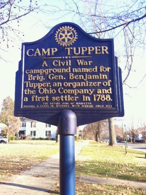
During the Civil War this mound was used as a campground, named after the Revolutionary War Brig. General Benjamin Tupper and therefore has a second marker seen below.   General Tupper is buried in the Mound Cemetery.


Bob found the map below that was prepared in 1838 marking the main earthworks in Marietta.  The early European settlers gave them Latin names:


1.    the Great or Conus Mound, was originally a burial mound, it is the one located in the Mound Cemetery. 
2.    Another of the earthworks was named Sacra Via or the sacred way, a pathway down to the Muskingum River and a large open area that included the Capitolium and the Quadranaou as well as two smaller mounds at the eastern and northern corners. 
3.    The library was built on top of the Capitolium in 1918. 
4.    The Quadranaou is a truncated pyramidal mound with ramps leading to the top.  During the American Civil War it was used as a campground.  It is also the one called Turtle mound.  Research on this mound in the 1990s showed that it was aligned to within two-tenths of one degree with the winter solstice sunset.

All these earthworks are thought to date between 200 BC and 900 AD and could perhaps be older.

For additional information on the mounds and the Hopewell culture see:

http://en.wikipedia.org/wiki/Marietta_Earthworks

http://en.wikipedia.org/wiki/Hopewell_tradition

http://en.wikipedia.org/wiki/Mound_Cemetery_%28Marietta,_Ohio%29

Special thanks to Lou for taking and sending additional pictures of the mounds.  The Sacra Via is the only earthworks on the map that I have not seen in person.  On the next trip to Marietta we hope to visit it. 

Thursday, March 27, 2014

If this is Thursday it must be postcards, 135


The Vincent Gun-shop exhibit, Campus Martius Museum, Marietta, Ohio

One of the exhibits at the Campus Martius Museum in Marietta, Ohio is a replica of the Vincent Gunshop as seen on this postcard published by H.K. Barnett, of Allison Park, Pennsylvania.  The tools and patterns used by this father and son are shown in the photo on the card.  The Vincents were eminent gunsmiths in southeastern Ohio.  I found an article on Google books that appeared originally in the Association of Ohio Long Rifle Collector publication written by William Reynolds, dated I think 1980, that provides interesting information about the Vincents.  The article also included photographs of the men, where they lived and worked and their rifles.  See the link below to access the document.

Here is a synopsis of the material in the article.  John Vincent, the father, was born in 1809 and apprenticed as a cabinetmaker when he was young.  He had a very good business making spinning wheels at his home on Rocky Point and also a farmed a large tract of land.  He did not start making guns until he was 38 years old and joined Aman Ford a gunsmith at Watertown.  Vincent learned enough from Ford to become a very skilled gunsmith. 

Vincent’s son, John Caleb or Caleb as he was called, was born in 1841 and like his father took up the cabinetmaker’s trade at an early age.  He became interested in his father’s gunsmithing work squeezing in time between the farm chores to learn the skills he would need to establish his own business later at Vincent Station.   Vincent Station is located not far from Marietta just off highway 550.  Today the name has been shortened to Vincent.  Rocky Point, where his father lived, is east of Vincent.

These two men made an estimated 300 to 360 guns with perhaps 80 to 90 examples surviving to the present day.  John Vincent was primarily a farmer who manufactured and repaired spinning wheels and guns on the side while his son, Caleb, wished to be a full time gunsmith.  Caleb acquired a property from his uncle Henry Earl Vincent and built his home at Vincent Station.  For a short period of time he had his gunsmith shop in the back of a grocery store then later he built a separate shop.  Although he worked full time at making guns and was more popular as a gunsmith than his father he would not sacrifice quality for speed and only produced between 10 and 15 new guns a year.  He did do a lot of gun repair work as well as making new guns. 

The rifles manufactured by these men have become quite collectible and have for the most part remained in private collections or in the possession of families whose ancestors bought the gun directly from the father or son.  


We visited the Campus Martius Museum in Marietta on the recent trip and took a few photos seen below of the Vincent Gun exhibit.  The museum has several displays ranging from early Ohio and Marietta history, the Civil War, the Appalachian migration into Ohio, and the Rufus Putnam home.  


For more information about John & Caleb Vincent gunsmiths, please see:

http://www.aolrc.org/wordpress/wp-content/uploads/2009/03/vol-ii-no-1-feb-1980.pdf

Thursday, March 20, 2014

If this is Thursday it must be postcards, 134


Return J. Meigs, Jr. home, Marietta, Ohio

One of the things I have enjoyed doing on trips to Marietta, Ohio is looking for the historical markers placed in front of some of the buildings and homes.  This postcard published by Richardson Printing Corporation of Marietta, shows the home of the fourth governor (1810-1814) of Ohio, Return Jonathan Meigs, Jr., and was built in 1802 overlooking the Muskingum River.  The pictures below show the house as it looks today complete with the historical marker.  There are a few minor changes since the postcard was printed such as the removal of window shutters and the balcony railing above the front door.


Return J. Meigs, Jr. was born in Middletown, Connecticut in 1764 a descendant of early Puritan settlers in Massachusetts.  After graduating from Yale University in 1785 where he studied law he was admitted to the Connecticut bar association.  He moved to Marietta, Ohio around 1788 joining his father who was among some of the first settlers in the Northwest Territory. 

Meigs was also the 5th United States Postmaster General from 1814 to 1823 serving under two Presidents, James Madison and James Monroe.  He served as a United States Senator during the years 1808-1810 when he finished out the term of John Smith then resigned when he was elected governor of Ohio in 1810.   In addition to serving in all these public offices he was a lawyer, storekeeper, and farmer. 

In 1788 Meigs married Sophia Wright and they had one daughter.  Although he did not have a direct male heir, two of his brothers each named a son Return Jonathan Meigs.  Return J. Meigs III passed the Kentucky bar and practiced law in Tennessee later becoming prominent in Tennessee state affairs before the Civil War.  He moved to New York when Tennessee seceded from the Union in 1861.  Return J. Meigs IV married Jennie Ross a daughter of the Cherokee chief John Ross and followed the Trail of Tears to Oklahoma.  


Return J. Meigs, Jr. resigned from the Post Office in 1823 due to ill health.  He died in 1825 and is buried in the Mound Cemetery where his grave is marked by this large monument shown in the pictures below.  We stopped at the cemetery on a recent trip to Marietta to get a few pictures.  It took a long time for us to find the grave even though the stone is quite large.  The grave is located in the front left quadrant of the cemetery and is marked on the diagram found in front of the Conus mound and seen in the photo above.  There is engraving on one side of the stone only.  Most of the large stones have the family name prominently displayed but on this one his name is just incorporated into the text.  It was easier to find the nearby graves of Col. Ichabod Nye, Salah Bosworth, and Dudley Woodbridge who were Revolutionary War veterans and had flags by their headstones.  The text is hard to read but I copied it out and include it below the photos.


"Here lies the body of his excellency Return Jonathan Meigs who was born at Middletown, Connecticut Nov. 1766 and died at Marietta March 29, 1825.  For many years his time and talents were devoted to the service of his country.


"He successfully filled the distinguished places of judge of territory, Northwest of the Ohio.  Judge of the Supreme Court of the State of Ohio.  Senator in the Congress of the United States, Governor of the State of Ohio and Postmaster General of the United States.  

"To the honored and revered memory of

An ardent patriot
A practical Statesman
An enlightened scholar
A dutiful son
An indulgent father
An affectionate husband


"This monument is erected by his mourning widow Sophia Meigs."

For more information about Return J. Meigs, please see:

http://en.wikipedia.org/wiki/Return_J._Meigs,_Jr.

Wednesday, March 19, 2014

McDonough Park, Vienna, West Virginia


Map showing the trail system for the park
 
Last year when I went to Marietta, Ohio for a visit the end of February into the first part of March it snowed.  The day we arrived this year it was sunny and 69 degrees F; however, the following day it was freezing.   Yes, it snowed again.  I think the next time I go I will try for a warmer month and no snow! 


Happy Birthday!

This year we were able to be in Marietta for the 8th birthday of a granddaughter and that was very special.  The other set of grandparents are currently living in France for 18 months so in lieu of an in person visit we did FaceTime on the computer instead.  K who is a dear friend of Grandma M and an official great-aunt came from Connecticut.  The house was full.  We had lots of fun and managed do to several things.  The eggs in the incubator did not hatch but should be doing so just about now.  The half grown chicks confined to a tub in the basement did not make a peep and the grown chickens in the coop outside kept producing eggs every day.


One of the days we had a picnic at the McDonough Park across the river in West Virginia.  The park has picnic areas that included tables but also approximately 5 miles of hillside trails ranging from easy to moderate difficulty.  In addition to the trails the park is a wildlife refuge for birds and animals such as deer and wild turkey.  Following a picnic lunch we started out on a short hike. 


Part way up we came to a fork in the trail system.    Bob, K and I elected to take the lower route that was a little shorter distance while my son and his family took the upper trail.  I expected that the 5 kids would zoom along and beat us back to the parking lot even though it was longer.  And they did.  The trail we took soon became muddy, and changed from the easy category to moderate so it turned out to be a bit more strenuous than we had anticipated.  The woods are open with little undergrowth.  Here in the Pacific Northwest there is an enormous amount of undergrowth making it nearly impossible to just walk out into the woods without requiring a trail or a machete to blaze a new trail.  In McDonough Park it would be an easy thing to walk in the trees without a trail but that has dangers too, such as the possibility of getting lost in the woods, as everything looked similar.


I am not sure where all the silt comes from but this pond was very muddy.  There were Canada geese and ducks swimming in this pond despite the muddy appearance.


We saw these pulley remains from coal mining days but no sign of a mine opening suspecting that the mine had been sealed over for safely after it had been abandoned and the forest had been made into a park with trails.


No wonder it was muddy and seemed more difficult than it should for being the easier or shorter trail!


No flowers in bloom or even in bud yet but some of the logs had interesting fungi growing on them.


A pretty park with a funny sign; I don’t think my cat would take to walking on a leash . . .


The round trip trail we took was slightly more than one mile; the upper trail was about 1.5 miles.  We did it in tennis shoes but boots would have been nice for the muddy parts.  We heard lots of bird calls and one that I thought sounded like a whippoorwill but we did not see the birds as they were hiding in the trees.