As mentioned previously, when I travel to Marietta, Ohio I like to take walks and often go through the two main cemeteries, Oak Grove and the Mound Cemetery. Both have hills but I think only the one at the Mound Cemetery is an actual earthwork. The Oak Grove Cemetery appears to cover several natural hills. It is possible to get to the high point in both cemeteries; however, and I did that on this trip. Last time there was snow on the ground and I wasn’t sure I could get down from the Oak Grove hill without falling, this time it was rainy and wet but Bob helped navigate a safe path and all was well.
Proof that I reached the top of the Oak Grove hill and saw the monument
There are stairs leading up to the top in the Mound Cemetery and it is very peaceful and tranquil up there. My son and his wife told us that the library is on another mound and nearby was a third mound called Turtle Mound by the locals and used in the winter as a sledding hill.
Here below are some views of the Conus Mound in the Mound Cemetery. It rises about 30 feet from the foot to the top, is surrounded by a 15 foot wide, 4 foot deep moat and a berm on the outside of the moat. From what I read the locality, moat and berm mean that the mound was for ceremonial uses and not a fortification. It is 585 feet in circumference.
The Great or Conus Mound.
The staircase and rail are on the left side of the mound. There are benches and a time capsule on the top.
The time capsule marker
Looking past Commodore Abraham Whipple’s grave toward the Conus Mound and staircase.
Looking from the top down onto the moat and berm that ring the mound.
The Conus Mound was originally a burial mound for the ancient people who lived here and created the mounds. Today it stands in the center of the Mound Cemetery where many Revolutionary War veterans are buried.
The mounds are called Hopewell earthworks and we wondered who the Hopewell people were and if more information could be found concerning the mounds and the people who built them. As it turned out, the name Hopewell came from the European family who owned land where some mounds existed so it does not really apply to the ancient people who built them at all.
Mounds like these can be found in several states from as far south as Florida to Canada in the north. There are a number of them in Ohio.
Above is a picture of the library built on the mound called the Capitolium
The other mound we went past several times was the Quadranaou also known as Turtle Mound.
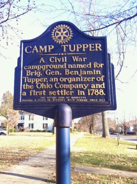
During the Civil War this mound was used as a campground, named after the Revolutionary War Brig. General Benjamin Tupper and therefore has a second marker seen below. General Tupper is buried in the Mound Cemetery.
Bob found the map below that was prepared in 1838 marking the main earthworks in Marietta. The early European settlers gave them Latin names:
2. Another of the earthworks was named Sacra Via or the sacred way, a pathway down to the Muskingum River and a large open area that included the Capitolium and the Quadranaou as well as two smaller mounds at the eastern and northern corners.
3. The library was built on top of the Capitolium in 1918.
4. The Quadranaou is a truncated pyramidal mound with ramps leading to the top. During the American Civil War it was used as a campground. It is also the one called Turtle mound. Research on this mound in the 1990s showed that it was aligned to within two-tenths of one degree with the winter solstice sunset.
All these earthworks are thought to date between 200 BC and 900 AD and could perhaps be older.
For additional information on the mounds and the Hopewell culture see:
http://en.wikipedia.org/wiki/Marietta_Earthworks
http://en.wikipedia.org/wiki/Hopewell_tradition
http://en.wikipedia.org/wiki/Mound_Cemetery_%28Marietta,_Ohio%29
Special thanks to Lou for taking and sending additional pictures of the mounds. The Sacra Via is the only earthworks on the map that I have not seen in person. On the next trip to Marietta we hope to visit it.


No comments:
Post a Comment