Thursday, March 31, 2022

if this is Thursday it must be postcards, 549


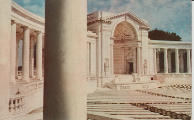
The Arlington Memorial Amphitheatre, Arlington Cemetery, VA

[photo by:  Richard G. Gilbert]


This unused MIRRO-KROME postcard distributed by H.S. Crocker Co., Inc. of San Francisco, California, was another card in the batch shared by friends K & J.  The code UN-44 is found at the upper left corner on the reverse.  MIRRO-KROME was the postcard trademark of H.S. Crocker Co., Inc. from 1950 to 2002.  It expired in 2003 when it was not renewed.  Just looking at the color on the postcard it is possible to guess that it was issued in the 1950s.  The photograph is credited to Richard G. Gilbert.


The picture is of the Arlington Memorial Amphitheater located in the Arlington National Cemetery, Arlington County, Virginia.  It is an outdoor amphitheater, exhibit hall and chapel.  Designed in 1913 and built between 1915 and 1920 as a larger replacement the older, wooden amphitheater built in 1873 near Arlington House that was renamed Tanner Amphitheater.  The photo shows only a portion of the newer elliptical structure.  In the center of the eastern steps is the Tomb of the Unknowns.  Veteran’s Day and Memorial Day services as well as memorial services and funerals are held at this site. 


The Amphitheater has been expanded and renovated several times in the intervening years.  In 1998 the remains of a Vietnam War unknown were exhumed and DNA tested.  United States Air Force 1st Lieutenant Michael Blassie was identified.  That resulted in a marble slab with “Honoring and Keeping Faith with America’s Missing Servicemen” being placed over the then empty grave.  The most recent renovation was in 2012. 


Thanks as always to K & J for sharing the postcards.


For additional information, see:


https://en.wikipedia.org/wiki/Arlington_Memorial_Amphitheater

https://trademarks.justia.com/716/10/mirro-krome-71610006.html


Thursday, March 24, 2022

If this is Thursday it must be postcards, 548


Vue sur le port et Monaco


Here is another black & white unused postcard shared by friends K & J.  At the lower left on the reverse is 406 Monaco, Vue sur le porte Monte Carlo.  It is a “Real-Photo” card distributed by C.A.P. Paris, France.  Other cards that included this one dated from the 1930s to the 1950s; therefore, it is likely this one comes from about the same time period.  Small and large luxury yachts can be seen anchored in the harbor.


Monaco is a sovereign city-state on the French Riviera a few miles west of the Liguria region of Italy.  The official language is French.  At 0.81 square miles (2.1 km) it is the second smallest sovereign state after Vatican City.  The government is a constitutional monarchy with Prince Albert II as head of state.  It is not formally part of the European Union (EU) but uses the euro as the currency and has the same border and customs policies.  


For its size, It is the most densely populated sovereign state, with about 19,000 inhabitants and has the world’s shortest coastline at about 2.38 miles or 3.83 km.  Tourist attractions that include the mild climate, the beautiful scenic views, railway connections, and the gambling facilities of Monte Carlo make it a popular destination for the rich.  With no personal income tax and low business taxes, Monaco is famous as a tax haven.  It is also a major banking center. 


Thanks to K & J for sharing the card.


For additional information, see:


https://en.wikipedia.org/wiki/Monaco


Thursday, March 17, 2022

If this is Thursday it must be postcards, 547


Salle Garnier, Monte Carlo, Monaco, ca 1920-1930s


The number 772 and MONTE CARLO – Le Théȃtre et les Terrasses appears at the lower left corner on the reverse.  On the back center line:   L. Gilletta et Cie, photo-édit, Nice [France].  It is difficult to date the card but given the clothing the people are wearing it appears that it would be in the 1920s or early 1930s.  The unused black & white photo postcard is one of several shared by friends K & J. 


The photograph shows part of the seaside front of the Salle Garnier, named after the architect, Charles Garnier. It is an opera house with the main public entrance located in the Monte Carlo Casino.  It seats 524 and opened in 1879.  Salle Garnier continues to be a venue for conferences and performance arts and where the Monte Carlo Ballet and Philharmonic Orchestra regularly perform.  It was not originally designed for opera but was used for that purpose and the stage area was remodeled in 1899 to make it more suitable for the opera. 


Monte Carlo Casino, Monaco


This second black & white unused postcard has the number 876 – MONTE CARLO – Le Casino d’Été at the lower left corner on the reverse.  The Monte Carlo Casino is a gambling and entertainment complex that includes the opera house.  The Casino opened in 1865.  The House of Grimaldi was facing possible bankruptcy due to breakaway towns that no longer paid taxes on olive oil and fruit.  The idea of opening a gambling casino was proposed by Princess Caroline, wife of Prince Florestan, as a way to replace the lost taxes with revenue from gambling.  The ruling royal family still has a majority interest in the Casino.  The citizens of Monaco are not allowed to enter the gaming rooms of the casino.  The Casino has undergone expansions and renovations.  Today Casino de Monte Carlo and tourism have been the primary source of income for the House of Grimaldi and the Monegasque economy. 


As always, thanks go to K & J for sharing the cards.


For additional information, see:


https://en.wikipedia.org/wiki/Op%C3%A9ra_de_Monte-Carlo

https://fr-m-wikipedia-org.translate.goog/wiki/Casino_de_Monte-Carlo?_x_tr_sl=fr&_x_tr_tl=en&_x_tr_hl=en-US&_x_tr_pto=op,sc

https://en.wikipedia.org/wiki/Monte_Carlo

https://en.wikipedia.org/wiki/Mounte_Carlo_Casino


Thursday, March 10, 2022

If this is Thursday it must be postcards, 546


1615 – La Turbie – vue general et le Mont Agel (alt 1110m)


This black & white unused postcard has a photograph identified as “1615 La Turbie, Vue general et le Mont Agel (alt 1110).  The card was produced by La Cigogne, 15 Rue St.-Francçis-de-Paule, Nice.  It was among several shared by K & J.  La Turbie is located in the Alpes-Martimes department of southeastern France.  It is difficult to tell the date when this photo may have been taken but since it is in black & white, it suggests it was before color pictures were mostly used for postcards or ca 1940s or even earlier. 


During Roman times Augustus celebrated his victory over the Ligurian tribes by erecting the large monument seen at the upper right in the picture at La Turbie (the trophy).  Visible in the left side background of the photo is Mont Agel on the border between France and Monaco. The title on the card says that the altitude is 1,110 m or 3,641 ft.  Other articles give the height at the top as 1,148 m (3,766 ft).  Today the Nice Air Base is located at the top.  Mont Agel is also the site of the Monte Carlo Golf Club.  The summer home of Prince Rainier III is high on the slopes of the mountain.


Automobile and bicycle races have been held in this mountainous area.  The auto race from Marseilles to Nice in 1897 included a hill climb of 17 km or 10 miles from Nice to La Turbie.  That race was won by André Michelin in a steam powered De Dion with the average speed of 31.8 km or 19.9 mph.  That seems extremely slow to us today!  After two deaths, one in 1900 and the one in 1903, the French Minister of the Interior issued an order to “stop the further use of the Nice-La Turbie course for automobiles.”  From 1968 to 1995 almost the same route as the cars had raced more than 60 years earlier was used as the last stage of the Paris-Nice cyclist race.  This is the same road where Princess Grace de Monaco was killed in a fatal accident in 1982. 


Once again, thank you to K & J for sharing the card.


For additional information, see:


https://en.wikipedia.org/wiki/La_Turbie

https://en.wikipedia.org/wiki/Mont_Agel

Thursday, March 3, 2022

If this is Thursday it must be postcards, 545


Eze, Provence-Alpes-Côte d’Azur, France


The photograph on this unused black & white postcard shows the perched village of Eze in Southern France.  The card has the number 1348 “Eze – Le Vieux village, la viaduct, la Moyenn, Corniche et le Cap Ferrat” at the upper right corner on the reverse.  The card is a product of Edition “La Cigogne” 15, Rue St.-Francois-de-Paule, Nice.  Without automobiles or people, it is difficult to estimate the year this picture was taken.  It came with several other similar cards from friends K & J.  Some of those cards appear to be from the 1930s, hence it possible this is approximately from the same time.


Eze is located about 5 miles or 8 km northeast of Nice on the French Riviera.  It has been described as an eagle’s nest since it is on a 1401 ft or 427 m high cliff above the sea.  The first settlements in the area were established in about 2000 BC.  In the late 1800s a cache or hoard of ancient Greek silver decorative shallow bowls called phialae dating from the 3rd century BC was found in Eze.  The bowls are now part of the British Museum’s collection.  This area was later occupied by Romans and later the Moors.  William of Provence drove the Moors out in 973.  From about 1388 to 1860 the history of Eze was often turbulent.  The town was fortified as a stronghold and switched hands between France and Turkey.  In 1860 the people of Eze unanimously decided to be designated part of France.


There are three roads called the Corniche Roads or cliff roads along the French Riviera that follow the mountainous stretch between Nice to Menton, Italy.  The top card shows the viaduct and part of the Moyenne Corniche.  The unused card below, with the number 1330 on the reverse, has a picture of another of the roads.  This road is called La Grande Corniche and shows a part of the snow covered Alps in the background.


La Grande Corniche au Col d'Eze


In 2012 I traveled to France with my daughter, my grandson, and his high school AP French class, a group consisting of about 40 teenagers, and 6 adults.  We had a wonderful tour guide and visited many amazing places.  Eze was the second perched village the group was scheduled to visit.  No cars or buses are allowed beyond a point and most of the way is a steep climb with lots of stairs up to the top where there are spectacular views of the sea.  Our guide told me she wanted me to stay at the bottom in a café while she took the students and the other adults up to the viewpoint.  I admit I was the oldest person in the group and it is unlikely that the guide had had someone my age on a tour before since she specialized in school tours.  Perhaps she thought the climb would be too much for me.  I said I would rather stay in Nice, spend a relaxing day enjoying the sea, walking down to the flower market, and shopping.  I definitely did not want to be parked in a café all day.  My daughter and grandson went to Eze with the group and told me about it later.  I was sorry to have missed it but I had a lovely day by myself and picked up this watercolor painting of Eze by a local artist at the flower market.


Eze Village


 Thanks to K & J for sharing the postcards. 


For additional information, see:


https://en.wikipedia.org/wiki/%C3%88ze

https://frenchmoments.eu/corniche-roads-of-the-french-riviera/


Tuesday, March 1, 2022

Cross-Country Skiing at Hyak, 2022


This week we set out to do some cross-country skiing at one of our favorite destinations for that purpose.  We have walked along the Palouse to Cascade trail in the spring, summer and fall and often skied here in the winter.  It is the old Chicago-Millwaukee-St.Paul-Pacific Railroad or Millwaukee Road route along Lake Keechelus just over Snoqualmie Pass summit at Hyak.  Because it is on an old rail line it is flat.  A plus is a heated restroom with running water and flush toilets.  There is also a sledding hill off to one side.  

 It is groomed with tracks for classic skiing and a nice wide middle area for the skating version of XC.  We tend to choose weekdays when there are fewer people.  Monday was a holiday and also the beginning of winter break for many of the local public schools so we were prepared for more people and children than we normally experience there.  As it turned out most of the people were families with young children using the sledding hill.  There were perhaps a few more skiers than we usually see but it was still not crowded and very pleasant.  There is also space along the left side for snow shoeing and a separate snow shoe trail than divides from the ski trail and goes into the woods parallel to the ski trail. 


After a couple of weeks of no new snow, the night before had brought about 10 inches of new fluffy snow making it a pleasant change from the week before when the tracks were basically ice and hard pack old snow.  Bob skied over to one of the park out buildings that had about 5 feet of snow around it.  


The weather was warm and sunny turning to graupel (snow pellets) as we headed back to the parking area.  We wore sweaters instead of five layers and jackets and were comfortable.  


We went back for another day of XC skiing on the following Saturday.  Many more people, again some new snow, and wonderful grooming.  It was a cold 26 degrees F with a wind and lots of gray clouds.  Jackets, hats and gloves were needed and appreciated.  Since it was a Saturday there were many more people out on skis, snow shoes, and sleds.  Even so, it was a wonderful ski day.  We were able to go much farther and even shared cookies with a hungry skier who had forgotten to bring a snack.