Thursday, July 29, 2021

If this is Thursday it must be postcards, 514


Ørsta, More og Romsdal, Norway, 1999


Two used postcards with views of Ørsta, Norway are shared this week.  We were privileged in 2014 to stay with a cousin who lives in this charming community.  Ørsta is found in the Sunnmøre region of Western Norway in the county of More og Romsdal.  Distributed by Olav Lystad of Ørsta, the card has the number 667.LIX at the lower left corner on the reverse. 


My father’s mother, Lil Anna, came from a large family and only a few migrated to America, hence there are many cousins of varying degrees, 2nd, 3rd, etc. who still live in Norway and can be found mostly on the western or southern coast.  Eldbjørg and her husband, Hans, were members of a folk dancing group that was on a tour in the United States.  Before they left Norway they contacted me and provided information about where they would be performing with the hope that we could meet in person.  Happily, we were able to watch them dance and also to invite them to our home for a visit the following day before they moved to their next stop.  Luckily, another performance venue was near where my brother lives and he and his family also got to meet and visit with them.  Because my grandmother did not have brothers and sisters living in America my brother and I grew up with only 2 cousins.  Now we have found dozens!


The museum sign on the side of the building has a map of the farm


Two of the buildings on the museum grounds with sod roofs and grass and even small shrubs growing on top.  The old farmsteads raised the buildings off the ground to prevent rodents from getting into stored items.


One of the work rooms in the museum used to teach spinning and weaving


Two of Elbjørg's looms.  She has several looms, at least two at her home and others in storage.  These are set up and students are working on projects.


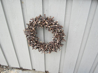
Wreath made from twigs displayed on the side of the museum


Ørsta has a population of about 11,000.  It is a beautiful, picturesque fjord hamlet that was part of Volda until it was separated in 1883.  The Brudavoll Farm, part of the Sunnmøre Museum Foundation, is about 3 miles or 5 km from Ørsta.  Eldbjørg is a retired teacher of folk art, mostly weaving, and collects looms.  She volunteers teaching traditional Norwegian weaving at the museum.  The museum grounds also contain several old farm buildings with the traditional sod and grass on the roof. 


The main industries include mechanical and furniture manufacturing, fishing, agriculture, and aquaculture.  There is a regional airport that serves several neighboring communities.  Driving through the Eiksund Tunnel, the deepest undersea tunnel at 942 ft or 287 m below the sea surface, was an experience. 


“Light impression of Norway,” undated, ca 1997


This second postcard has an aerial view of Ørsta with photo by Per Eide, printed by Hatlehols.  This card has the number 0106 – Ørsta, Norway at the upper left corner on the reverse.


For more information, see:


https://en.wikipedia.org/wiki/Ørsta


Thursday, July 22, 2021

If this is Thursday it must be postcards, 513


Hawai’i Volcanoes National Park, 2008

[photo:  www.VolcanoMan.com]


Both of the postcards shared this week are used.  They were purchased at the Hawai’i Volcanoes National Park and are Impact, Designed and Distributed in the U.S.A. cards.  The number 45069 appears at the lower left on the reverse of the card above.  The photographer is identified as VolcanoMan.com. 


The trail leading out to the caldera view.  Wisps of sulfur smelling steam coming out of the ground


View of the caldera


On a ledge in the caldera we saw these flowers that had been left as an offering to the volcano


When we visited in 2008 the volcanic activity was quiet with just a little steam coming from vents in ground and in the crater.  More recently there has been substantial volcanic activity and lava flow.  The Park is located on the island of Hawaii and has two volcanoes, Kilauea and Mauna Loa.  It was closed to the public 2018 due to volcanic activity such as, toxic ash clouds, earthquakes, explosions, and road damage.  The visitor center and some other portions of the park were reopened to the public in 2020.  However, some of the trails, road segments, and the Jagger Museum of the Hawaiian Volcano Observatory remain closed indefinitely to the public.  


 In 2008 it was possible to walk on a trail up to close viewing areas of the Halema’uma’u caldera.  We also drove to Chain of the Craters Road where the lava had covered the road before falling into the sea.  At that time, it was possible to walk on the cooled and dry, bumpy surface almost to the cliff edge.  It was amazing to see green plants beginning to grow in the lava cracks.  It was also extremely hot with the sun reflecting off the black shiny surface of the lava.  There was a portable Ranger Station with Rangers available to help tourists who might be experiencing heat exhaustion.  


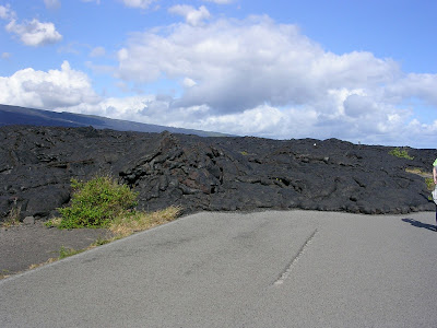
Two year old lava covering the road


This was kind of funny, a road closed sign nearly buried in the lava


When it was a liquid the lava ran over the cliff and into the sea when it was flowing.  This lava is two years old and solid rock.  It was very difficult, bumpy, and sharp to walk upon.


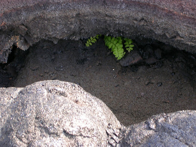
The resilience of life, new vegetation beginning to grow in the lava covered road


Established 1916 in the 1980s this Park was recognized as an International Biosphere Reserve and a World Heritage Site. The main purposes of the park are to protect, study, and perpetuate the Hawaiian ecosystems and Hawaiian culture connected to the area as well as to provide access to Kilaueau and Mauna Loa.  Because these two volcanoes are so active, it gives scientists insight into how the Hawaiian Islands developed and also general studies of volcanism.  An image of the park appears on a quarter in the America the Beautiful Quarter series released in 2012.  


Hawai’i Volcanoes National Park, 2008

[photo:  G. Brad Lewis]


This second postcard, above, has the number 61538 at the lower left corner on the reverse.  It is also an Impact, Designed and Distributed in the U.S.A. card. 


For additional information, see:


https://en.wikipedia.org/wiki/Hawai’i_Volcanoes_National_Park


Thursday, July 15, 2021

If this is Thursday it must be postcards, 512


Sørfjorden, Hardanger, Norway, ca 1921


Sent to Petra Landaas Lee in November 1921 this used postcard contains a greetings for Christmas and the New Year to Petra her husband and little Marjorie.  The card was sent from Nesttun a community within the greater Bergen area.  Jenny says her mother was at that time 79 years old and still cooking and baking all the things for the holidays.  Jenny also mentions that it has been a very long time she has heard from Petra.  The card does not have any information about the photographer or the distribution and printing of the card. 


Looking down the fjord from the hotel

 
Another fjord view
 

The Ullenvang hotel is situated right on the fjord


The 24 mile or 38 km long Sørfjorden is an inner arm of the main Hardangerfjod and is located in Ullensvang, Vestland.  It is the longest arm that branches off and stretches from just north of Kinsavik to Odda in the south.  Several villages that line the sides of the fjord have fruit farms and orchards growing apples and cherries.  The hillsides are steep to very steep.  When we visited in 2014, we noticed that some of the apple orchards had ladders up the hillsides so the trees could be tended and the fruit picked at harvest time. 


 This orchard continued up the hillside.  It was not quite as steep as others we saw.


Nesttun is an urban area 10 km or slightly more than 6 miles south of Bergen city center.  It was the center of Fana before the merge with Bergen in 1972.  Today there is a pedestrian only shopping mall, small shops, a library and a church.  Flooding from the river that flows through Nesttun is a recurring problem.  The Bergen Light Rail system will connect and allow access to the shopping mall.


For additional information, see:


https://en.wikipedia.org/Nesttun

https://wikipedia.org/Sørfjorden_(Hardanger)


Thursday, July 8, 2021

If this is Thursday it must be postcards, 511


Pu’uhonua o Hōnaunau National Historical Park, Hawaii, 2008


Bob Fewell is credited with the photograph on this used postcard.  The number 15140 appears at the lower left on the reverse.  The blurb at the upper left on the reverse:  “Pu’uhonua Hōnaunau National Park, Hale o Keawe.  The bones of 23 chiefs were once held in this temple and were believed to give spiritual power to the surrounding refuge area.”  The card was designed and distributed by Hawai’I Natural History Association, Hawai’I National Park.


This National Historical Park is located on the west coast of the island of Hawaii.  The park covers 420 acres and was originally established in 1955 as City of Refuge National Historical Park.  In 2000 the name was changed to the current name and spelling.  Archeological sites including temple platforms, royal fish ponds, and some village sites and several reconstructed structures such as the Hale o Keawe temple pictured on the card are found in the park.  Until the early 1800s this was a place of refuge for people who had broken ancient laws, warriors who had been defeated in battle, and non-combatants who wished to avoid certain death.  The offender would be absolved by a priest and free to leave.  It was also the home to several generations of powerful chiefs. 


Tikis, 2008

Tikis represent strong concepts like knowledge, power, wisdom and prosperitiy.  Each Tiki has its own meaning.


View of the temple enclosure from the opposite side, 2008


Workshop where the Tikis and wooden boats are made, 2008
 

For additional information, see:


https://en.wikipedia.org/wiki/Pu%CA%BBuhonua_o_H%C5%8Dnaunau_National_Historical_Park


Monday, July 5, 2021

Palouse to Cascade Trail, 2021


 Lots of daisies and foxglove on the way up to the main trail


Most of the trail looks like this


Now named the Palouse to Cascade Trail; it was formerly the John Wayne Pioneer Trail or Iron Horse State Park Trail.  At 44 miles and less than a one hour drive from home it is one of the closest hikes for us.  We got up at a normal time and still had an early start before the day got too hot.  We have had a lot of really hot days recently.  Since neither of us do as well in the heat as we did when we were younger, Bob watches the weather forecasts and chooses the most comfortable days for our hikes.   


The trailhead parking lot is large and has an outhouse.  This hike requires a Discover Pass.  From the parking area there is a narrow steep trail up to what was originally part of the Chicago Milwaukee St. Paul and Pacific Railroad.  Because it is an old railroad bed it is wide and nicely graded with a gentle incline.  The trail is open to hikers, bikers, horses and rock climbers.


Rock climbing lessons for kids summer camp


Approaching the first trestle crossing with rock climbing class on the right


On the day we went there were 4 climbing groups that included kids of all ages from very young to older teens in a summer camp and one group of beginning adult climbers.  That made for a total of approximately 40 to 50 rock climbers.  There are 2 port-a-potties at the climbing sites.  There were more bikers than hikers and no horses the day we were there. 


One of the trestles


 Most of the way it is not possible to see the highway below; however, we did have one view


As mentioned previously, I do not like heights and suffer from some vertigo at times.  This trail has trestles that proved a challenge for me.  They are extremely high off the ground, but strong, paved and built to hold up a train! However, I still had difficulty getting across them.  Bob held my hand and I focused on the center of the path, not looking ahead nor to either side, and hurried as fast as possible to get across.  We crossed two of the trestles and used the third, much longer one, as the turn-around point.  Bob went across that one and took photos along the way while I waited for him to return.  


 A wonderful surprise was the number of flowers on display along the trail. 


 Clover


 Daisies


 Penstemon


Delicate small twin flower


Harebells also called Scotch bells


Fireweed


Foxglove


Tiger Lilies


This was a 5.6-mile RT hike for us with an elevation gain of 300 ft.

Count for the day:  17 hikers, 28 bikers, 40 to 50 rock climbers, and one dog.