Thursday, November 30, 2017

If this is Thursday it must be postcards, 327


 Stonegate, City of York, Yorkshire, England, ca 1950s-1960s

Stonegate, one of the oldest streets in the City of York, Yorkshire, England, is shown on the unused postcard (1950s or 1960s ) above as it looks at night.  The card is a Colourmaster International published by Photo Precision Limited, St. Ives, Huntingdon.  It has two numbers on the reverse, YOR 310 at the top and PLX22102 at the bottom of the center divide. 
First mentioned as early as 1118 AD, Stonegate was built on the Via Praetoria, a Roman road, and accessed through a gateway called Porta Praetoria, now under St. Helens Square.  It is thought that the name was derived from the stone brought by boat from quarries near Tadcaster to a landing place near where the Guildhall stands today.  That stone was used to construct the Minster.  It is also possible that the name comes from the original stone road built by the Romans. 

The street was once called the “Street of the Printers,’” because during the 16th century and was well known for books shops and printers.  Although several signs can be seen on the postcard picture one of the more famous ones is missing.  It is of a chained, red devil, and sits at the top of the door to number 33.  The devil is a reference to the boys who were apprenticed or assistants to the printer and had the job of carrying hot metal type.  According to folklore, every print shop was haunted by a mischief-maker, one blamed for misspelled words, removal of lines, or inverted type.  The printer’s assistant thus acquired the nickname “the printer’s devil.”

Today Stonegate is home to interesting little shops selling things from jewelry to teddy bears.  Books stores can still be found there as well.  From the picture on the card it looks like a person would step back in time or into a Harry Potter scene walking along the street.

This card, like several others shared, comes from the travel collection received from J & K.  Thank you, they are much appreciated.

For additional information, see:

http://www.york-united-kingdom.co.uk/stonegate/
http://secretyork.com/the-stonegate-devil/

Saturday, November 25, 2017

A family gathering . . .


Right after Thanksgiving, appropriately enough, and just before Christmas, finally something to show after many years of promising that these were in the works, here are the first 3 volumes of a projected multi volume set on the extended family history.  The books are being sold on an invitation only basis.

Interested family members can contact me by email or by leaving a comment on this post with your return email address and I will send the link(s) to the online publisher so purchases can be made directly from Blurb.com.  I will delete the email addresses from the blog after I reply.

Blurb is an online self-publisher and offers several formats for each of the books ranging from soft cover (paperback) to hardbound versions and a digital format ebook.  The pictures above show the hardbound image wrap option.  Currently only the Lorig book is available in all the options.  The ebook version can be read using a tablet such as an iPad or Kindle or smart phone.  The other two books were published using an older format and I am still working on converting them so they can be viewed as ebooks.  Hopefully the conversion will be successful and they will also become available as ebooks.  I'll post an update when that happens. 
In the meantime they are available in soft cover and hardbound.
 
In progress volumes will cover the Landaas, Lee, and Thompson families and perhaps a couple more given enough time and energy and if my “little gray cells” keep chugging along at full capacity.

I am so thankful to get these done and hope that the effort will preserve some of our family history for the generations to come. 

Thursday, November 23, 2017

If this is Thursday it must be postcards, 326


Prebends Bridge and Castle Durham

Here is another postcard from the travel collection that shows the Prebends Bridge and Durham Castle in the U.K.  The card is unused, a product of Photo Precision Limited, St. Ives, Huntingdon, Cambs., Great Britain.  Two identifying numbers are found on the reverse, DU 399 and PLX20603.

A footbridge over the River Wear was built at this location in 1574 but was swept away during a flood in 1771.  George Nicholson then designed this bridge, called the Prebends Bridge, and it was constructed during the years between 1772 and 1778.  A restoration of this bridge was done in 1956-1957.  The bridge forms part of the estate of Durham Cathedral.  It us used primarily as a footbridge since it joins riverside paths and leads to a closed road barrier, but it is wide enough for vehicles and was temporarily opened to them in 2010 when roadwork on the main roads necessitated it. 

Durham Castle, an example of early motte and bailey castles, seen above on the hillside is a Norman castle built in the 11th century.   It was the seat of the Bishop of Durham who was appointed by the King and exercised royal authority on his behalf.  It remained the bishop’s palace until the castle was donated to a newly formed college in 1837.  Since 1840 the castle has been occupied by University College, Durham.  Although it is a working building with over 100 students the castle does offer guided tours for visitors. 

Trivia:  The Great Hall is 46 ft or 14 meters high and over 98 ft 30 meters long.  The castle has two chapels, the Norman Chapel built about 1078 and the Tunstall’s Chapel, built in 1540.  In addition to services the chapels are also used for theatrical performances and other like purposes.  During university vacation periods the college offers rooms mostly for academic conferences.  The entrance was remodeled in the 18th and 19th centuries.  The castle is a UNESCO World Heritage Site.  


Thanks to J & K for sharing the postcard.

For additional information, see:

https://en.wikipedia.org/wiki/Prebends_Bridge
https://en.wikipedia.org/wiki/Durham_Castle

Thursday, November 16, 2017

If this is Thursday it must be postcards, 325


Roman Baths and Hot Springs, Bath, Somerset, England

Today’s unused postcard published for the City of Bath by the Bath City Council has photographs of the Roman Baths in Bath, Somerset, England.  The top left picture shows a northeast view of the pillar base of a portico leading to the sacred spring named for the Celtic goddess, Sulis, and associated later with the Roman goddess Minerva.  The lower left photo is a northwest view of the ruins of a structure adjacent to the sacred spring building.  The larger photograph on the right has two re-positioned corner stones of a sacrificial altar.  In background is the Pump room foundation, 1790.  The card has the number 1246 in the square where a stamp would be placed.  The baths are a major tourist attraction with more than one million visitors a year.

The Roman Baths are below the modern street level.  Entrance is through an 1897 concert hall.  Visitors can see the Baths and the associated museum but are no longer allowed to enter the water due to health concerns related to lead pipes and infectious diseases such as meningitis.  A newer Thermae Bath Spa, designed by Nicholas Grimshaw and Partners and the refurbished Cross Bath allow bathers to experience the waters instead.


The postcard below has a photograph of the Kings Bath viewed through the Roman arch.  This was probably built in the late 10th century for Edgar the first King of all England by the Benedictine Bishop of Bath.  It has been possessed and controlled by the City of Bath since 1554. The card was photographed and published by Unichrome and bears the identification number of 1169.


Where does the water come from and how hot does it get?  The water bubbles up from the ground at Bath falls as rain on Mendip Hills.  It percolates down through limestone aquifiers thousands of feet where it is heated by geothermal energy to temperatures between 156 and 204 degrees F or 69 and 96 degrees C.  The water then rises to the surface along fissures and faults in the limestone.  There were three baths, the caldarium, hot bath; the tepidarium, lukewarm bath; and the frigidarium, cold bath.  Drinking the water is also considered a curative or health practice.  A new spa water borehole was sunk to provide a supply of clean, safe water for drinking in the Pump Room.  The neo-classical Grand Pump Room salon is still used for both taking the waters and for social functions.

The first shrine at the hot springs was built by the Celts.  The Romans constructed a temple (60-70 AD) and the bathing complex was gradually building over a period of about 300 years.  The baths have been modified several different times due to disrepair after the Roman withdrawal, flooding and silting.  In 1810 it was thought that the Hot Springs were failing or had failed but upon investigation it was discovered that the water had changed course.  Once the water was re-directed to its original course the baths filled in less time.

The museum houses artifacts from the Roman period including the remains of an elaborate hypocaust heating system that served the sweat rooms.   It is a little hard to imagine how large these bathing rooms were.  I have not been to these in Bath, but the Cluny Museum in Paris is built over old Roman Baths.  One is marked as a Roman bath outside the building but not labeled hot, cold or medium. The frigidarium or cold water bath, the warm and hot water rooms are identified and located on the lower level of what is currently the museum.  Perhaps the picture below from the Cluny will provide some perspective on size.  Originally there must have been walls like a modern swimming pool around the room edges but those no longer exist.  As far as we could tell the windows do not date from the Roman times but were added later.


 Roman Bath, Cluny Museum, Paris, France

These postcards were among those in a group of travel cards shared by J & K and much appreciated.  Thanks!

For more information and additional photographs, see:

https://en.wikipedia.org/wiki/Roman_Baths_(Bath)

Thursday, November 9, 2017

If this is Thursday it must be postcards, 324


Manitou Cliff Dwellings, Colorado, 1952

The used postcard this week is another Linen-Type but without the typical white border.  It is dated 1952.  A Sanborn Souvenir Co. of Denver, Colorado publication, this card like the one last week uses C.T. Art-Colortone.  It has an identifying number on the reverse at the upper left, 2176. 

The Anasazi lived and migrated between 1200 BC and 1300 AD, within the Four Corners area of the Southwestern United States, several hundred miles southwest of Manitou Springs.  The dwellings pictured on the card were rebuilt in the early 1900s to serve as a museum, tourist attraction, and to preserve the culture of the people who once lived in them.  Reconstruction began in 1904 and the museum opened to the public in 1907.  The stones for the dwellings were taken from collapsed Anasazi buildings near Cortez, Colorado, shipped by train to Manitou Springs where they were reassembled at their current location.  In addition to this group of cliff dwellings the museum also has displays of what life was like for the people who lived here, exhibits that include archaeological artifacts, tools, pottery, and weapons.  Visitors can walk through the dwellings.  Anthropologist, Dr. Edgar Lee Hewett, and Virginia McClurg, founder of the Colorado Cliff Dwelling Association, approved and participated in the project. 

For additional information, see:


https://en.wikipedia.org/wiki/Manitou_Cliff-Dwellings
 

Thursday, November 2, 2017

If this is Thursday it must be postcards, 323


Highway Through the Needles, Custer State Park, Black Hills, South Dakota

This linen-type postcard, #7A-H2560, was published for the Burgess Co., Inc. of Keystone, South Dakota using the genuine Curteich-Chicago C.T. Art-Colortone method.  The title is given as, 116 Highway Through the Needles, Custer State Park, Black Hills, So. Dakota.  As mentioned previously, linen-type cards were popular during the 1930s and 1940s but some were also produced into the 1950s.  The Needles really do look this surreal.  An interesting place to visit.


Perhaps this beautiful but ominous sky should have warned us that . . .


the thunder, lightning and hail were almost upon us

On our long road trip this past July Bob and I stopped at parks and other places of interest both coming and going.  One of the places we visited was Custer State Park in South Dakota.  There are separate roads within the park so one can choose different things to see.  We were able to do both the Wildlife Loop Road and the Highway Through the Needles.  And while the day started out nice enough we did experience twenty-minutes or so of thunder, lightning with hail that left about 3 inches of hail on the road and hillsides before once again clearing.  


 As we rounded the bend we could see this large herd of bison


 There were lots of calves and all seemed calm, grazing . . .


but just before the storm began the herd started moving closer to the road.  This one is just a little too close, even looking through the closed car window.

The park is home to about 1500 bison aka buffalo.  We came upon a herd of about 200 or 300, some were very near to the road and others were dispersed on the surrounding hills.  A few minutes before the storm hit we noticed they were getting a little agitated and starting to move toward the trees and the roadway.  Several cars, including ours, were parked along side watching the animals.  Some people had gotten out to take photos.  We decided we should move the car, as we knew once the herd started to cross the roadway we would have a long wait for all the animals to pass and we did not want to get too close.   We had just pulled out and started then looked back to see the first bison beginning to cross the street.  It was only a few moments later that the thunder and lightning started.  The animals must have sensed the impending storm and started moving toward shelter.  


Besides the buffalo some of the animals we saw --


Pronghorn antelope 


 Mule deer


Mountain goat and her two kids


The park named after Lt. Colonel George Armstrong Custer and established in 1912, is huge, covering some 71,000 acres and is home to a number of wild animals.  The scenery is beautiful and the two routes we took were well worth the time.  In addition to the wildlife area is The Needles shown on the card above.  It is a region of granite pillars, towers and spires.  Originally the Needles were suggested as the place for the carvings that eventually ended up on nearby Mt. Rushmore instead.  The Needles attracts about 300,000 visitors a year both tourists and rock climbers.  


Highway through the Needles parking area near the main attraction


The Eye of the Needle


 The scenery and animals kept our attention and kept us in the car most of the time so not many flower photos this time


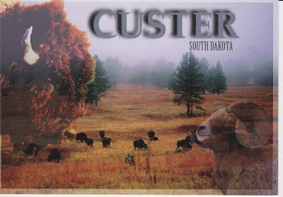
The new postcard below was found at the Mt. Rushmore gift shop, RP 498,  and shows an example of the open wildlife region


For more information, see: 
https://en.wikipedia.org/wiki/Needles_(Black_Hills)
https://en.wikipedia.org/wiki/Custer_Stake_Park


For more information, see: 
https://en.wikipedia.org/wiki/Needles_(Black_Hills)
https://en.wikipedia.org/wiki/Custer_Stake_Park