Showing posts with label Alaska. Show all posts

Thursday, September 17, 2020

If this is Thursday it must be postcards, 469


Three Brothers, chiefs of the Kagwantan, Tlingit, Southeastern Alaska, 1906

[photo:  Case and Draper]

 The Case and Draper photographic studio of Southeastern Alaska is credited with the 1906 picture of three brothers on this unused Garfinkel Publication postcard.  At the bottom center of the reverse is:  FPC28.  The card was printed in Canada.

The three brothers in the photo are not named but were chiefs of the Kagwantan, or burnt house people, one of the Tlingit clans, and are each holding a raven rattle.  Two are wearing “Chilkat blankets, highly esteemed robes of nobility,” according the blurb on the reverse of the card.  Chilkat weaving uses one of the most complex weaving techniques and a blanket like one of these could take a year to make.  Today sheep wool might be used but when these blankets were woven the primary materials would have been mountain goat wool, dog fur, and yellow cedar bark.  The designs are traditionally in ovoid, U-form, and S-form shapes, highly stylized and contain clan crests, figures from oral history, and often animals.  Dominant colors are yellow and black with blue as a secondary color.  The weavings are done on looms that have only a top frame and vertical supports.  Vertical sections are completed instead of moving horizontally from end to end.  This system tends to break the designs into vertical columns.  Northwest Coast art is mostly bilaterally symmetrical.  Fringes and buttons are sometimes added decorations.  In addition to blankets the weavings are used for robes, dance tunics, aprons, leggings shirts, vests, hats, and wall hangings.  The blankets worn in the picture would traditionally be used at potlatch ceremonies.

William Howard Case and H. Horace Draper formed a partnership in 1898 and had a photographic studio in Skagway, Alaska.  In the beginning they worked out of a tent that allowed them to travel and take photographs.  They became popular for “Documenting the unknown” and eventually had a store that sold curios, photographic equipment, and souvenirs and well as their own work.  

Case was born in Iowa in 1868 and lived in South Dakota and Oregon before going to Alaska during the Klondike Gold Rush of 1898.  His partnership with Draper was dissolved in 1907.  Case moved to Juneau where he opened his own studio.  He died in 1920 and was survived by his three children.  Case’s studio was taken over by E.C. Adams.  

Herbert Horace Draper was born 1855 in Rockford, Illinois.  His family moved from Michigan to Oregon when he was 19.  He also went to Alaska during the 1898 Gold Rush.  He married a local school teacher.   After the partnership with Case was dissolved, he continued to run the studio under the name Draper and Co. until his death in 1913.  Draper’s studio was acquired by Keller Brothers Drug Company.

Digital images of their work can be found at Orbis Cascade Alliance and the Alaska State Library.  

For additional information, see:

https://en.wikipedia.org/wiki/Case_&_Draper
https://en.wikipedia.org/wiki/Chilkat_weaving

Thursday, September 10, 2020

If this is Thursday it must be postcards, 468


Alaskan dog sled, ca 1930s

This unused Lantern Press edition postcard has a photograph of an Alaskan dog sled team.  The image is numbered 31635 and looks to date from the 1930s.  The card was purchased at a gift shop in Ketchikan, Alaska in 2019.

Dog sleds with one or more dog pulling a sled or sleigh can be used to travel over ice and through snow and also to pull logs and other cargo.  Sleds pulled by dogs have been used for thousands of years.  French Canadian trappers used dog sleds for their own transportation as well as hauling the fur hides.  Rural people used dog sleds to haul logs for wood and fuel.  They have been used in Alaska, Greenland, and Siberia as well as other cold snowy places.  One dog or several, called a team, is used for pulling the sleds.  Dogs can pull side by side in pairs as shown in the picture, or as in Greenland, they can pull in a fan shape in front of the sled. 


The dog team pulling the sled in the photo has nine members.  Each dog or pair of dogs has a specific job.  The musher gives the command and the lead dog’s duty is to give the signals to the other dogs. There can be a pair of lead dogs or just one as shown in this example. If point dogs are used, they are located just behind the leader(s).  Swing dogs come next, then team dogs, and the strong wheel dogs are found closest to the sled.  Wheel dogs need to be especially powerful as they are used to pull the sled out from the snow if it slows or gets stuck.  In general, the dogs selected are chosen for their strength, health, endurance, and speed.  The dogs in the picture do not have “booties” on their feet for protection from the ice and snow; however, most long-distance sled dogs today wear protection on their feet.  Siberian Huskies, Alaskan Malamutes and Alaskan Huskies are the typical breeds used in dog sledding.  Faster, short-haired hounds are sometimes used for sprint races but are more difficult to train to pull a sled and do not have the endurance for the longer distances.  Puppies, at about 6 months of age, start training by pulling a small log behind them.

The annual Alaskan Iditarod Trail Sled Dog Race, established in 1973, is a long-distance race of 938 miles or 1,510 km.  The race is run in March and goes from Anchorage to Nome, Alaska.  This very popular sporting event brings the top mushers and their dog teams from all over the globe.  With more than 50 mushers and about 1,000 dogs from 14 countries competing, the dogs and the mushers become local celebrities. The course record of 8 days 3 hours 40 minutes and 13 seconds was set by Mitch Seavey in 2017. 

Why are the sled drivers called mushers?  It turns out the words “mush” and “musher” are English language corruptions of a sort from the French Canadian “marche” used by trappers to start the dogs pulling the sled. 

For additional information, see:

https://en.wikipedia.org/wiki/Dog_sled
https://en.wikipedia.org/wiki/Iditarod_Trail_Sled_Dog_Race
http://www.todayifoundout.com/index.php/2016/02/say-mush-make-sled-dogs-go/

Thursday, August 22, 2019

If this is Thursday it must be postcards, 413


Haida Village, Haida Gwaii, Alaska, 1890


Today’s featured postcard is another one I found in a shop in Ketchikan.  Richard Maynard is identified as the photographer on the card dated 1890*.  The picture shows a Haida Village, Haida Gwaii also called Queen Charlotte Islands, off the northern Pacific Coast of Canada.  The blurb on the reverse states:  “Each house in this village was identified with crests which were displayed on mortuary poles and house front.”  The card was printed in Canada and is a Native Elements product, NativeNorthwest.com, Vancouver, B.C., Canada.

There are between 40 and 60 islands in the archipelago that includes the two main islands, Graham Island (Kiis Gwaay) on the north and Moresby Island (Taawxii Xaaydaga Gwaay.yaay linagwaay**—south people island or Gwaay Haanas—islands of Beauty). There are also approximately 150 smaller islands. 

Archaeologists have established that the Haida people have lived on the islands for 13,000 years.  Today form about half of the population.  They have their own acting government called the Council of the Haida Nation.  The islands were formerly known as the Queen Charlotte Islands or “the Charlottes.”  In 2010 the Haida Gwaii Reconciliation Act, in an agreement between British Columbia and the Haida people, renamed them.

The Haida population was around 30,000 inhabitants until the Europeans arrived bringing with them diseases such as smallpox, measles, typhoid, and syphilis.  About 90% of the people died from these illnesses during the 1800s.  By 1900 there were only 350 people remaining and many of the towns and villages had been abandoned.  Today the population living on the islands is about 4,500.  Many of the native peoples moved to cannery towns on the mainland or to Vancouver Island.  The two remaining active island communities are Skidgate, shown on the postcard, and Old Massett, each having a population of about 700 individuals. 

It is not known for certain how the original Haida people came to settle the islands but anthropologists have found striking parallels between the inhabitants of the Kamchatka Peninsula and those of the native peoples of the Pacific Northwest Coast. 

The photographer, Richard Maynard (1832-1907) was Canadian and known mainly for his pictures featuring landscape views of British Columbia, coastal Alaska, and the Pribiloff Islands of the Bering Sea.  Maynard’s wife, Hannah, was also a photographer.  Many of his prints and personal papers were collected by Charles Newcombe.  The negatives of pictures taken by both Maynard and his wife were donated to sold by the son, Albert, to the British Columbia Archives.

For additional information about Haida Gwaii and other examples of Maynard’s photography, see:

https://en.wikipedia.org/wiki/Haida_Gwaii
https://en.wikipedia.org/wiki/Richard_Maynard_(photographer)


———————————————————————————————

*  There is another similar photograph on Wikipedia that is labeled “Houses and totem poles, Skidegate, 26 July 1878 (George Mercer Dawson, Geological Survey of Canada, NAC-PA-37756).”   I’m not sure if both are the same photograph or two different pictures of the same village taken at different times.

**The native names use diacritical marks and letters that I do not have on my computer so these may not be spelled exactly as they should be.

Thursday, August 15, 2019

If this is Thursday it must be postcards, 412


Misty Fjords, Ketchikan, Alaska


When I spotted this postcard in a shop in Ketchikan with a photograph of Misty Fjord National Monument in Alaska by Michael M. Anderson it immediately reminded me of places in Norway.  The card is another “Alaska Joe” original distributed by Greatland Classic Sales Col, Inc. and has the number 82-13BG on the reverse.  The blurb on the card states: “Misty Fjord National Monument is home to incredible beauty with its granite cliffs extending to the sky and its gorgeous blue lakes.”

Located in a portion of the Tongass National Forest in Alaska’s Panhandle, about 40 miles or 64 km east of Ketchikan, the first European to visit was George Vancouver in 1793.  It is a remote area accessed by cruise ships or aircraft.  There are overnight charter services for people wanting to spend more exploring by kayak. Our cruise ship did not visit Misty Fjords so we did not see this in person. 

John Muir compared its geology and glacial morphology to Yosemite Valley.  The light colored granite sculpted by glaciers is about 50 to 70 million years old.  Even though they are not manmade many of the glacial valleys are called canals filled with sea water.  The near-vertical walls rise 2,000 to 3,000 ft or 600 to 900 m above the sea level and drop into the sea another 1,000 ft or 300 m below.  There are several small glaciers in the high plateaus and valleys. 

President Jimmy Carter proclaimed it a national monument in 1978. 

For additional information, see:

https://en.wikipedia.org/wiki/Misty_Fjords_National_Monument

Thursday, August 8, 2019

If this is Thursday it must be postcards, 411


Creek Street, Ketchikan, Alaska


The Creek Street postcard shared this week has a photo by Hamilton Gelhar and is issued by fishcreekalaska.com.  There are no identifying numbers or an information blurb on the card.


And I thought we had a lot of stairs!  Ketchikan is built on very steep hills.  We saw lots of houses with steps like these.  These stairs connect the upper road with the Married Man's Trail.


 A little ways ahead the narrow walkway between the buildings along the creek was lined with small shops. 


The buildings are on pilings in the creek

On the walk back from the Totem Heritage Center we took the Married Man’s Trail that leads down into Creek Street.  Ketchikan’s main industry is fishing and the fish canneries.  It has been called the “Salmon Capital of the World.”  Another industry was the Ketchikan Pulp Company that operated for 40 years until it was shut down in 1997.  Tourism is a major industry today. 


 A woman dressed in costume was inviting guests into the Dolly's House museum


Creek Street housed the red light district with bars and bordellos.  Its most famous brothel, Dolly’s House, has been turned into a museum where for a $10 fee visitors can learn interesting things about the bawdy days.  Prostitution was illegal on land; however, the owners of these establishments built in the water to get around that law.  Dolly Arthur bought her house for $800 and was the madam until age 72.


 Along the Married Man's Trail


The Married Man’s Trail that winds down the hillside and connects to Creek Street was supposed to be a way a married man could sneak out the to bars and bordellos.  


 It even has a road sign


Looking down from the Married Man's Trail on the creek below


Larger view of the fish sculpture in the creek

Thursday, August 1, 2019

If this is Thursday it must be poscards, 410


 Ketchikan, Alaska

This postcard above has a photo of a street in Ketchikan, Alaska by Michael M. Anderson.  The card is an “Alaska Joe” original printed in Italy by Greatland Classic Sales Co., Inc.  The identifying number, 82-134B, is found on the back of the card.

Ketchikan was the last Alaska stop on the cruise.  The day was sunny and beautiful; an anomaly according to my Juneau friend who claimed that Ketchikan gets the most rain of all the southeastern towns.  According the blurb on the back of the postcard Ketchikan was Alaska’s first city and the downtown area is a National Historic District.  The town is named after the Ketchikan Creek that flows through it and empties into the Tongass Narrows.  The Creek was a summer fish camp for Tlingit natives well before the town was established in 1885.


Beaver Clan House at Saxman Totem Park, as seen from the ship

We had seen a few totem poles in Sitka and wanted to see more.  Ketchikan has four major areas with totem poles, Saxman Totem Park, about 2 miles to the south; Totem Bight State Park, 10 miles to the north; Potlach Park, adjacent to Totem Bight; and the Totem Heritage Center within walking distance of where the cruise ships dock.  There are shuttle buses available to take visitors to Saxman, Totem Bight, and Potlach Park.  Most of the totem poles at Saxman and Totem Bight are re-carvings of older poles.  We chose to walk to the Totem Heritage center, which has displays of preserved 19th century poles, that were rescued from abandoned villages near Ketchikan, as well as some newer poles.  It took us about 20 minutes to walk from the dock to the museum.  On the return trip we took a different route and stopped at several small shops so although it was a shorter distance it took a bit longer.


The Totem Heritage Center is located next to the city park and the fish hatchery.  We found displays of old totem poles, some newer carved poles, and examples of other native art.  It had the added advantage of young native docents who were happy to answer any questions and relate information about the displays and the native peoples who live and lived in that area.  


There were totem poles outside the museum and individual carved figures on the sides of the museum building.  Some of the poles were painted and some were not.  Inside the museum there was a room with very old poles under glass for preservation.  Each pole tells a story. 

   
This pole was near the museum entrance


 Recent native carving

19th century totems poles

The photo above shows 19th century totem poles that are indoors to protect them from further damage.  It sometimes took a team of artisans more than 2 or 3 years to carve the poles.  The docent told us that these poles will last about 100 years and then need to be re-carved and reinstalled in the ground.  Each pole has a blank uncarved section at the bottom end that is placed in the ground, leveled and held in place with rocks and stones, and the hole is filled in the rest of the way with dirt.  It would take many men with ropes and pulleys to get the pole from the prone position while it was being carved to the upright position that it was destined to have.  Sometimes rings were carved at the top to indicate how many times that particular story pole had been made, or the story told.  Each new or re-carved pole that was placed in the ground was reason for a potlach gathering where the story was retold and a festival was held to honor the placing of the pole.


 Examples of the types of tools used to make the carvings


 Ceremonial masks


 Handwoven baskets


Carved wooden boat


 Textiles


Artwork, drums, dolls, woven, beaded and carved items

For additional information, see:

https://en.wikipedia.org/wiki/Ketchikan,_Alaska
https://www.experienceketchikan.com/things-to-do-in-alaska.html

Thursday, July 25, 2019

If this is Thursday it must be postcards, 409


Boxes of canned salmon


Both of the postcards shared this week are from Lantern Press Vintage Photographs.  The card above has the identification number of #1527 and has a vintage photograph of salmon boxes being loaded for shipment.  The card below is numbered #4136 and has a picture of some of the seiner fleet fishing boats that were used to catch the salmon.  Both postcards were purchased in Ketchikan and are scenes from that area.


Seiner Fleet Fishing Boats, Ketchikan, Alaska

The Alaska Packers' Association (APA) was the largest packer of canned salmon in Alaska.  It was based in San Francisco, founded in 1891 and sold in 1982.  In 1891 the Alaskan salmon industry was just beginning but already producing more canned salmon than they could sell.  The association was founded to organize and sell the surplus canned salmon and manage the salmon production more efficiently.  There were 31 canneries across Alaska in 1892.  The original APA is perhaps best remembered for operating one of the last fleets of tall sailing ships.  Part of the reason for using the sailing ships instead of steam was to economize.  The ships were part of The Star Fleet with each ship having Star in its name, such as Star of Bengal, Star of France, Star of Russia, Star of Alaska, etc.  By 1930 most of the sailing ships had been replaced by steam or diesel powered ships like the ones shown on the second card.

Canned salmon was the largest industry in Alaska from about 1900 through 1980 with some fluctuation due to the number of fish each year.  During that time canned salmon produced over 80% of Alaska's tax revenues.  


Many of our ancestors in the extended family worked in some capacity in or for the canneries of Alaska during the early 1900s up through the 1930s.  My Dad worked on fish traps and was hired to fend off salmon poachers.  This was at times a very dangerous job as the poachers were almost always armed and serious about stealing the fish.  He had some harrowing stories to tell about his time on the traps.  Walt Lorig, his dad Edd, and several others in the family worked in the canneries or on the fishing boats. 

Today the Seattle based trade organization "At-Sea Processors Association" uses the APA moniker.  The newer APA represents 7 companies and operates 19 vessels in the Alaska pollock and West Coast whiting fisheries.  The current APA has no connection to the earlier Alaska Packers’ Association even though it uses the same identifying initials.

For more information, see:

http://en.wikipedia.org/wiki/Alaska_Packers’_Association

Thursday, July 11, 2019

If this is Thursday it must be postcards, 407


Bridal party with bride in the boat, 1914

I found these two postcards in a shop in Ketchikan, Alaska.  They both have vintage photographs by Edward S. Curtis dated 1914 and show wedding parties.  The card above shows a bridal party approaching the groom’s village.  “The bride brings with her a wealth of privileges in the form of songs, dances and economic considerations.  Marriages between tribes along the coast fostered important cultural, ceconomic and military alliances.”  [From the information blub found on the card reverse.]  Distributed by Native Elements and printed in Canada. 


 Bridal party with groom in boat, 1914

Children took the family clan from their mother and did not marry within the clan.  For instance, a member of the Raven clan could marry someone from the Eagle clan but not another Raven.

The second card shows a 60-foot ceremonial Kwaginlth canoe carrying the groom and his family toward the beach to meet the bride and her family.  The groom is standing at the rear of the canoe.  On the side of the canoe is carved a sea eagle called Nax Wax daxw.  The figure standing at the bow of the canoe is called Kolus.  This card is also a Native Elements card printed in Canada.

Traveling by canoe was the main mode of transportation along the coast.  These dugout cedar canoes had carved designs and were used by individuals, families, and communities.  Like the totem poles, a master carver might be assisted by several other people to make such a vessel.  The size varied depending on if the voyage was going to be a short trip or a longer ocean-going venture.  Smaller canoes were used for inter-village travel.  Some of the boats had furs inside as protection from the cold winters. 

There were several groups of people who lived along the northern coast of Vancouver Island, British Columbia, Canada and southeastern Alaska in or near places like Ketchikan who spoke variations of the same language.  These people were known by the language and called Kawkiutl, Kwakwaka’wakw or something similar.

For additional information, see:

https://en.wikipedia.org/wiki/Kawkwaka’wakw

Thursday, June 27, 2019

If this is Thursday it must be postcards, 405, part 2


First day of issue envelope commemorating the 30th anniversary of the installation of the Prospector statue at the Pioneer Home in Sitka, Alaska

My Dad’s friend, Max Lewis, son of the Sculptor, Alonzo Victor Lewis, sent the card together with inserts telling about the statue and the artist.  Although not a postcard it is connected to the Thursday postcard, part 1, and since I often include stamps ithis seemed appropriate to include as a part 2.


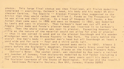
The two inserts that arrived with the first day of issue envelope.  The text was written by Max Lewis, the son of the artist, Alonzo Victor Lewis.  To enlarge the cards and read the text click on the image.


 The Prospector with the Sitka Pioneer Home


Front view of the Prospector, with body of George Washington Carmack


The back view showing all the gear he needed and carried--gold pan, pick axe, shovel, coffee pot, pack,  and staff


Side view


Rifle stock with places carved into the wood


Head of Skagway Bill Fonda

Thursday, October 1, 2015

If this is Thursday it must be postcards, 214


 Wrangell Narrow, S.E. Alaska, ca 1926


 Reverse

The 1926 postcard above shows the Wrangell Narrows in Southeastern Alaska with the photograph taken by John E. Thwaites.  Thwaites was an amateur photographer and a federal government railway mail clerk who traveled on the wooden mail boat, S.S. Dora, between Valdez to Unalaksa delivering mail.   He used a Kodak camera to take his pictures and at some point he realized the potential of the postcard business and sold thousands of his photographic images of Alaska for use on cards such as this one. 

Although the card was sent to I.C. Lee from his friend, John, it is of the same area where my father, Bill Schroder, worked tending fish traps in the mid 1930s.  Fish traps were first constructed in the late 1890s and were still in use into the 1950s although the numbers of traps were diminishing.  There were at one time over 100 fish canneries headquartered in southeastern Alaska; however, the larger companies began buying out the smaller ones and today there are still fish canneries but only a few.  After Alaska became a state in 1959 all the remaining traps were decommissioned.  The fish traps were discovered to be the cause of severe damage to the salmon runs and general fishing in the area.  Today fishing and logging continue to be the mainstays of the Wrangell economy.

When Dad worked there part of his job was to fend off poachers who would steal most or all of the fish in the traps before the canneries could harvest them.  One story that was told about his time working for the Wrangell Fish Packing Company was when he was in his early twenties probably about 1936 or 1937.  A man woke him in the middle of the night and held him at gunpoint.  He was ordered to unlock the fish trap so the poachers could get at the fish.  At about the same time a soap company executive was out on a boat in the strait that night and thought he saw some suspicious activity near the traps.  He took his boat over to get a better look and had also apparently radioed ahead to the local law authorities.  They rescued Dad from the poachers.  The case went to trial even though the poachers threatened to come back and find Dad and kill him if he testified in court.  Dad did testify along with the soap company man and the poachers were convicted.

The 22-mile (35 kilometer) channel is narrow, shallow, and winding with navigational hazards.  About 60 lights and buoys mark the Narrows that run between the islands of Mitkof and Kupreanof in the Alexander Archipelago.  There is also a town named Wrangell at the northwest corner of Wrangell Island.  

The Tlingit people have lived on the island for thousands of years and there are numerous scattered petroglyphs just north of Wrangell.  The oldest non-native settlements on the island were founded by Russian traders who came in 1811 to what is the present-day site of the town of Wrangell.  The Hudson’s Bay Company of Britain started using the Tlingit trading routes under protest by the Tlingits in the mid 1800s.  The native population was severely affected by two smallpox epidemics in 1836 and 1840.  The Hudson’s Bay Company abandoned their fort in 1849 when the stocks of sea otter and beaver became depleted.  The United States built a military post called Fort Wrangell in 1868. 

For more information, please see:


https://en.wikipedia.org/wiki/Wrangell_Narrows
https://en.wikipedia.org/wiki/Wrangell,_Alaska
https://content.lib.washington.edu/thwaitesweb/
http://spo.nmfs.noaa.gov/mfr504/mfr50433.pdf

Thursday, August 6, 2015

If this is Thursday it must be postcards, 206


Tatlanika Gift Shop, Alaska, ca 1980

Bob found this postcard dating from the late 1980s among several others when he was cleaning out some old boxes recently.  The picture of the Tatlanika Gift Shop at milepost 276 on the Fairbanks-Anchorage Highway is from an original pen and ink drawing by Alaskan artist Marybeth Harder.  Notice the Moose antlers above the entrance and at both sides of the building as well as the old snow shoes mounted on the outside wall.  It also looks like a bear hide tacked to the door and at least one blanket handing on the railing.

From what I could discover the items for sale in the gift shop are not the typical cheap trinkets found in many such shops but are instead things made by local Alaskan artisans and of quality.  Another thing that seems to astound campers is that the campground has very clean restrooms with flush toilets and showers both practically unheard of for such an out of the way place. 

The Gift Shop established in 1986 is on the grounds of the small Tatlanika Campground and RV Park that has room for eleven guests and is located near the town of Nenana, Alaska and the Clear Air Force Station, part of the Alaska Air National Guard early warning station.  The Clear station was one of the Alaska World War II Army Airfields later it was converted to a radar station with additional structures constructed in the late 1950s.  Still in use today it has been further modified with the Space Warning Squadron taking on the early warning/space surveillance mission using updated computer processing and software improvements that enhance the capability.

The town of Nenana with a population of about 400 is situated at the confluence of the Nenana and Tanana Rivers.  The Mears Memorial Bridge that spans the Tanana River is 700 feet in length (210 meters) was built as part of Alaska’s railroad project to connect Anchorage and Fairbanks.  At one time this bridge was the longest truss bridge in the United States. 

When Europeans first came to the area they called the town Tortella because they couldn’t manage the native word Toghotthele that means “mountain that parallels the river.”  Russians bartered for goods and furs here as early as 1838.  After the United States purchased Alaska from the Russians in 1867 American explorers and traders began entering this area in the 1870s.  The name was changed to Nenana after the river and the people who lived there.  With the discovery of gold in Fairbanks in 1902 there was an increase of activity.  In 1903 Jim Duke built the first trading post/roadhouse that could supply the natives and the travelers coming though on the river.  It wasn’t possible to tell if the original trading post still stands or if the shop on this postcard is a replacement.

For more information, see:

http://www.romancingalaska.com/interior/INT_tatlanika_campground_%26_rv_park.htm

https://en.wikipedia.org/wiki/Nenana,_Alaska
https://en.wikipedia.org/wiki/Clear_Air_Force_Station
https://en.wikipedia.org/wiki/Clear,_Alaska

Thursday, December 25, 2014

If this is Thursday it must be postcards, 174


A very Merry Christmas to all . . .

Today’s card shows the American version of Santa’s house and workshop at North Pole, Alaska.  North Pole is a small city located southeast of Fairbanks, Alaska; however, a large area within the same postal zip code is referred to as the North Pole even though it is south of the actual geographic North Pole by about 1700 miles. 

The Santa Claus House, a gift shop, shown on the postcard is the biggest tourist attraction in the area.  Originally this was a trading post established in the early days of settlement here.  The world’s largest fiberglass statue of Santa Claus can be found outside the Santa Claus House.  More and more Santa Claus themed attractions have been added throughout the years.  Before Christmas the North Pole post office receives hundreds of thousands of letters to Santa Claus and even more from people who want the town’s postmark on their outgoing Christmas cards.  There is a community program organized to respond to the letters addressed to Santa.  Streets lights are decorated to look like candy canes; streets have names such as, Kringle Drive, Santa Claus Lane, St. Nicholas Drive, and Snowman Lane.  Many local businesses have also adopted Christmas themed colors and decorations as have the local police with patrol cars in green and white, ambulances and fire trucks are all red.  One of the more prominent citizens, Con Miller, became known as Santa Claus because he frequently wore a Santa Claus suit during his early trading days in Alaska.  He served on the city council and was also mayor. 

On the reverse of the card is this message from the North Pole.


For more, see:

http://en.wikipedia.org/wiki/North_Pole,_Alaska

Merry Christmas everyone!

Thursday, October 16, 2014

If this is Thursday it must be postcards, 164


Totem Bight State Historical Park near Ketchikan, Alaska, ca 1960

Originally there was a Native village or fish camp near Ketchikan, Alaska called Mud Bight but the buildings and totem poles fell into disrepair in the early 1900s as the people left to find work in other communities.  In 1938 the Civilian Conservation Corps (CCC) began reconstruction of the site under the direction of Alaskan architect, Linn Forrest.  Skilled Native carvers were hired with the older members teaching the younger ones the art of carving totem poles. 

The plan was for the U.S. Forest Service to salvage and reconstruct as many of these large cedar monuments as possible.  Rotting totem poles were repaired or duplicated.  Every attempt was made to copy the originals in a traditional manner right down to using handmade carving tools.  Samples of the dye colors made from natural materials like clamshells, lichen, graphite, copper pebbles and salmon eggs were then duplicated with modern paints. 

The project slowed down with the advent of World War II but by then 15 totem poles and the community house were in place.  The name of the site was then officially changed to Totem Bight.  Before statehood in 1959 the 33-acre park was under the management of the federal government after statehood it transferred to the Sate of Alaska.  Then in 1970 it was added to the National Register of Historic Places.

There may not have been a community house, such as the one seen in the center of the postcard, when it was called Mud Bight but such houses, large enough to house 30 to 50 people, were typical in many early 19th century Indian villages.  The interior is described as being one large room with a central fireplace.  The floor was smooth wood with removable boards so house wares, blankets and treasured items could be stored below.  Food was hung from the beams and rafters.  Several related families would have lived in such a dwelling with a house chief as the leader.  The totem poles reflected the nature that surrounded the people and told stories since there was no written language.  Totem Bight is generally thought to be Tlingit but there is also evidence of Haida myths and legends in the carvings. 


The postcard was a product of Pacific Northern Airlines which later became Western Airlines in 1967 and then merged with Delta Airlines in 1987.  The stamp is a 7 cent airmail stamp.  Airmail stamps were used within the United States from 1918 to 1975 and internationally until 1995. 

For more information, please see:
http://en.wikipedia.org/wiki/Totem_Bight_State_Historical_Park
http://dnr.alaska.gov/parks/units/totembgh.htm
http://en.wikipedia.org/wiki/List_of_United_States_airmail_stamps

Thursday, August 8, 2013

If this is Thursday it must be postcards, 102


 Shrine Island, Alaska


Reverse


Here is another scenic postcard from Alaska.  This one shows Shrine Island near Juneau and is dated 1949.  No publishing information is available on the card; however, under the handwritten place name the photographers are listed as “Ordway/Neff.” 

Frederick (Fred) K. Ordway (ca 1903-1938) and his wife Laura settled in the Juneau area of Alaska in 1926.  He worked as an electrician for a short period of time before opening his own photo shop—Ordway’s Photo Service.  Ordway was known as “Alaska’s Flying Photographer.”  The Alaska State Library has a collection of 199 of his pictures covering a variety of Alaskan subjects—fishing, whaling, mining, native culture, woodcutting, dog sleds, mountain scenery etc.   Tragically he was killed in a monoplane accident off the coast of Oregon in 1938 at the age of about 35.  He was taking pictures at the time of his death.  His wife, Laura, who was also a photographer and a free lance writer, together with one of their employees, Amy Lou, continued to run the Photo Shop after his death.  Most of the photos taken from 1942 to 1946 with the Ordway credit were actually taken by Amy Lou.  The photograph on the postcard is not dated but it is included in the 199 pictures in the Ordway collection at the Alaska State Library.

Shrine Island was named for the shrine of St. Therese.  The chapel is constructed from local beach stone and is situated in the center of the island.  There are several trails many of hard packed dirt that are wheelchair accessible.  There are also rental cabins available.  Many visitors to the Juneau area are pleased to have the chance to see this lovely spot.  The fishing is excellent here with most of the fish caught King Salmon. 

This Catholic Church was originally built in the 1930s and over the years there have been and continue to be additions and improvements.  In addition to the rental cabins there is also a lodge (1932), a columbarium, (1998), the Merciful Love Labyrinth (2001), the Good Sheppard Grotto and Rosary Trail, and a Pieta statue.  The facility is used as a religious retreat as well as for vacation or recreational stays. 

For more information, please see:

http://www.shrineofsainttherese.org/about-the-shrine
http://www.traveljuneau.com/listings/moreInfo.php?ID=43368
http://beta.worldcat.org/archivegrid/data/55491209

http://books.google.com/books?id=AmsbqOP1TYUC&pg=PA54&lpg=PA54&dq=fred+ordway+photographer&source=bl&ots=icMGOpe8ru&sig=T_YK4qIUBQFRaKkSTpvvmQRV4KQ&hl=en&sa=X&ei=ST8AUrV7z5CKAvrZgfgJ&ved=0CFAQ6AEwBg#v=onepage&q=fred%20ordway%20photographer&f=false