Showing posts with label Marietta. Show all posts

Thursday, June 18, 2020

If this is Thursday it must be postcards, 456


Memorial to the “Start Westward of the United States,” Marietta, Ohio
Sculpture by Gutzon Borglum


Each time I have visited Marietta I have not only walked through the Mound and Oak Grove cemeteries but also walked to Marietta College, where Q taught physics, and along the riverside park.  This statue is one that I have seen and taken photos of several times but had never taken the time to check out its history.  Marietta is filled with history.  Many of the older homes have plaques telling about the original owners and the date the house was built.  The various mounds are identified with plaques also.  There was a brickwork company here and many of the streets are still paved with red brick. 

The unused postcard has a photo by Jayne DeLancey and was issued by Dianne Wehrs Vessa, Inc.  The statue is titled “Start Westward of the United States” and was sculpted from native sandstone by Gutzon Borglum who also made the Mount Rushmore Monument. 

Some of the following historical information has been condensed and paraphrased from the Marietta Masonic Bodies website (see below).  Originally President Franklin D. Roosevelt dedicated Start Westward monument in 1938 as part of the Sesquicentennial founding of Marietta in 1788.  It was rededicated in July 1988 at the closing ceremonies of Marietta’s Bicentennial celebration to the Pioneer Caravan and in memory of Edwin “Zeke” Pugh (1917-1988) who was a member of the 1937-1938 Caravan and Leader of the 1987-1988 Bicentennial Trekkers. 

Following the end of the Revolutionary War the Northwest Territory was open to veterans for settlement.  Both the Mound and Oak Grove cemeteries have Revolutionary War dead graves marked.   The statue features a group of revolutionary and pioneer figures and represents the start of the American Government west of the original 13 states.  At the re-dedication the Marietta Kiwanis Club added flags of the six states, Ohio, Indiana, Illinois, Michigan, Wisconsin and the northeastern part of Minnesota, which were formed from the Northwest Territory with the National Flag in the center.  The Kiwanis also provided permanent illumination of the flags.

The Northwest Territory, also known as the Old Northwest, was formed after the Revolutionary War.  The region was ceded to the United States in the Treaty of Paris of 1783.  Marietta received the first settlers in 1787 and Ohio became a state in 1803.  The area was a vast wilderness populated by Indians and a handful of French colonial settlements when the first settlers arrived.  By 1803 there were dozens of towns and settlements in Ohio. 


Historical marker from 1988

Front and back views of the sculpture


View of the river park paths. The Muskingham River can be seen at the far left.

For additional information, see:

http://www.mariettamasonicbodies.com/start-westward-memorial/
https://en.wikipedia.org/wiki/Gutzon_Borglum
https://en.wikipedia.org/wiki/Northwest_Territory

Thursday, May 22, 2014

If this is Thursday it must be postcards, 143


Fort Harmar, Marietta, Ohio

While in Marietta, Ohio earlier this year we crossed the bridge to what was originally Harmar where this early fort stood.  Today this is part of the town of Marietta.  The postcard is another in a series published by David Shelburne-Shelburne Films for the historical documentary “Opening the Door West”  and available at the Campus Martius Museum in Marietta.

Fort Harmar was built in 1785 by John Doughty (1754-1826).  He was the American military officer who also oversaw the construction of Fort Washington in 1789 on the Ohio frontier.   Fort Harmar was shaped like a pentagon and was situated at the confluence of the Ohio and Muskingham rivers directly across from the Picketed Point Fort featured in a previous postcard Thursday.  The fort was abandoned and later demolished as the development of Marietta expanded.  In 1789 it was the site of the Treaty of Fort Harmar between the United States and several Native American tribes. 

The fort took its name from Josiah Harmar who was influential in the founding of Marietta and had been one of the officers at Fort Harmar.  Even though the village of Harmar has been annexed into the town of Marietta it is still referred to as Harmar and is listed on the National Register of Historic Places.

The footbridge across the river for pedestrians and bicyclers was built next to the rail bridge that is no longer used. The footbridge was interesting because while certainly sturdy enough it is not level nor straight.  Growing near the shoreline and partly in the river were several Silver Maples that can be partially seen at the right side of the photo below. 


Wiggly footbridge 


Sign by the Harmar rail bridge


Harmar historic buildings


Sign by the Masonic lodge in Harmar


Looking across the river from Harmar to Marietta.

For more information:

http://en.wikipedia.org/wiki/John_Doughty
http://en.wikipedia.org/wiki/Fort_Harmar
http://www.OpeningTheDoorWest.com

Sunday, March 30, 2014

Hopewell earthworks -- Marietta Mounds


As mentioned previously, when I travel to Marietta, Ohio I like to take walks and often go through the two main cemeteries, Oak Grove and the Mound Cemetery.  Both have hills but I think only the one at the Mound Cemetery is an actual earthwork.  The Oak Grove Cemetery appears to cover several natural hills.  It is possible to get to the high point in both cemeteries; however, and I did that on this trip.  Last time there was snow on the ground and I wasn’t sure I could get down from the Oak Grove hill without falling, this time it was rainy and wet but Bob helped navigate a safe path and all was well.


Proof that I reached the top of the Oak Grove hill and saw the monument

There are stairs leading up to the top in the Mound Cemetery and it is very peaceful and tranquil up there.  My son and his wife told us that the library is on another mound and nearby was a third mound called Turtle Mound by the locals and used in the winter as a sledding hill. 

Here below are some views of the Conus Mound in the Mound Cemetery.  It rises about 30 feet from the foot to the top, is surrounded by a 15 foot wide, 4 foot deep moat and a berm on the outside of the moat.  From what I read the locality, moat and berm mean that the mound was for ceremonial uses and not a fortification.   It is 585 feet in circumference.


The Great or Conus Mound. 

The staircase and rail are on the left side of the mound.  There are benches and a time capsule on the top.


The time capsule marker


Looking past Commodore Abraham Whipple’s grave toward the Conus Mound and staircase.


Looking from the top down onto the moat and berm that ring the mound.

The Conus Mound was originally a burial mound for the ancient people who lived here and created the mounds.  Today it stands in the center of the Mound Cemetery where many Revolutionary War veterans are buried. 

The mounds are called Hopewell earthworks and we wondered who the Hopewell people were and if more information could be found concerning the mounds and the people who built them.  As it turned out, the name Hopewell came from the European family who owned land where some mounds existed so it does not really apply to the ancient people who built them at all. 

Mounds like these can be found in several states from as far south as Florida to Canada in the north.  There are a number of them in Ohio.  


No one knows for sure who these people were or what happened to their society.  The mounds appear to have been built for specific purposes and are in geometric shapes, rise to impressive heights, and are within a degree or two of seasonal events such as sunrises, moonrises, solstices and equinoxes.  There is some evidence to suggest that there was an extensive trading network throughout the region.  Beautiful and skillful artwork and craft work have been found in some of the graves.


Above is a picture of the library built on the mound called the Capitolium

The other mound we went past several times was the Quadranaou also known as Turtle Mound.


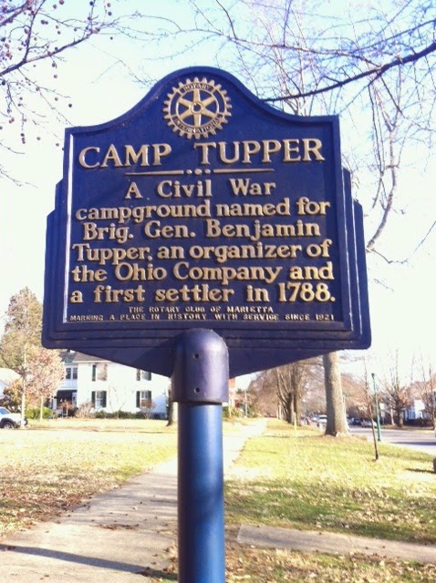
During the Civil War this mound was used as a campground, named after the Revolutionary War Brig. General Benjamin Tupper and therefore has a second marker seen below.   General Tupper is buried in the Mound Cemetery.


Bob found the map below that was prepared in 1838 marking the main earthworks in Marietta.  The early European settlers gave them Latin names:


1.    the Great or Conus Mound, was originally a burial mound, it is the one located in the Mound Cemetery. 
2.    Another of the earthworks was named Sacra Via or the sacred way, a pathway down to the Muskingum River and a large open area that included the Capitolium and the Quadranaou as well as two smaller mounds at the eastern and northern corners. 
3.    The library was built on top of the Capitolium in 1918. 
4.    The Quadranaou is a truncated pyramidal mound with ramps leading to the top.  During the American Civil War it was used as a campground.  It is also the one called Turtle mound.  Research on this mound in the 1990s showed that it was aligned to within two-tenths of one degree with the winter solstice sunset.

All these earthworks are thought to date between 200 BC and 900 AD and could perhaps be older.

For additional information on the mounds and the Hopewell culture see:

http://en.wikipedia.org/wiki/Marietta_Earthworks

http://en.wikipedia.org/wiki/Hopewell_tradition

http://en.wikipedia.org/wiki/Mound_Cemetery_%28Marietta,_Ohio%29

Special thanks to Lou for taking and sending additional pictures of the mounds.  The Sacra Via is the only earthworks on the map that I have not seen in person.  On the next trip to Marietta we hope to visit it. 

Thursday, December 12, 2013

If this is Thursday it must be postcards, 120


Fort Frye, near Beverly and Waterford, Ohio

Here is another winter scene postcard.  The card is a modern card produced by David Shelburne Films with the image from the award winning documentary “Opening the Door West.”  [see:   www.OPeningTheDoorWest.com]

The original Ohio Company was founded about 1748 by a group of Virginian explorers as a land speculation company to extend settlement in the colonies and foster trade with the native population.  The company had a land grant from Britain and it was hoped that settlement would help block French expansion into the territory.  The name was later changed to the Grand Ohio Company with a land grant along the Ohio River.  A colony called “Vandalia” was to be established there but the American Revolutionary War interrupted colonization and it was never achieved.  After the Revolutionary War in 1786 the company regrouped as The Ohio Company of Associates.  The new company was comprised of mostly New England veterans who had been given certificates for land from Congress for their military service.  Many Revolutionary War veterans settled in the Northwest Territories as a result.  The Mound Cemetery in Marietta, Ohio has a large number of Revolutionary War veterans buried there.  The graves are located throughout the cemetery but there is also a group memorial section shown below.


Revolutionary War memorial, Mound Cemetery, Marietta, Ohio

Fort Frye was built by the Ohio Company of Associates in 1791 near the settlements of Beverly and Waterford located on the Muskingum River about 20 miles up river from Marietta.  It was constructed at the beginning of the Northwest Indian War following a massacre at another settlement, Big Bottom.  The fort was meant to provide some protection for the settlers. 

Unlike most forts of the time this one is triangular in shape instead of square or rectangular.  The reason given for the shape was that the Ohio Company was in a hurry to get the fort built and this shape with the block houses placed at angles offered as much protection and allowed them to essentially cut off one side saving time and expense.  The picture on the card shows the base of the triangle running along the riverside with the line of pickets or palisades 12 feet high surrounding the fort and extending to the water’s edge.  There were strong, broad gates near the northern block house that led out to the fields and the main road.  More or less opposite the northern gate was a second, smaller gate, called the “water gate” that offered access to the river and provided a way to escape by boat if necessary.

At each of the fort corners was a two-story block house with dwelling houses lining the longer sides.  In between the buildings were defensive pickets.  Some of the roofs were single sided so that rain would fall into the garrison and presumably into a cistern or water barrel.   The fort was named after its builder, Joseph Frye, and used between the years 1791 and 1795.  The commander was William Gray.  During the Indian War these other forts were also constructed in this area along the Ohio and Muskingum rivers:  Fort Harmar, Campus Martius, Picketed Point Stockade, and Farmer’s Castle.  Farmer’s Castle is near Belpre, Ohio the others are in or closer to Marietta.  


The Campus Martius Museum in Marietta has displays of the local native culture including this wall with illustrations of some of the more prominent inhabitants during the 1700s and early 1800s.


For additional information and pictures, please see:

http://en.wikipedia.org/wiki/Ohio_Company
http://en.wikipedia.org/wiki/Fort_Frye

Saturday, March 23, 2013

Oak Grove Cemetery, Marietta, Ohio


 Entrance to Oak Grove Cemetery

Oak Grove is the other cemetery that I passed on daily walks.  It is a large cemetery comprised of 33 acres, covering a hilly area in the town of Marietta, Ohio.  I walked up the hills and around the hills and wanted very much to get to the top of the main hill where there was a monument of some type but it had been snowing, the ground was slippery, no stairs or paths led up to the top, and it was steep so while I was fairly confident I could climb up to the top I was worried about getting back down without falling or slipping.  After I returned home my son and his wife did climb up to the top and took a couple of photos for me. 


Q standing by the monument at the top of the hill Oak Grove Cemetery


The front of the monument erected for the 50th anniversary of the founding of the cemetery


The plaque says in part:  “50th Anniversary of Oak Grove Cemetery, 1860 Mayor 1910 William A. Whittelson, Solicitor Franklin Buell, Clerk John Tash (?), Treasurer John A Grimm (?), Civil Engineer Alexander L. Haslun.  Council—1st Ward, 2nd Ward, 3rd Ward” with names not clear enough to read.


Views from the top of the hill

The town purchased land for the cemetery in 1860 or 1861 with the first two burials being little children.  The first adult buried here occurred in 1864.  I did see one poignant tombstone that simply said “Little Maude” infant daughter of . . .” with the date.   Many of the stones are so old and made of limestone so the inscriptions are either worn or covered in moss and lichen making them at times difficult to impossible to read.


Unlike the Mound Cemetery this one does have an office and also a mausoleum and this other building above that looked as if it may have at one time been a small chapel.  The grounds are nicely kept but the road and path surfaces could use a little help as is evident from the picture at the top.  Many of those buried here are Civil War veterans but there are few of the Revolutionary War star markers as well. 


The size of this cemetery in such a small town is amazing.  Although I meandered around several times taking different routes I never did walk the entire grounds. 


This view gives a little bit of an idea of the hills and also the snow was still on the ground in places. 


There were labels by some of the trees including this large Hickory tree.  Elms and Hickories are not common in the Northwest yet references to them often appear in books so I was curious and a bit sorry that the leaves were not yet out so I could see what the tree would like in its “summer dress.” 


The Grand Army of the Republic (G.A.R.) is an organization that Civil War veterans and their descendants can join.  Thomas LeRoy Ford who was the husband of Margaret (Maggie) Lorig, was a member as was his son Ralph Ford. 


Civil War graves

Tuesday, March 19, 2013

Mound Cemetery, Marietta, Ohio


Mound Cemetery, Marietta, Ohio

While in Marietta, Ohio I took walks almost every day.  Some of the walks ended up being more than 4 miles and were a surprise to me since it did not feel like I had walked that far.  There are two cemeteries that I often passed when walking, the Mound Cemetery and the Oak Grove Cemetery.  The Mound Cemetery is so named for the ancient Hopewell mound located there.  The mound is known as the Great Mound or Conus.  It is thought to date from 100 BC to 500 AD.   As noted in the postcard Thursday last week Marietta was founded in 1788 as the first settlement in the Northwest Territory.   The land for the cemetery was donated by General Rufus Putnam in January 1801 with the first burial taking place that same year in October. 


Informational placard


The placard gives a brief history and has a key to the graves of important people buried there including Revolutionary War veterans. 

It is a rather pleasant, quiet place to stroll around.  The mound has stairs to the top and benches to sit on once one is up there.


The mound

Revolutionary War officers and soldiers were the pioneers of Marietta most coming from Massachusetts.  Land grants were given to veterans as payment for military service.  The Daughters of the American Revolution publication of Jan-Jun 1900, American Monthly, stated that there are more officers of the Revolution buried in the Old Mound Cemetery than in any other place in the United States.  A small section with flags and memorial stars has the names of several Revolutionary War veterans.  


Flags and Stars with names of Revolutionary War veterans


Close up of a star

The French General, Lafayette, visited Marietta in 1825.  He had fought with the Americans during the Revolution and a quote from him is engraved on one corner of the cemetery:  “I knew them well.  I saw them fighting the battles of their country . . . They were the bravest of the brave.  Better men never lived.”


Views from the top of the mound


The cemetery is fenced, not very large and is situated in the middle of a residential area.   For more information and photos:

http://familytreemaker.genealogy.com/users/n/i/t/Debra-Nitsche/FILE/0157text.txt
http://www.forgottenoh.com/Cemeteries/mound.html
http://en.wikipedia.org/wiki/Mound_Cemetery_%28Marietta,_Ohio%29

Thursday, March 14, 2013

If this is Thursday it must be postcards, 82


Campus Martius

As some of you know I just returned from two weeks in Marietta, Ohio where I was visiting with my son and his family.  While there I went to the Campus Martius museum where I found this postcard showing the Northwest Territories first settlement in Marietta constructed during the winter of 1788-1789. 


Sign in front of the museum


The Campus Martius museum building

The museum is built around the home of General Rufus Putnam who was in charge of the settlement.  The fort housed about 50 men and the Putnam family.   Men who had served in the Revolutionary War were given land grants in what was being called the Northwest Territories as payment for their military service.  Many of the houses in Marietta today have plaques telling the history of the home and the name of the original owner.   On my daily walks I would take time to read some of these plaques and also to visit the Mound Cemetery where several Revolutionary War veterans are buried. In a future post I will put up some photos of the cemetery and a little more information.

 
The bell said to have been gifted to the town of Marietta by Marie Antoinette of France.
 
 
The town of Marietta is named after Marie Antoinette of France and the story is that she gifted a bell to the town.  That bell is currently displayed at the museum in the reconstructed Putnam house.  Here below are some photos of the Putnam house.


The living room or parlor of the Putnam House
 

The kitchen in the Putnam house


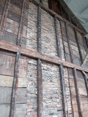
A section of the exterior wall of the Putnam house to show the construction method.


There is a PBS documentary called “Opening the Door West” that has more images.  Visit www.OpeningTheDoorWest.com for more about this award winning program.