Friday, May 28, 2021

Chiwaukum Creek, 2021


Trail signs


The most recent hike we did was Chiwaukum Creek, Wenatchee National Forest in eastern Washington.  It takes about 2 hours to drive from the city to the trail head.  Since folks always ask, yes, there is an outhouse at the trail head.  It was sunny and already getting warm when we parked.  A Forest Service Pass is required, such as the Northwest Forest Pass, or for retirees there is a one time only fee for a Senior Pass called the America the Beautiful National Parks and Federal Lands Pass.


The trail follows along Chiwaukum Creek for part of the way


Some of the burned trees have been topped leaving tall snags or stumps


Other burned trees will eventually weather to a white color and become "ghost trees" 


This area is renowned for its wildflowers including some that only grow there.  This is peak bloom time and we hoped to find some favorites.  There was a fire in 2014 that destroyed hundreds of trees.  The last time we hiked here was before the fire and we were not sure what the forest would look like or if much of the low growing plants had survived and been able to grow back.  Also, the day continued to get warmer as we progressed along the way.  Eastern Washington gets more sun and can be considerably hotter than the western side of the mountains making shade a coveted commodity. 


Because there were not many trees left to provide any shade, we were not able to hike as far as we had hoped.  Our original goal was a 5-mile round trip with a 500 ft elevation gain.  It did not appear that many people had been hiking on this trail since the fire.  We met only one other person, a young man backpacker, who was returning from a 3-day camping trip.  He gave us a report on snakes (he put on gators after finding a baby rattlesnake), bears (he encountered one at a safe distance and set up a motion sensor in his tent just in case it got too close), he also saw deer and elk.  He mentioned that the conditions of the trail and forest ahead were a bit worse.  There was a downed tree about one or two miles ahead of where we met him and he advised turning around if we made it that far.  He had had difficulty climbing over the tree, couldn’t see a way around it, and thought it would probably be a bit risky for us to try.  As it turned out, we did not get that far.  The temperature had climbed to almost 80 degrees F in the bright sun and both of us were feeling the heat.  In the end we went 3 ½ miles RT, which felt like a lot longer, with a 350 ft elevation gain. 


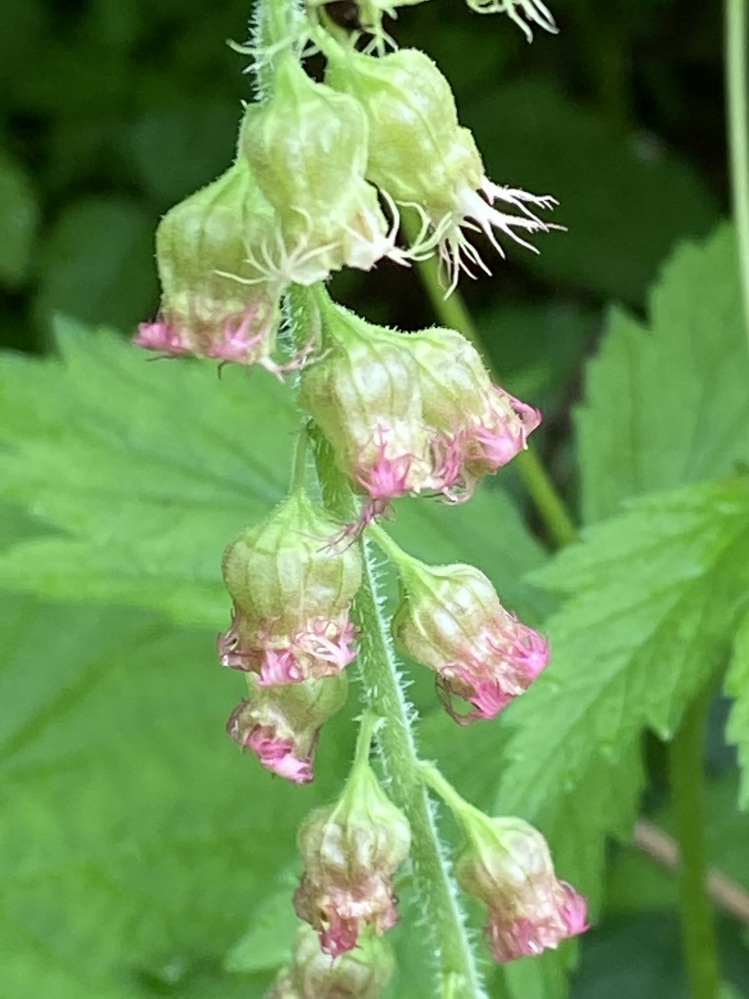
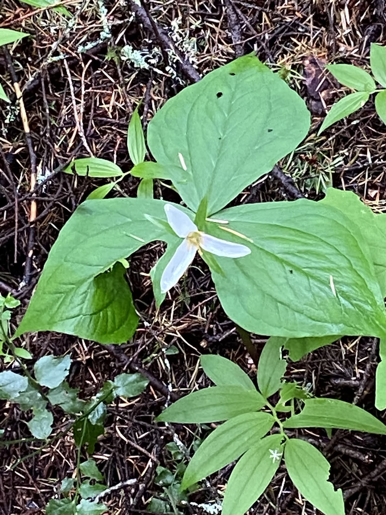
While not many of the trees had any life left from the fire, the undergrowth was coming back and many of the flowers we hoped to find we found.  Both of us remembered finding Tweedy's Lewisia flowers at the first switchback from our previous hike before the fire, but they were not there this time.  We later found several patches of it further along the trail.  In all we counted over 30 different kinds of flowers.


 Yellow Salisfy


Heartleaf Balsamroot


Mertensia


Indian Paintbrush


Lupine


Penstemon


Rockslide Larkspur


Serviceberry aka Saskatoon


Snowbrush


Wild chickweed sometimes called Prairie flower


Vine maple flower 

Have you ever wondered what a maple bat flower looks like?  This is it.  Very tiny and delicate. 


Bald Hip Rose


Tweedy's Lewisia


Count for the day:  1 backpacker, no dogs, lots of non-biting small insects


Stan's Overlook, Rattlesnake Mountain, 2021


The sign right at the beginning of the trail


 There are a couple more signs along the trail including this one posted just before reaching Stan's

We have been to Stan’s Overlook three or four times.  The last time we went so much foliage had grown up that the view was non-existent.  This time the first thing I noticed was that the brush had been cut and the view was back!  This hike is fairly close to the city making it popular.  There is a picnic table at Stan’s and a couple of benches facing toward the territorial view. 


Territorial view from Stan's Overlook

Stan’s is a 5 miles RT, with a 1050 ft gain.  The temperature was cool and it was cloudy with some sun making an ideal hiking day.  In addition to the hiking trails this area also has mountain biking trails.  We could hear the bikers in places but could not see them except where the two paths crossed.  The trail crew has installed “gates” at the crossings and signs showing which trails are for hikers only.  Originally gates were necessary to keep the bikes and horses off the hiking trail; however, the new bike trails have removed the temptation.


This was the only section of stairs. 


Scotch Broom blooming in the meadow by the power lines


Close up of the red and yellow Scotch Broom blossoms


One of the gates on the hiking trail


We take our time for photos, and watch for flowers and wildlife.  We saw lots of Vanilla Leaf, Fringe cup, Fairy Bells, Trillium, Elderberry, and, while an invasive still pretty, Scotch Broom including the red-yellow version.  There was some birdsong but we did not see birds or animals. 


Fringe Cup


Trillium and Starry Solomon Seal


Elderberry


Fairy Bells


Vanilla Leaf


As Bob points out despite its name, there are no snakes on this mountain.  The Discover Pass is required.  The trail head has an outhouse.  The Snoqualmie Point Park, a short stop away from the trail head, has a public restroom with flush toilets and running water.


Count for the day: 5 miles RT, 1050 elevation gain, 23 hikers, 7 bikers, and two dogs.   


Garfield Ledges, 2021


Sign at the start of the Garfield Ledges trail

Garfield Ledges was a new hike for us on a new trail completed in 2019.  That said, it is short, a little more than 1 mile with an 800 ft elevation gain.  We were looking for something that would provide about a 4-mile round trip.  The solution?  We parked at the Middle Fork Snoqualmie trail head and took a connector trail along the Taylor River.  This was a little less than one mile of level terrain with plenty of views of the river and the pleasant sound of rapidly running water all along the way.  The trail crew has cut several log chairs and placed them at the various view points along the river.  Large stumps that have now become nurse logs for new trees are evidence of logging done here between 80 and 100 years ago. 


Large stump of previously logged tree that has now become a nurse log with trees growing on top.


Along the Taylor River on the connector trail.  Just across the bridge is the trailhead and picnic area for the Garfield Ledges trail.


The forest floor and the trees covered in moss on the connector trail.


There are several of these benches cut from downed trees along the connector trail where there are viewing areas.

The connector trail ends at the car bridge over the river and the Garfield Ledges trail head is immediately past the bridge.  Both the Middle Fork Snoqualmie and the Garfield Ledges trail heads have picnic tables with river views and outhouses.  While the trail along the river was level the Ledges trail starts right off with a steep grade.  The trail ends at the view point. There are about a dozen switchbacks and 75 stairs to climb before one reaches the top.  But the hike up was well worth it.  The territorial view from the top is spectacular!  Looking west is the Middle Fork Snoqualmie valley rimmed by mountains with the Taylor River far below in the foreground.  This was the steepest and more elevation gain I have attempted since my broken ankle and the onset of the pandemic. 


Bob admiring the view once we made it to the top.


View from the top of Garfield Ledges

There were a few trilliums, lots of bleeding heart, Oregon grape, and some Salmon berry blossoms.  We heard birds but didn’t see them, one Douglas squirrel briefly posed for a photo.   


A Douglas squirrel poses


Oregon grape


Trillium


There were many large patches of Bleeding heart along the river portion of the trail.

 Note:  The Forest Service Pass is required. 

Count for the day: 4 mile RT, 800 ft elevation gain, 9 hikers, no dogs. 


Thursday, May 27, 2021

If this is Thursday it must be postcards, 505


National folk costumes from Bohuslän, Sweden 


This is an Åredal Fotoproduktion unused postcard with a photograph by Stig Årendal showing two different costumes, the one on the left from Fräkne and the one on the right from Bohus.  The identifying code, D27, is found on the center line on the reverse of the card.  At the bottom left on the reverse is a flag outline with “Svenska folkdräkter” printed across the center line.  The card is undated.


Like Norway, each different area in Sweden has its own folk costume.  The costumes are similar in the two countries but have some differences.  The Swedish aprons appear to be a little longer, here one is made of patterned material, the other is plain.  While there is trim on the blouses and the bodices, there does not seem to be as much embroidery work as is found on the Norwegian costumes.  The two costumes represented on the card come from Bohuslän a province on the northern part of the west coast of Sweden.  It is located across the border from the Norwegian county of Østfold.  Bohuslän, formerly Baahuslen, when it was a Norwegian county, is named after the castle of Bohus.  This area was part of Norway from the 870s until the Treaty of Roskilde in 1648 when the union of Denmark-Norway was forced to cede it to Sweden.  Bohus and Gothenburg were merged in 1998 and have become the larger Västra Götaland County.


Geographically Bohuslän has a rocky coast and includes about 3,000 islands.  In the past there were many shipwrecks on the reefs and sunken rocks along this coast.  Most of the coast is made up of Bohus granite.  Unlike other parts of Sweden there are few streams and lakes in Bohuslän. 


This area of Sweden is also known for Nordic Bronze Age, 1700 -500 BCE, rock art.  Near Tanum, in Bohuslän, there is a museum, a visitor center, and a site where there is an incredible example of the Vitlycke rock art.  There are scenes from daily life of that time period, also religious rituals, and animals that were hunted.  When we were in there in 1982, I picked up a little booklet about the Vitlycke rock carvings but no postcards!  I have postcards from other places we visited on that trip, so perhaps the booklet was the only thing I could find at the time.  The main carving is a group that measures 22 ft by 68 ft. and contains at least 400 figures.  All the carvings at Tanum are found on slabs of rock on hillsides near running water. 


Near Tanum, Sweden, 1982 


A picnic lunch in the foreground, the visitor center at the mid-left, and the rock art slab on the hillside.  There is a small stream of water that crosses the slab as well as a larger brook or stream with a small bridge.  Of course, the adventure would not be complete without one of these three children falling into the water while trying to catch a frog.


A section of the main grouping of the rock art, 1982


This is now a UNESCO heritage site.  The museum has been enlarged and the grounds include examples of how the people lived and what the houses looked like.  

For additional information, see:


https://en.wikipedia.org/wiki/Bohuslän

https://en.wikipedia.org/wiki/Bohus_Fortress

https://www.vastsverige.com/en/tanum/produkter/vitlycke-museum/


Thursday, May 20, 2021

If this is Thursday it must be postcards, 504


Three Rhine bridges with cathedral tower, Basel, Switzerland


This unused postcard distributed by Hans Frey of Basel, Switzerland, has a photograph of three bridges crossing the Rhine River in Basel with part of the cathedral tower in the foreground.  The card has the number 547 printed in the bottom center margin on the reverse. 


The third most populated city in Switzerland after Zürich and Geneva, Basel is a city located in northwestern Switzerland on the river Rhine.  Considered the cultural capital of the country it is famous for its many museums.  Basel University, the oldest university in the country, was founded in 1460. 


Originally a Catholic cathedral the Basel Minster is a Reformed Protestant church today.  Architecturally it is in the Romanesque and Gothic styles and was built between 1019 and 1500.  In 1356 an earthquake destroyed the late Romanesque building and it was rebuilt by Johannes Gmünd.  The southern tower was completed in 1500 by Hans von Nußdorf.  The exterior is red sandstone and the roof has colored tiles.  It is one of the main landmarks and tourist attractions in Basel. 


The bridge seen closest to the cathedral is called the Middle Bridge and is located on the oldest existing bridge site across the Rhine.  In 1903 and 1905 the old bridge was renovated and rebuilt entirely out of stone.  At that time, it was named the Middle Rhine Bridge.  Prior to that the bridge was called the Rhine Bridge.  At the time it acquired the Middle Bridge name it was one of three bridges spanning the river and found between two other bridges.  Constructed of granite the bridge is about 630 ft or 192 m long and 59 ft or 18 m wide.  In 2002 the bridge was refurbished but no alterations were made to its appearance.  As part of the car free city center the bridge has been closed to private motor vehicles since 2017.


For additional information, see:


https://en.wikipedia.org/wiki/Basel

https://en.wikipedia.org/wiki/Basel_Minster

https://en.wikipedia.org/wiki/Middle_Bridge_Basel


Thursday, May 13, 2021

If this is Thursday it must be postcards, 503


The Prime Minister Michelsen welcomes the King aboard “Heimdal,” 1905 


In a few days it will be time to celebrate Syttende Mai!  Also called Norwegian National Day or Norwegian Constitution Day held annually on 17 May.  The postcards shared this week were sent Petra Landaas Lee.  The cards were part of a 5-postcard set sent to Petra by relatives or friends in Bergen, Norway at the time it separated from Sweden.  This set of cards was distributed by Eneberettiget John Fredrikson’s Eftf, Kunstforlag of Christiania (Oslo).  The photograph shows the new King, Haakon VII, holding his son, the Crown Prince, Olav and shaking the hand of the Prime Minister, Chr. Michelsen. 


 Note to Petra on the 5-postcard set flap, 1906


An unsigned message penned on the inner fold of the card set says: “Mom and Dad send their heartfelt greetings and thanks for the photographs and cards to you and your husband.  Here you greet your ancestors (relatives).”  The postmark is dated 17 January 1906.  The printed date on the series of cards is 25 November 1905.


In the 1380s, when Olaf II of Denmark inherited the Kingdom of Norway at the death of his father, Haakon VI of Norway, until 1814 Norway and Denmark were linked together in a union sometimes referred to as the Twin Kingdoms.  Each country had its own laws, currency, and armies.  Since Denmark was mainly agricultural and Norway had an export-driven economy the countries balanced and benefited each other.  As a result of the defeat of the combined union of Denmark and Norway during the Napoleonic Wars, the union was dissolved.  In the hope that Norway could avoid being ceded to Sweden the Norwegian Constitution, declaring Norway to be an independent kingdom, was signed on 17 May 1814 at Eidsvoll.  However, at that time Norway was still legally in a union with Sweden.  Instead of becoming its own country Norway now was in a union with the King of Sweden, who became the King of Sweden and Norway.  It was not until 1905 that Norway peacefully separated from Sweden and became, at last, an independent country with its own monarchy. 


King Haakon VII, shown on the card, was born Prince Carl of Denmark, the son of Frederick VIII of Denmark and Louise of Sweden.  He chose to take the old Norse name Haakon and became the first independent Norwegian monarch since 1387.


King Haakon VII and Queen Maud, 1905 


Queen Maud, Prince Olav, and King Haakon VII, 1905 arriving in Kristiania now Oslo 


Seattle, and particularly the Ballard district of the city, is known to have a large Scandinavian-American community.  Each year there is a 17th of May parade held in Ballard where many people wear the traditional Norwegian costumes and wave Norwegian flags, enjoy music and entertainment.  A commemorative pin is issued each year.  The proceeds go to help fund the parade and associated events. This year's pin is shown below.


For additional information, see:


https://en.wikipedia.org/wiki/Haakon_VII_of_Norway

https://en.wikipedia.org/wiki/Consitution_Day_(Norway)

https://en.wikipedia.org/wiki/Denmark-Norway

https://en.wikipedia.org/wiki/History_of_Oslo’s_name

https://www.visitoslo.com/en.articles/history/

https://www.17thofmay.org/