Thursday, April 30, 2020

If this is Thursday it must be postcards, 449


Årstad Church, Hordaland, Norway, ca 1900
[from:  Årstadposten, 24 August 1993]


This postcard of the Årstad Church was published in Årstadposten, issued dated 24 August 1993.  Norvald Halland who helped with other information involving the Landaas family that subsequently ended up in the A Family Gathering: Landaas* book published last year, very kindly found the article and forwarded it on to me recently.  


 The stone church, as it looks in the picture, was built in 1890 and seats about 560 people.  Some of the Landaas family members were christened at Årstad in the 1840s.  However, since that was prior to 1890 there must have been earlier church or the parish could have met with another parish in the area and shared a different building.  The card itself has a black and white photograph that has been tinted with color. 

It was delightful to get this new information that not only included the postcard but a photograph of the area taken in 1920 and a line drawn map from 1934 with additions made in 1949, showing where the farm was located.  All this area is now part of greater Bergen.  The outline map from Wikipedia, below, shows each borough or district that once was separate and is now included in one "county" called Bergen.  During the Viking era it is said that all of Årstad belonged to the king of Norway. It is also believed that one of our early Landaas ancestors received land for his service to the king.  Lakesevåg and Fana are other places associated with the Landaas family and this outline helps to show how close the communities are to the city of Bergen and to each other.  The communities of Lysekloster and Os, where the Landaas family also had connections, are further south.


Line map showing the communities near Bergen, Norway
[from:  Wikipedia.org]


Farms and houses in Årstad, in 1920, photo from the University of Bergen library, Norway
[from:  Årstadposten, 24 August 1993]


 Årstad, south of the city center, was merged into the city of Bergen in 1916.  The boundaries are similar to the old municipality.  The population in 2014 was almost 40,000.  The farm Øvre-Landaastræt, where Mikkjel Johannesen Øvre Landaastræt and Kari Pedersdatter Fiskeset lived after leaving Fiskeset is highlighted in green on the photo, above.  On the map below, the upper green inset is Øvre Landaastræt, the larger yellow inset also includes Landaas Hovegård, in the middle, and Nedre Landaastræt at the bottom of the inset.


Line drawn map with with insets added has farms and houses indicated, 1934, updated 1949
[from:  Årstadposten, 24 August 1993]


Below:  The parents of Peder Landaas.  These were the grandparents the Landaas children often stayed with during the summers.  Peder's two older girls, Mikkeline and Petra, had the task of watching the goats and sheep on the hillside.


Mikkjel or Mikkel Johannesen Øvre-Landaastræt  (1812-1885)
[found on Ancestry.com]


Kari Pedersdatter Fiskeset  (1818-1908)
[found on Ancestry.com]

I especially wanted to include this card and the additional photos plus the maps in the blog since I know some extended family members will be interested.


With many thanks to Norvald Halland in Norway for sending the link and sharing the card, the pictures and the maps.

For more information, see:

https://en.wikipedia.org/wiki/Årstad_Bergen
https://en.wikipedia.org/wiki/Årstad_Church
http://www.arstadposten.no/2019/01/12/se-kart-og-bilde-over-landas-gardene-for-utbyggingen/


-------------------------------------------------------------------------------------------------------------------

*  The original plan was for each branch of the extended family to have its own book.  At this time 4 volumes are completed and there are still at least 3 more in the Family Gathering series in the works. As I have published each volume in the series it has become evident that there will be a need for an extra book for corrections and additions once the set is completed.  [Note:  The books are available by invitation only.  Family members who would like to order a copy can contact me privately and I will send the information.]


 Cover of the Landaas family book, 2019


Thursday, April 23, 2020

If this is Thursday it must be postcards, 448


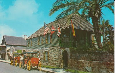
The Oldest House, St. Augustine, Florida

St. Augustine is located on the northeastern coast of Florida.  The Oldest House, also called the González-Alvarez House, is shown on this unused postcard.  The card, distributed by Florida Souvenir Co., of St. Augustine, has the number 49987 at the center bottom of the reverse side.  The photographer is not identified.  There is an information blurb at the upper left corner on the reverse:  “The Oldest House, St. Augustine, Florida constructed in the late 1500’s, this ancient Spanish house is an outstanding example of Old World historical preservation.  Open to the public as an historical museum.”  It is hard to tell how old the photograph might be; however, more recent pictures indicate that the “stars and bars” flag of the confederacy is no longer displayed on the building.

The two-story house is located in a residential area south of the downtown.  The first floor is built of coquina limestone, a sedimentary rock composed of fragments of mullusk, trilobite, brachiopod, and other invertebrate shells.  The word “coquina” comes from the Spanish word for shellfish or cockle.  The upper floor is wood framed with a clapboard exterior.  The hip roof is finished with wooden shingles.  Multiple alterations and enlargements have been done at different times since the original construction.  There is a discrepancy in the dating of the construction with the postcard blurb dating the house in the 1500’s; other sources show 1625, and the oldest documented portions of the current structure dates from around 1723.  It was built in the Spanish colonial architectural style with later modifications by English owners.

The first people to live in the house were members of the family and descendants of Tomas González y Hernandez and Maria Francisco de Guevara (1625-1763).  In 1763 the British took over Florida and the Gonzáles family left for Cuba.  An Englishman, Major Joseph Peavett, purchased the house in 1774 and added the wood-frame second floor, put in glass windows where the openings had only had wooden shutters previously.  The third owner, Geronimo Alvarez, added a two-story wing built of coquina.  During the years from 1882 to 1918 the house changed hands several times and was even the home of the South Beach Alligator Farm from 1911 to 1918.  In 1918 the St. Augustine Historical Society took over the property and undertook a restoration in 1959-1960 that reversed a number of earlier alterations and left the building appearing as a late 19th century structure.

Thick walls help to provide insulation from hot weather, an open, covered loggia, or open corridor, allowed the wind to circulate aiding cooling in the building.  The interior floors are made of tabby concrete, a mixture of lime made from oyster shells, broken oyster shells, sand, ash and water. 

For additional information, see:

https://en.wikipedia.org/wiki/González-Alvarez_House
https://en.wikipedia.org/wiki/Coquina
https://en.wikipedia.org/wiki/St._Augustine_Florida
https://en.wikipedia.org/wiki/Loggia
https://en.wikipedia.org/wiki/Tabby_concrete

Thursday, April 16, 2020

If this is Thursday it must be postcards, 447


Old horse drawn wagons in the collection of Lambert Florin, Portland, Oregon


Byron Larson of Portland, Oregon is the photographer and the publisher of the deckle edged postcard shared this week.   The card was distributed by Princess Continental and has the number 131360 and a logo in the place where the stamp is to be affixed on the reverse.  Deckle edges were popular from the 1930s to the 1950s with some showing up even into the 1960s.   There is an informational blurb at the lower left corner on the reverse explaining that these horse drawn vehicles were part of the atmosphere of the Old West.  They are part of Lambert William Florin’s collection of items from the early American West.

Beginning at the left side of the card is a successor of the buckboard and is called a spring wagon.  The spring wagon has four wheels and was drawn by draft animals, usually horses.  It had a square box and two to four movable seat boards.  The seat in the photo looks like a luxury model.  It was called a spring wagon because it had a spring-loaded gate and the box body was hung on platform springs, front, rear, or both.  It was used as a delivery van.

The next vehicle is a sulky.  It had two wheels, was a lightweight cart, and had a seat for the driver.  It could be pulled by horses or dogs and was used in harness races.  Another form of the sulky was used as a form of rural transportation. 

The third wagon, blue and white, in the photo is a regulation horse drawn mail wagon first introduced in the 1870s.  These wagons were often embellished with painted eagles, decorative trim and red, white and blue stripes.  Before automobiles these mail wagons were used for local mail deliveries.

The fourth wagon on the card is the familiar covered wagon or Conestoga used by “overlanders” migrating westward.  They could be pulled by horses, mules or oxen.


This old Schroder family photo, above, taken about 1914, shows a couple, with the woman holding a baby, riding in a wagon similar to what many people of that era would have used. Not a buckboard or spring board but slightly fancier.  Written in the album margin was "the old hosh [horse] shay," like the poem about the one horse shay; although, this one has two horses.  The seat bench looks like it is made of wicker.  "How do you suppose women in those long dresses got up into the wagon?"  I asked Bob, thinking there might be a stool or folding step.  He suggested that they either had to "claw" their way up or get help from a man.  

The collector, Lambert William Florin, was born in Oregon in 1905.  When he was a teenager he worked at a number of odd jobs, as a cook, a fisherman, a busboy, and also working on a gladiola farm.  In 1923 he moved to San Diego, California where he worked in the florist business for the next 18 years.  Alcoholism caused the collapse of his marriage, loss of his job, and ill health brought a return to Portland, Oregon where he was active in Alcoholics Anonymous for many years.

Florin worked for the U.S. Forest Service as fire lookout.  He was also a substitute firefighter for the Portland Fire Bureau.  He climbed nearly ever peak in the West at least once.  He also worked for several local florists.  He became interested in ghost towns and photography.  He wrote and illustrated 14 Western Ghost Town books in a series.  He was a collector of Early American West memorabilia, minerals and gems.  He also cultivated roses and had a large collection of orchids.  He died in Portland, Oregon in 1993 at the age of 88.


The logo at the upper right corner on the reverse shows a K in a diamond shape with a crown and includes the identifying number. The K in the diamond logo appears on other cards and until this one distributed by Princess Continental that logo had remained a mystery.

For additional information, see:

https://www.findagrave.com/memorial/107365669/lambert-william-florin
https://www.britannica.com/technology/spring-wagon
https://en.wikipedia.org/wiki/Covered_wagon
https://en.wikipedia.org/wiki/Sulky
http://www.uvm.edu/landscape/dating/mail_service/mail_wagon.php

Thursday, April 9, 2020

If this is Thursday it must be postcards, 446


El Divino Pastor (fragment) by Murillo, 1660

Since Easter is this coming Sunday it seemed a good time to share this unused postcard showing a fragment of the painting titled “El Divino Pastor” or “The Good Shepherd” by the Spanish artist, Bartolomé Esteban Murillo (1617-1682).  The card is identified as a product of Ediciones Barsal, Barcelona and has the number 11 at the lower left corner of the reverse. 

The original painting is displayed at the Prado National Museum in Madrid, Spain.  The Spanish Baroque painter, Bartolomé Esteban Murillo, is best known for his religious pieces but also produced a number of paintings of women and children that depicted everyday life of his era.  The paintings include realistic portraits of flower girls, street urchins, and beggars that provide a record of what life was like.  

The original oil painting of Jesus as the shepherd boy with a lamb measures 63” X 48” (161.00 cm X 123.00 cm) and is dated 1660.  Murillo was not only a successful religious painter, his gift for painting children, especially the Infant Christ and the Infant Saint John the Baptist, made his works sought after by both Spanish and foreign collectors.  Many of his works are still among the most widely produced.  In the painting on the card he provides a glimpse into everyday life with a child and animal and at the same time illustrates the sacred subject, the Lamb of God.  

Murillo was the youngest of 14 children.  He was about 10 years old when both his parents died and he became a ward of his sister’s husband, Juan Agustin Lagares.  Instead of using his father’s surname he used the surname of his maternal grandmother, Elvira Murillo.    He was not the only artist in his extended family and began his studies with a relative, Juan del Castillo.  His uncle, Antonio Perez was also a painter. Murillo had many pupils and followers and at one time his work was better known than any other Spanish artist.  Public collections of his works can be found in several different museums including the Prado Museum in Madrid, Spain; the Hermitage Museum in Saint Petersburg, Russia; Timken Museum of Art in San Diego, California; and the Krannert Art Museum in Champaign, Illinois as well as others.

For additional information, see:

https://en.wikipedia.org/wiki/Bartolomé_Estaban_Murillo
https://www.theartstory.org/murillo-bartolome-esteban/artworks/

Thursday, April 2, 2020

If this is Thursday it must be postcards, 445


Beartooth Highway, Montana and Wyoming
[photo:  Lawrence Dodge, 1992]


Lawrence Dodge took the 1992 photo on this postcard with a view of the Beartooth Highway found on part of U.S. Route 212 in Montana and Wyoming.   This section of the highway runs for 68.7 miles or 110.6 km between Red Lodge and the Northeast entrance to Yellowstone National Park.  The card was published by Big Sky Magic Enterprises of Helmville, Montana and has the code:  BSM-477 at the lower left corner on the reverse. 

As can be seen by the photo, there are a number of zigzag switchbacks where the road climbs up to the top of Beartooth Pass at 10,947 ft (2,400 m).  The highway, which offers spectacular views, opened in 1936 and essentially uses the same route that Civil War General Philip Sheridan and his 120 men followed when returning from an inspection tour of Yellowstone Park in 1872.  Not wanting to take a long detour down Clarks Fork Yellowstone River to Billings, Montana, General Sheridan had taken the advice of an old hunter, Shuki Greer, who was familiar with the Beartooth Mountains, and led his men over the pass on this route.   


The road passes numerous lakes in the Absaroka-Beartooth Wilderness Area that borders it along much of the way.  The pass is known to have strong winds as well as snowstorms even in the middle of the summer.  It is suggested that drivers check ahead with the Montana and Wyoming Travel Information Services in case of closures.  A driving time of at least 2 hours from Red Lodge to Cooke City is recommended.  Although the highway does have a U.S. highway number the National Park Service maintains it.  There have been several rock slides and mudslides that damaged or destroyed the Montana side of the highway in the past.  In 2005 it was closed for reconstruction due to slides. 


The stamp on this used postcard was issued in 1991 for the new 19-cent postcard rate.  The fawn is a white-tailed deer and is found throughout most of the continental United States, southern Canada, Mexico, Central America, and northern South America.  The card was mailed from Yellowstone National Park and has a cancellation mark from Old Faithful Sta.


For more information, see:

https://en.wikipedia.org/wiki/Beartooth_Highway
https://arago.si.edu/category_2034650.html