Showing posts with label travel. Show all posts

Thursday, April 24, 2025

If this is Thursday it must be postcards, 708


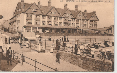
St. Hélier, Jersey, Channel Islands, ca early 1900s


These two sepia toned cards are souvenir picture postcards produced by one of the most important postcard editors in France during the golden age of postcards, Léon & Lévy or L.L.  L.L. was founded in 1864.  The initials L.L. were registered as a trademark in 1901.  The cards have divided backs, dating them to after 1902.  The card above has the number 223, and the title at the bottom left.  It shows the esplanade or wide walkway alongside the beach. 


Both cards offer a view into the past, showing people in typical dress of the time.  In this one there are horse drawn carriages seen between the hotel level and walkway, baby carriages, children, adults, and beach chairs. 


The second card, below, shows the front of the Grand Hotel and part of the long esplanade.  The number 50 and the title appear at the upper right corner.  A gated ramp leads down to the beach.  Men’s clothing has not changed much in over 100 years.  However, neither men nor women today would be wearing such long, warm clothing to a beach today. 


Grand Hotel, St. Hélier, Jersey, Channel Islands, ca early 1900s


St. Hélier is the capital and only city of Jersey, the largest of the Channel Islands in the English Channel.  The town is named after a 6th century hermit monk, Helerius, who converted the people on the island to Christianity and was later martyred by Saxon pirates in 555 A.D.  The Hermitage, is located in the bay and is accessible on foot at low tide.  Once a year, 16 July, there is an annual municipal and ecumenical pilgrimage to the island. 


For additional information, see:


https://en.wikipedia.org/wiki/Helier

https://en.wikipedia.org/wiki/L%C3%A9on_%26_L%C3%A9vy

https://en.wikipedia.org/wiki/St_Helier


Thursday, April 3, 2025

If this is Thursday it must be postcards, 705


Glasson Dock, Thurnham, Lancaster, England


This is an unused P. Frith & Co. Ltd. card featuring a photograph of Glasson Dock, located in Thurnham, Lancaster, England.  The title “Glasson Dock” and GNDK 42 are just off center at the bottom on the front of the card.  The photographer is not listed.


The small village of Glasson Dock, also known as Glasson, is located at the mouth of the River Lune in Lancashire, England.  Originally it was a community with farming and fishing as the main occupations.  As early as 1779 it was suggested that a dock or series of locks be built at Glasson to help ships navigate the River Lune to the port of Lancaster.  Difficulties, lack of funding, design problems, resulted in continuing delays.  Finally in 1823 work began.  The project involved building locks that would drop 52 ft or 16 m over 2.5 miles or 4 km.  Due to financial problems the warehouses and wharves could not be built first.  As a result, trade on the canal was slow.  


 By 1830 over 10,000 tons of goods passed through the dock.  The locks were 14 ft or 4.3 m wide, so smaller ships did not have to move cargoes to canal boats but could sail through.  The goods included slate, timber, potatoes, and grain.  Then in 1883 the dock was connected to the railway in Lancaster. Passenger services stopped in 1930 but goods continued until 1964.   


The trackbed is now a linear park and cycleway.  A limited amount of outgoing commercial traffic still uses the dock, including shipping coal to the Isle of Man and the Western Isles of Scotland.  Incoming shipments include animal foodstuffs and fertilizer that is stored in sheds located on the dock side.   


Because the River Lune has very little water during low tide, vessels can only enter during tidal windows.  Currently the broken sea gate is under repair and not expected to reopen until sometime in 2026.  In the meantime, a cofferdam will be installed this year (2025) and later removed when the repair work is completed on the gate.  This will help lessen the impact on sailing during the 2025-2026 season.  Glasson Dock is part of a hub connecting the Irish Sea, Morecambe Bay, the River Lune estuary, Glasson Marina, and the Lancaster Canal.


For additional information, see:


https://en.wikpedia.org/wiki/Glasson_Dock

https://www.bbc.com/news/articles/c9r3xx2npdpo

Thursday, March 6, 2025

If this is Thursday it must be postcards, 701


Diénay (Côte-d’Or) – Château Veil-Picard, France, 1922


This is an unused Vintage postcard with a divided back, greenish color on reverse, printed or published by Breger Freres [Breger Brothers] of Paris, France.  Edit. Michel and the title Diénay (Côte-d’Or) – Château Veil-Picard is printed on the front lower margin.  The name of the printer/publisher is found to the bottom right of the center line on the reverse.  The card was another one found in a shoe-box jumble, but also seen on eBay with the date of 1922.   


 Breger Freres Logo


The company logo is an interesting and different design.  Most logos for postcards use initials, geometric shapes or objects. 


Diénay, is a community located in the Côte-d’Or region in Northeastern France.  Formed from the former province of Burgundy, Côte-d’Or is one of the original 83 departments created during the French Revolution in 1790.  There are several other tourist attractions; however, the Château Veil-Picard is not listed among those named.  The picture on the card makes it look smaller than those that are listed.  Perhaps more like a villa or manor house than a château.  Since there are at least 100 châteaux or more in this area, it is possible that smaller ones do not get mentioned or often photographed.  This is a wine producing area where many of the châteaux have been converted into hotels or guest houses. 


Gallic Celts were the first recorded inhabitants of was became Burgundy.  They were incorporated into the Roman Empire.  A Germanic people, called Burgundians, and who may have originated on the island of Bornholm, settled in the western Alps during the 4th century.  The area changed hands a couple of times during conflicts between Germany and France.  The Abbey of Fontenay found in Burgundy, is a UNESCO World Heritage Site and has one of the best-preserved Cistercian abbeys in Burgundy.  Another UNESCO World Heritage Site, the Abbey of Vézelay is still a starting point for pilgrimages to Santiago de Compostela. 


Côte-d’Or is a department in the region of Bourgogne, or Burgundy in English.  From the early 11th to the late 15th century Burgundy was the home of the Dukes of Burgundy.  The capital was Dijon, like the mustard.  It was wealthy, powerful, and center for art and science.  The Duchy of Burgundy is said to have been key in the transition from the Middle Ages to early modern Europe.  This area was one of the largest ducal territories.  The area changed hands at different times during conflicts between Germany and France.  The Abbey of Fontenay found in Burgundy, is a UNESCO World Heritage Site and has one of the best-preserved Cistercian abbeys in Burgundy.  Another UNESCO World Heritage Site, the Abbey of Vézelay is still a starting point for pilgrimages to Santiago de Compostela. 


During the 100 Years’ War, King John II of France gave the duchy to his youngest son, Philip the Bold.  Later, King Louis XI of France took over the duchy itself.  The Low Countries, which had been part of Burgundy, passed to Duke Charles the Bold’s daughter, Mary, and her Habsburg descendants. 


For additional information, see:


https://en.wikipedia.org/wiki/Burgundy

https://en.wikipedia.org/wiki/Di%C3%A9nay

https://en.wikipedia.org/wiki/C%C3%B4te-d%27Or


Thursday, February 27, 2025

If this is Thursday it must be postcards, 700


 Tours, France, ca 1914-1924


The perforation on the left side of the card indicates that this card was one in a booklet set.  It is an unused Vintage souvenir postcard.  Featured are four black & white photo views of the city of Tours with a young woman or girl wearing a traditional headdress in the center.  At the bottom margin on the front of the card is the number 48, the title Tours, and A.P.  The has card has a divided back with the typical greenish color that can be found on many European vintage cards.  A. Thiriat & Cie of Toulouse is identified as the printer or publisher on the reverse center line.  The card was found in a shoebox jumble and was purchased at a local antique mall. 


Thiriat & Company of Toulouse was known to issue cards with pictures of places, also military scenes, and people in uniform.  The pictures with people in uniform suggest they were from the World War I era, 1914-1918.  It is not known if Thiriat published or just printed the cards. 


The city of Tours is located in the Centre-Val de Loire region of France.  Situated between Orleans and the Atlantic coast it was originally founded and named Caesarodunum [“hill of Caesar”] in the 1st century A.D. by the Roman Emperor Augustus.  During Gallic times it was an important point of crossing over the Loire River.  By the 4th century A.D. the name was Turones, later Civitas Turonum, and finally Tours.  The Tours Amphitheatre, one of the largest Roman amphitheaters, can be found there.  Tours folk lore says that Turonus, the nephew of Brutus, died and is buried in Tours and the city was founded around his grave. 


Tours is famous for its bridges crossing the Loire.  There are two pictures of bridges on the card, one at the upper left and the other at the lower right corners.  The photos appear to be of the Wilson Bridge taken from opposite sides of the river.  This bridge is named afater the U.S. President, Woodrow Wilson.  Also pictured on the card, at the upper right is the Hôtel de Ville, and at the lower left, the Tours Cathedral, Saint Gatianus. 


For additional information, see:


https://rthcards.co.uk/pclogos/data/THIRIAT/THIRIAT_01.html

https://en.wikipedia.org/wiki/H%C3%B4tel_de_Ville,_Tours

https://fr.wikipedia.org/wiki/Pont_Wilson_(Tours)

https://en.wikipedia.org/wiki/Tours


Thursday, January 23, 2025

If this is Thursday it must be postcards, 695


Lombadas Mineral Water Building, St. Miguel, Azores, ca early 1900s


This is an unused Vintage postcard with a divided back dating from the early 1900s.  The number 7 appears at the lower left on the reverse.  Along the left border, also on the back side of the card, is:  Café Tavares, Largo  Conselheiro João Franco.  No photographer is identified.  The place shown on the card is the mineral water building in St. Miguel (Michael), Azores.  I found the card in a shoebox jumble at the local antique mall.  


Although it is no longer being used, mineral water was bottled here.  Because the soil is volcanic and heavily enriched with carbon dioxide, the spring produces a natural sparkling water.  The water is also rich in minerals, especially iron.  Red iron residue can be found in the nearby stream beds.  The buildings in the photograph have been abandoned and are now covered in moss and other vegetation due to the warm humid climate.


São Miguel Island (Saint Michael) is called the Green Island.  It is the largest and most populous island in the Azores.  The island has six volcanic zones.  Most of the people live along the coasts due to volcanic cones and craters in the interior. 


For additional information, see:


https://en.wikipedia.org/wiki/S%C3%A3o_Miguel_Island

https://www.discover-azores.com/en/lost-places-nature-always-wins/


Thursday, December 12, 2024

If this is Thursday it must be postcards, 689


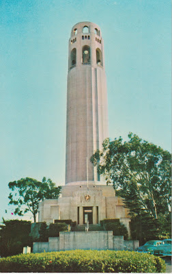
Coit Tower, San Francisco, California


Featured on this unused Selithco [Security Lithograph Co.] True Color, from Ektachrome, postcard is a photograph of Coit Memorial Tower, San Francisco, California.  The card was published by E F. Clements of San Francisco.  The number 1652 and a blurb appear at the upper left corner on the reverse.  The blurb:  “Coit Memorial Tower, Pioneer Park, San Francisco, is on the summit of Telegraph Hill.  The glass enclosed observation gallery atop the slim fluted-concrete column, is 540 feet above the water of the Bay, affording a view of the entire Bay Area.”


Also known as Coit Tower, it was built between 1932 and 1933 using a bequest from Lillie Hitchcock Coit to beautify the city of San Francisco.  In 2008 it was added to the National Register of Historic Places.  The tower is constructed of unpainted reinforced concrete and designed by architects Arthur Brown, Jr., and Henry Temple Howard.  It has an Art Deco style that was popular during the 1930s.  Fresco murals in the American Social Realism style were painted by 22 different onsite artists and assistants.  Other artworks were completed on canvas offsite. 


The views from the tower of San Francisco from Telegraph Hill are spectacular.  There were two bequests from the Coit estate.  One was to honor volunteer firemen, the other to beautify the city.  Some have confused the two and erroneously claimed that the design of Coit tower resembles a fire hose nozzle.  However, the monument to the firemen is in the form of statuary located in Washington Square and is not connected with the tower.  Above the main entrance to the tower there is a concrete relief of a phoenix by sculptor Robert Boardman Howard.  The relief was commissioned by the architect and cast as part of Coit Tower. 


For additional information, see:


https://en.wikipedia.org/wiki/Coit_Tower


Thursday, November 14, 2024

If this is Thursday it must be postcards, 685


Chapel by the Lake, Auke Bay, Alaska, ca 1960

[photo by Howard C. Robinson]


The unused postcard shared this week features a photo by Howard C. Robinson of the Chapel by the Lake.  At the bottom left on the reverse there is C8716 and credit to Robinson.  At the upper left on the reverse is a short blurb:  “World famous Chapel by the Lake, Auke Bay, Alaska, with Mendenhall Glacier in the background.”  The card was published by C.P. Johnston Company of Seattle, Washington using color by Mike Roberts.  This card was one of several found in a jumble box at a local antique mall. 


Architects Howard Foss and Linn A. Forrest designed this Presbyterian church located in Auke Bay, Alaska.  Construction began in 1954 and was completed in 1958.  There is no date or postmark on the card but the date of the card can be estimated based on the new-like appearance of the interior shown on the card.  The style is an example of Rustic architecture.  There are large windows behind the altar that look out across Auke Lake to the famous Mendenhall Glacier.  The scenic, suburban location makes this chapel a popular venue for weddings. 


Auke Lake is found in Auke Bay, Juneau, Alaska.  In addition to Dolly Varden, cutthroat, and steelhead there are four other varieties of salmon live in the lake.  The views from the Glacier Hwy side of Auke Lake are often photographed. 


Mendenhall Glacier has been significantly receding.  When my parents visited in the early 1960s the glacier was close to the visitor center and the lake was much smaller with almost no beach.  When Bob and I were there in 2019, Mendenhall Lake had increased and the visitor center was at the beginning of a trail down to the large lake beach.


 Mendenhall Glacier, 2019


As can be seen in these photos from 2019, Mendenhall Lake has grown in size between the edge of the glacier and the pathway down from the visitor center.  The glacier is still massive but is continuing to shrink. 


Mendenhall Glacier and beach with people standing by the lake, 2019 


Mendenhall Glacier is about 13.6 miles or 21.9 km long and is located about 12 miles or 19 km from downtown Juneau.  The glacier and the surrounding areas are protected as the Mendenhall Glacier Recreation Area within the Tongass National Forest.  Since 1942 the Juneau Icefield Research Program has monitored the outlet glaciers.  Since 1929 when the lake was created, the glacier has receded 1.75 miles or 2.82 km.  It has receded a total of 2.5 miles or 4 km since 1500.  A statement from the U.S. Forest Service, which manages the Mendenhall Glacier, says: “because glaciers are a product of climate, they respond to climate change.”  The glacier is expected to continue receding in the foreseeable future due to a generally warming climate in Southeast Alaska. 


Nugget falls, the beach, lake, and Mendenhall Glacier, 2019 


Nugget Falls


Mendenhall Glacier Visitor Center, 2019


https://en.wikipedia.org/wiki/Chapel_by_the_Lake

https://en.wikipedia.org/wiki/Mendenhall_Glacier

https://en.wikipedia.org/wiki/Auke_Bay,_Juneau

https://en.wikipedia.org/wiki/Auke_Lake


Thursday, October 17, 2024

If this is Thursday it must be postcards, 681


Malmesbury, Wiltshire, England, ca 1902-1905


The used divided back postcard shared this week, is a souvenir type card with six views of landmarks in the town of Malmesbury, Wiltshire, England.  At the left margin on the reverse the card it is identified as “The ‘Famous’ series, Tomkins & Barrett, Swindon.On the front of the card each landmark is separately identified at the bottom of the picture.  The top row, from the left:  exterior view of the Abbey, Market Cross, and an interior view of the Abbey.  Bottom row, from the left:  Cowbridge House, Charlton Church, and High Street.  If one looks carefully, a very faint X can be on the High Street photo at the lower right.  At the upper right corner is a place for a Halfpenny stamp.  Halfpenny stamps were used between 1870 and 1906, suggesting that this card dates from 1902 when divided backs were introduced in England to 1906.


Multi-view cards as souvenirs have been printed as early as the 1880s and are still popular today.  This card is addressed to Mr. & Mrs. Jacques Matenge and has a handwritten note on the back of the card that reads:  “Ingram House, Malmesbury.  The Mayor and Mayoress (Mr. & Mrs. Adyed) wish you the compliments of the season & hope you are all quite well & happy.  You will recognize the views, our house marked X.  Best wishes.” 


Malmesbury is a town and civil parish in north Wiltshire, England.  The older part of the town is on a hilltop that had once been the site of an Iron Age fort.  There are several freshwater springs on the hilltop that helped the early settlers.  The Abbey was originally founded in 675 by an Irishman named Maildubh.  The town takes its name from a combination of Maildubh and burh or Maildubh’s fortification which later morphed into Malmesbury.  During medieval times the Abbey became well known as a place of learning. 


Some trivia facts of interest, in 1010 there was an early attempt at human flight when a monk, Eilmer of Malmesbury, flew a primitive hang glider from the tower.  He flew over 180 meters or about 590 feet before (crash) landing and breaking both of his legs.  By 1066 when a census, called the Domesday Book, was taken Malmesbury is listed as the first, or most important town, in Wiltshire.  The wooden town walls were replaced by stone walls during the 1100s. 


Today Malmesbury is best known for its abbey.  The economy is mostly agriculturally based but also depends on tourism. 


For additional information, see:


https://en.wikipedia.org/wiki/Malmesbury

https://en.wikipedia.org/wiki/Malmesbury_Abbey

https://worldpostcardday.com/history


Thursday, September 19, 2024

If this is Thursday it must be postcards, 677


Tower Fall, Yellowstone National Park


This unused postcard features a photograph of Tower Fall by Steve Hinch and is a Yellowstone Forever product.  The number 45 appears on the center line on the reverse.  At the upper left is a blurb:  “Yellowstone National Park  The mist from the waters of 132 foot Tower Fall gives birth to a rainbow.  A member of the Washburn Party of 1870 described the fall in his diary:  ‘Campt near the most beautiful falls—I ever saw—I named them ‘Tower falls’ from the towers and pinnacles that surround them’.” 


When we visited Yellowstone National Park earlier this summer we were in the western part of the park and did not see these falls which are located in the northeastern section.  However, the card shows some of the beauty and wild nature of the region. 


There were two expeditions to Yellowstone prior to its being designated as a national park.  The first was the Cook-Folsom-Peterson Expedition that took place in September 1869.  This was a privately financed expedition carried out by David E. Folsom, Charles W. Cook, and William Peterson of Diamond City, Montana.  They spent one day, 15 September, in the Tower Fall area before crossing the river and traveling up the Lamar River, an eastern tributary fork of the Yellowstone River the next day. The second expedition was almost a year later, in August of 1870, led by Henry D. Washburn and Nathaniel P. Langford, with a U.S. Army escort headed by Lt. Gustavus C. Doane for a total of 18 members in the group.  They followed the general route that Cook-Folsom-Peterson had taken the year before.  Both groups kept journals and made maps during the expeditions. 


Following the first expedition, Folsom went to work for Washburn as a surveyor.  One of the members of the second group was Judge Cornelius Hedges who was a Montana writer and lawyer who wrote articles for a Helena, Montana newspaper describing where they went and what they saw.  Hedges was a vocal supporter of preserving the Yellowstone region as a National Park. 


For more information, including photos and a journal excerpt, see:


https://en.wikipedia.org/wiki/Tower_Fall

https://www.nps.gov/articles/000/lamar-river.htm

https://en.wikipedia.org/wiki/Lamar_River

https://en.wikipedia.org/wiki/Cook%E2%80%93Folsom%E2%80%93Peterson_Expedition

https://en.wikipedia.org/wiki/Washburn%E2%80%93Langford%E2%80%93Doane_Expedition


Friday, September 13, 2024

Palouse to Cascade Trail, Hyak, Snoqualmie Pass, 2024


Palouse to Cascade Trail, Hyak, Snoqualmie


The trail, now called the Palouse to Cascade, was previously called the John Wayne Trail.  Located just east of the Snoqualmie Summit, it is in the Iron Horse State Park and requires a Discover Pass or a day use fee.  The picture shows the almost empty parking lot.  We cross-country ski here often in the winter when the lot is nearly or completely full of cars.  In addition to the groomed cross-country trail there is a sledding hill and snow shoe trails.  The orange building is a replica of an old railroad depot and is a public restroom that is open all year.  It has unheard of luxuries like heat in the winter, flush toilets and sinks with running water and hot air blowers.  Two of the six unisex units also have showers. 


Part of the trail is used as a short cut between Tacoma Pass and Snoqualmie Pass for Pacific Crest Trail (PCT) thru hikers, some having spent the previous night at Tacoma Pass.  We had a nice visit with a couple from Switzerland.  Most thru hikers try to go 20 miles or more each day putting their goal of the Canadian-US border about 10 days to 2 weeks from the day we met them. 


 Most of the trail looks like this


with views of Lake Keechelus here and there.


Since it is an old railroad, it is mostly flat with gentle curves and very gradual or minimal elevation changes.  There are views of Lake Keechelus, mixed forest, and little streams feeding into the lake below.  This week Bob timed our hike to extend our distance a bit to approximately 5.3 miles RT. 


There are informational placards in a couple of places along the route.  This one featured information about the electric trains.  The original line was called the Chicago, Milwaukee, St. Paul, and Pacific, known as the Milwaukee Road.  The passenger train was named the Olympian-Hiawatha.  This particular passenger train was one of the fastest and most luxurious transcontinental trains during the era of the Milwaukee Road, 1905-1974. 


 A little fall color, mostly on vine maples, a few late flowers, lots of brilliant blue sky with clouds, cool breeze, sunshine and comfortable temperature.  


A little fall color, vine maple


Daisies


Mullein


Spotted Knapweed


Butter & Eggs, Toadflax


Spotted Tussock Moth caterpillar sometimes called "woolly bear"


Count for the day:

30 people total, 18 mountain bikers, a few were on electric bikes, 7 were thru hikers, and 5 day hikers

No dogs

Our timed hike = 5.3 miles RT 


Thursday, September 12, 2024

If this is Thursday it must be poscards, 676


Yellowstone National Park, illustration by Heinrich Berann


Featured on this Yellowstone Forever unused postcard above is an aerial view illustration by Heinrich Berann.  The number 43 appears on the center line on the reverse.  There is also a blurb on the reverse at the upper left corner:  “Yellowstone—the world’s first national park—encompasses an area of over 2.2 million acres and is larger than Rhode Island and Delaware combined.  The park’s landscape is also diverse, from the forest and rolling hillsides surrounding Reese Creek at the park’s lowest point at 5,282 feet to the mountainous terrain of its highest point of 11,358 at Eagle Peak.” 


Yellowstone National Park is such a fascinating and amazing place.  The overview view on the card helps to show how vast and varied the area the park encompasses.  There are animals such as bison, deer, elk, moose, antelope, bears, wolves, coyotes, cougars, fish, reptiles, amphibians and many different kinds of birds. The landscape is almost surreal with mountains, geysers, boiling mud pots, rivers, meadows with hundreds of flowers, and forests.  


 This second unused postcard is also a Yellowstone Forever product.  It has a collection of 10 acid free stickers and are "perfect for Scrapbooking" according to the blurb at the upper left on the reverse.  From the left top row:  Canary Spring, American Bison, Emerald Pool, Black Sand Basin.  Middle row:  Wolf, Grand Prismatic Spring, American Grizzly Bear.  Bottom row:  Castle Geyser, Cow Elk with Calf, and Lower Falls of the Yellowstone (river).  The stickers were produced by Pigment & Hue, Inc.


 It is not possible to see everything in the park on one trip there.  On a previous visit we saw entirely different parts of this huge park.  This time we had opportunities to make multiple trips into the park during our 10-day stay as part of an extended family gathering.  Bob and I probably had more ventures into the park than most of the rest of the group since we were interested in the park itself rather than shopping or exploring neighboring areas.  Although, as previously noted, we also went with the group to visit Bear World, and spent part of one day in the town of West Yellowstone visiting the Bear & Wolf Museum as well as getting a few postcards and souvenirs. 


As expected, there were many people and lots of cars in the park.  Huge crowds waited for Old Faithful to erupt.  Boardwalks around geyser basins were crowded too.  We were stopped more than once by “bison (or buffalo) jams” as the animals lumbered across the roadway seemingly uncaring of cars or gawking people with cameras.  Once three bison mamas, each with a calf, started across right in front of our car.  One of the babies decided to dance around unpredictably in the roadway, darting in and out of road and the forest alongside the road.  We did not dare to drive forward until it crossed over to join its friends and then the mother ambled slowly after once the dance was done. 


Some days there were long lines of cars at the entry gate.  Thankfully there is a separate gate for people with National Park passes, so we could get through quickly and did not have to pay an additional fee.  On the day we carpooled as a group to the park, each car had at least one person with a pass making it much easier and less expensive than it could have been otherwise. 


The park spans the northwest corner of Wyoming and extends into Montana and Idaho.  The 42nd U.S. Congress established the Yellowstone National Park Protection Act which was signed into law by President Ulysses S. Grant in 1872.  The park became a UNESCO World Heritage Site in 1978.  “It is the largest remaining nearly intact ecosystem in the Earth’s northern temperate zone.”  It is believed that Native Americans lived in the Yellowstone region for more than 11,000 years. 


For more information, see:


https://en.wikipedia.org/wiki/Yellowstone_National_Park

www.pigmentandhue.com