Showing posts with label Seattle. Show all posts

Thursday, August 19, 2021

If this is Thursday it must be postcards, 517


Ballard Locks, painting by Carl Funseth


This Carl Funseth painting of the Ballard Locks is found on an unused postcard published by Mark Ukelson.  The reprints of the original painting are available through Russell Galleries in Seattle.  The card was purchased at the Locks gift shop. 


The artist, Carl Edward Funseth (1931-2000) was well known for his paintings, many local scenes in Spokane.  His work is described as straddling impressionism and naturalism.  His series of old Seattle, such as on the postcard, were made into prints. 


The Ballard Locks or Hiram M. Chittenden Locks are located at the west end of Salmon Bay, in Seattle, Washington’s Lake Washington Ship Canal between Ballard and Magnolia.  These locks have more boat traffic than any other lock in the United States.  There are also a fish ladder and botantical gardens on the grounds surrounding the locks.  When we visited here recently we saw large boats in the larger lock and small pleasure craft, including several kayaks, in the smaller lock.  An added attraction that day were the harbor seals hunting for fish in and around the locks and a great blue heron that was also fishing. 


A navigable connection between the fresh water in Lake Washington, 8.8 ft or 2.7 m higher than the salt water Puget Sound, for the purpose of moving logs, milled lumber and fishing vessels was a topic of discussion as early as 1854.  Originally a Naval shipyard was also proposed but later that was built at Bremerton instead.  In 1867 the United States Navy endorsed the canal project but it was not until 1891 that the U.S. Army Corps of Engineers started planning the project.  Some work began in 1906 but work in earnest did not begin until 1911 under the direction of Hiram M. Chittenden for whom the locks are named.  The locks were completed in 1916/1917 .  The Lees visited the locks shortly after they were open to the public and would often bring out of town visitors to see the locks.  There are movable walkways that allow visitors to watch as the water is raised and lowered and the boats pass through to either the Sound or the Lake.


The construction of the Locks required rerouting the Cedar River into Lake Washington so that there would be sufficient water flow for operating the locks.  The rerouting disrupted the Duwamish salmon runs.  To solve that problem salmon runs were reintroduced to migrate through the locks via fish ladders.  To prevent salt water from flowing upstream into the fresh water lakes it was necessary to design of system of siphons and flushing mechanisms.  Also, the Cedar River is the main source of drinking water for the city of Seattle so problems with maintaining an adequate water supply to operate the locks needed solving.  The second unused postcard, also purchased at the Locks gift shop, has views of the lock construction as well as drawings of how the locks work. 


An Impact photo graphics card with Impact photography


For additional information, see:


https://en.wikipedia.org/wiki/Ballard_Locks

https://www.legacy.com/us/obituaries/spokesman/name/carl-funseth


Thursday, September 26, 2019

If this is Thursday it must be postcards, 418


The Kalakala Ferry


This unused Lantern Press Vintage Art postcard with an artist rendition of the ferry Kalakala is numbered 6548.  It was interesting to find out that the ferry was first constructed for the Key System’s ferry service on San Francisco Bay between Oakland and San Francisco.  Key System was a private company that in addition to the ferry line also operated streetcars, bus lines, and trains.  At the time the ferry was part of Key System it was named Peralta after one of the early Spanish founding families in California.  The Peralta, powered by a steam-turbo-electric system, was launched in 1926.  Unfortunately, while the ferry was moored at Oakland in 1933 an arson fire started in an adjacent train shed and spread to the Peralta resulting in the superstructure collapsing due to the intense heat.  The ferry was written off by the insurance company but still had an intact hull.

In October 1933 the Peralta hull was sold to the Puget Sound Navigation Company, also known as the Black Ball Line, and towed by tug boat to the Lake Washington Shipyards in Houghton (now part of Kirkland) to be restored and used as a ferry.  It took 2 years to rebuild.  A single engine diesel engine was installed, and the length of the ferry was reduced from 68 feet to 55 feet 8 inches.  A new electro-welding process was used instead of rivet construction giving the ferry a streamlined seamless appearance.  The new bridge and wheelhouse were built of copper.  In 1934 the ferry was re-named Kalakala, said to mean “bird” in Pacific Northwest Native American Chinook Jargon.  The naming of this ferry started the tradition of all vessels in the ferry fleet of the Washington State Department of Transportation having indigenous names.

Service between Seattle and Bremerton on the Kalakala began 4 July 1935.  The design of the ferry was instantly popular and the ferry was often photographed.  Moonlight cruises on the Kalakala with a live dance orchestra were offered in addition to the regular ferry service.  During World War II service on the Kalakala was extended to allow for transportation of Navy personnel and shipyard workers from Seattle to Bremerton.  At that time the ferry gained the title “The Workhorse of Puget Sound.”

The art deco or quirky, space age design had some disadvantages.  Because the wheelhouse was set back it was impossible to see the bow of the vessel which lead to difficulties when docking.  The small size of the wheelhouse and round windows also made visibility problems.  The car deck was not wide enough to comfortably accommodate postwar vehicles that were wider than earlier cars resulting in a drop of about 40% in the number of cars that could be carried.  By the mid 1950s the Kalakala had become obsolete for runs across the Sound.  The enclosed design made her suitable for open water routes and she was transferred to the Port Angeles to Victoria, B.C. run where she served from 1955 to 1959.  The Kalakala was also used for tours of the Bremerton Shipyards during the Seattle World’s Fair, 1962. 

We rode on the Kalakala several times.  The engine vibration and heavy shaking that ran throughout the vessel when in operation was very noticeable and part of the experience.  The ferry had several nicknames, The Silver Swan, The Silver Slug, Silver Beetle, Galloping Ghost of the Pacific Coast, and by Seattle’s Scandinavians as Kackerlacka (cockroach).

In 1967 the Kalakala retired from service altogether, was moved to a repair facility at Eagle Harbour and sold a year later to a seafood processing company.  After the sale the ferry was towed to Alaska to work as a crab cannery at Ouzinkie, Alaska. In 1970 the Kalakala was beached at Kodiak and used to process shrimp.  From 1984 to 2011 several attempts were made by various people to save the ferry but finally the Coast Guard declared it a hazard to navigation and it was scrapped in 2015.  Only a few pieces were sold as souvenirs.  Some of the scrapped pieces were purchased by the city of Kirkland with an idea of using them in a public art project.

For additional information, see:

https://en.wikipedia.org/wiki/Key_System
https://en.wikipedia.org/wiki/MV_Kalakala

Saturday, December 30, 2017

If this is Thursday it must be postcards, 331 [a few days late]


 Snowy trees in front of the Harry Whitney Treat Home, Queen Anne and Highland Drive, Seattle, 
ca 1916


 [Note:  I was without a computer for a few days so this Thursday postcard is a few days overdue.]

Although this postcard looks more like a snapshot than a card it was printed as a postcard.  That was a fairly common way to share pictures of places, people and even pets in the early 1900s.  There has not yet been significant snow in the city this year but the photo was probably taken in 1916 when Seattle had a heavy snowfall.  The undated note on the back says:  “In front of Harry Whitney Treat’s Home, Queen Anne and Highland Drive.”  The Treat family lived in this 64-room home from the time it was completed in 1905 until his death in 1922 when it was sold to developers.  Then it was turned into apartments.  In 1975 it was modified into what is today known as the Gable House complex.  It is a Seattle Landmark building worth more than 11 million dollars.

I thought it interesting and amusing to think that someone took this picture showing the snow covered trees and not much of the mansion.

Harry Whitney Treat was a businessman and financier who originally came from New York and arrived in Seattle in 1902.  He formed a partnership in 1896 with the promoter, Ed Blewett, for whom Blewett Pass is named.  Together they formed the Van Anda Copper and Gold Company on Texada Island in the San Juan Islands.  They had three mines, the Little Billie, the Copper Queen, and later the Cornell.  Under Treat’s leadership the mining operations moved underground.  Blewett and Treat developed a narrow gauge railway to move the ore to dumps on Van Anda Bay.  By 1900 they had also constructed a smelter to service not only their mines but also other mines on the island.  Treat was called “The Magician” who waved an invisible wand and his caves produced copper, gold and silver. 

Locally Treat bought hundreds of acres of land in Ballard where he developed Loyal Heights and Loyal Beach, both named for his youngest daughter, Loyal Graef Treat.  Loyal Beach later became Golden Gardens Park.

For more information, see:

https://seattle.curbed.com/2014/9/3/10051856/treat-house-gable
Texada Island Heritage Society – Harry Whitney Treat
https://en.wikipedia.org/wiki/Texada_Island

Monday, February 15, 2016

Mrs. Piper's forgotten garden


Snowdrops

Carkeek Park has a trail system through the woods in addition to the more familiar beach access.  Following the Great Seattle Fire of 1889 that destroyed his bakery, Andrew Piper and his wife, Minna, moved to what is now Carkeek Park and settled on land that had abandoned cabins on it from earlier logging.  They planted an orchard, vegetable and flower gardens.  After the Pipers passed away their heirs sold the land to the Carkeek family who later donated it to the city in 1927 for a park. 

My aunt and uncle once had a home near Carkeek Park.  Bob and I mentioned that we had taken walks in the park and my uncle asked us to see if his water wheel was still on the property the next time we did that.  He also wondered if we had walked down to the orchard.  The next time we went on a walk in the park we stopped by where their house used to be but is no longer standing.  However, the water wheel is still there. This time we approached the orchard from the bottom instead of walking down the hill from the house as I remember doing with my brother and cousins when we were kids. 


A section of the old orchard

The orchard was left fallow until 1983 when it was accidentally rediscovered by a group of orchard enthusiasts who noted orderly rows of fruit trees among the alders, maples, blackberry vines and other undergrowth.  Volunteers associated with the Western Cascades Fruit Society cleared the area and eventually planted other trees so that today there are early varieties of apple, walnut, filbert, chestnut, quince, pear, cherry, hawthorn, hickory, and elderberry growing on the hillside.  These volunteers continue to maintain the orchard.  Most of the trees bear fruit that is no longer produced commercially. Some of the very old trees dating from around 1900 have partially fallen over but still produce fruit.  Cider made from the apples is used at Adopt-A-Park and other city sponsored events.  There is a placard at the foot of the orchard hill with photographs and a diagram showing the location of the trees.  Most of the fruit trees have metal tags identifying them.


Informational placard

It is an easy walk up to the orchard from the parking lot.  A short distance off the path and hidden along the stream that runs alongside the orchard there are still flowers that Mrs. Piper planted.  If one goes in mid February it is possible to come across thousands of snowdrops.  To find Mrs. Piper’s forgotten garden and see so many of these delicate lovely flowers in such profusion is a delight.


 Snowdrops now growing wild


Thursday, October 29, 2015

If this is Thursday it must be postcards, 218


Foundation piles for the Smith Tower, ca 1910

This is a rather amazing look into the construction of the Smith Tower in Seattle Washington.  Plans for the construction of the tower were considered as early as 1909 with commencement of the project in 1910.  The tower was completed in 1914, a 42 story building the tallest west of the Mississippi at the time.  It continued to be the tallest building on the West Coast until the Space Needle was built in 1962.  The postcard photo shows the 1281 friction piles that support the tower and notes that the L.C. Smith Building weighs approximately 49,000 tons.  To provide some idea of immensity of the project, notice the small blue dots in the picture, these are the workmen. 

No publisher or photographer is given on the front or reverse of this card or on the one below that shows the completed tower.  Since both cards do have the same design on the reverse; however, most likely they were published about the same time by the same company dating them to 1914 or shortly thereafter.  The original photos would have been black & white, then tinted before mass producing as postcards.


L.C. Smith Tower, ca 1914-1920


Reverse

The next postcard below shows the tower after dark.  Frank H. Nowell, who took many of the pictures for the Alaska Yukon Pacific Exposition in 1909, is identified as the photographer and the Loman & Hanford Co., of Seattle, published the card.  Loman & Hanford was a stationery and printing company (1894-1955), later bought out by the Portland, Oregon company, J.K. Gill (1868 – 1999).  Neither of these companies exist today.


Smith Tower after dark

The Smith Tower was funded by and named after the American industrialist Lyman Cornelius Smith (1850-1910) who died before the building was completed.  His son, Burns Lyman Smith, had convinced him to build the 42-story structure instead of the 14-story building he had first envisioned.  During the course of his life Smith was involved in several business ventures, livestock, lumber, firearms (L.C. Smith Shotgun) and eventually typewriters (Smith-Corona).  The firearms and typewriters proved to be the most successful.  The shotguns were produced from the 1880s to about 1950 with a brief revival in 1967, then retired in 1972.  Computers caused a decline in typewriter sales beginning in the 1980s. 

For more information about Smith Tower and L.C. Smith, see: 

https://en.wikipedia.org/wiki/Smith_Tower
https://en.wikipedia.org/wiki/Lyman_Cornelius_Smith

Thursday, September 3, 2015

If this is Thursday it must be postcards, 210


 President Rutherford B. Hayes addressing the citizens of Seattle, 1880

The postcard this week is a vintage card and one that is in the historical postcard category.  It is unused, sepia toned and printed in 1911 although the photograph was taken in 1880 by Otto Theodore Frasch a Seattle photographer who signed his postcard photos O.T. Frasch as can be seen at the lower right corner with the number 859.   The event pictured is the first presidential visit to Seattle by a United States President in office at the time of the visit.  In the explanation of the event at the bottom left and center of the card the date is given as 1881 but according to historical records President Rutherford B. Hayes took his tour west of the Rocky Mountains in 1880 not 1881.  [Historylink.org provides the exact date as 11 October 1880.]

The Occidental Hotel shown in the photograph was built in 1861 between Mill Street and James Street and torn down in 1883 to make room for a newer, grander hotel by the same name built at the same location.  The second Occidental Hotel burned down during the Great Seattle Fire of 1889.  In 1890 a third Occidental Hotel was built on the ashes of the second hotel and was known as the Seattle Hotel.  It was triangular-shaped and had the inscription 1890 above the fifth story window to signify the year it was completed.  This third hotel was torn down and replaced with a parking garage, sometimes called the “Sinking Ship,” in 1961. 

The crowd in the photograph is large; however, the total population of Seattle in 1880 was 3,533 and it does not look like quite that many people are gathered at the Occidental Hotel to hear him speak.   One account said that at a reception that evening held in the President’s honor at Squire’s Opera House, he shook hands with 2,000 people.  It was said that it was the most exciting night in Seattle’s history with stores, houses, and the university all ablaze with candles, lamps, and gas.  Bonfires were lit in Occidental Square and a band played while people milled in the streets.

President Hayes was the 19th United States President serving from 1877 to 1881.  His “Great Western Tour” involved travel by train, horse and boat as he crossed the country from his native Ohio to California with stops in Oregon and Washington Territory.  Accompanying the president was his wife, Lucy, Civil War General William T. Sherman, and Secretary of War Alexander Ramsey.  It took them two weeks by horse drawn coach to travel from San Francisco to Ashland, Oregon.  The party traveled to Portland, to Forest Grove, Oregon, to Walla Walla, Washington, crossing the Columbia River by steamboat, from there to Tenino, by narrow gauge rail to Tumwater and Olympia and finally by the steamer “George E. Starr” to Seattle, and then on to Port Gamble, Port Blakely and Port Townsend.  He gave speeches at his stops but some were short.  On the return trip he stopped at Tacoma and Astoria before returning to Ohio in time for the 1880 election.  The 1876 election had been contentious with Hayes winning the Electoral College vote but not the popular vote and as part of a compromise Hayes had agreed not to seek a second term.  Instead he supported James A. Garfield who won in 1880.

President Hayes was born in 1822 and died in 1893.  “As president he oversaw the end of Reconstruction, began the efforts that led to civil service reform, and attempted to reconcile the divisions left over from the Civil War and Reconstruction.”  [Wikipedia]  He succeeded Ulysses Grant. 

  For additional information, see:

https://en.wikipedia.org/wiki/Rutherford_B._Hayes
http://otfrasch.com/
http://mynorthwest.com/?sid=2369138&nid=651
http://www.historylink.org/index.cfm?DisplayPage=output.cfm&file_id=882
Paul Dorpat (19 September 2014) “See Seattle’s grand Occidental Hotel in 1887” (h
ttp://seattletimes.com/html/pacificnw/202445087_092lnowandtenxml.html).  Seattletimes.com

Thursday, July 9, 2015

If this is Thursday it must be postcards, 202


Broadway High School, ca 1904

When it opened in 1902 Broadway High School on Capitol Hill was the first dedicated high school in Seattle and was called simply the Seattle High School.  Seven years later the name was changed to Broadway High School after the street that runs in front of the building and a second high school, Lincoln, had opened in the Wallingford neighborhood.   It was no longer used as a high school after 1946 but became instead of technical/vocational school for adults and still later in 1966 Seattle Community College purchased it for the central campus.  Today most of the original building is no longer standing, only the auditorium, Broadway Performance Hall, is used as a venue for arts and lectures and some large stones were also salvaged from the front entrance. 

The postcard above shows the building as it was sometime between 1902 and 1907 when it was still called The Seattle High School and when postcards had undivided backs.  The publisher is identified as The Puget Sound News Company, Seattle, Washington with the printer as A N C Excelsior of New York, Leipzig, Dresden, and Berlin, Germany.  The company logo is a three-leaf clover with an omega shaped border (see below).


Logo of A N C Excelsior

The architects for Broadway High School were William Boone (1830-1921) and James M. Corner.  Boone was a prominent pre-fire Seattle architect who had worked previously with George Meeker, William H. Willcox and finally J. M. Corner.  Many of the buildings he designed were destroyed during the fire.   Some of Seattle’s earliest brick buildings were designed by him some still standing in the Pioneer Square district others were destroyed during the Great Fire of 1889. 

Finding the card in a Pike Place Market shop was a delight since my father and his sister both attended and graduated from Broadway High School.  This yearbook picture of them as seniors in 1931, below found on Ancestry.com, added to the family history also.   It was touching and informative to see what was said about both Dad and Betty.   He always had an infectious ready laugh, was indeed generous and very good-natured, and liked and respected by many all of his life.   Mom used to tell us that Dad held the record for running the stairs at Broadway High that was unequaled for several years.  Both Dad and Betty enjoyed music, he played the violin in the school orchestra (one of his great-grandsons plays violin today) and had a good singing voice.  Betty was a year younger and had skipped a grade so they graduated the same year.  She played the piano and sang also.


Broadway High School Yearbook "Sealth" 1931
[source:  Ancestry.com]

For additional information, see:

http://www.historylink.org/index.cfm?DisplayPage=output.cfm&file_id=3204
https://en.wikipedia.org/wiki/William_E._Boone

Monday, April 13, 2015

Schmitz Park


Errands kept us in the city hence a city park to explore for an hour or two on a nice day.  This time we visited Schmitz Preserve Park in West Seattle another hike written up in Footloose in Seattle by Janice Krenmayr.   The park is located about 15 blocks east of Alki Point in West Seattle and contains the only remaining old growth forest in the city.  In 1908 Ferdinand and Emma Schmitz donated 30 acres of land to the city for a park.  Additional land was purchased in 1909, 1930, 1947 and 1958.  

Just to remind us that we were still in the city here is what we saw along the stairway down to the park trail from the street level.  The underside of the bridge was the only place we did see graffiti in the park; however, and it looked as if the upper part of the bridge was kept clean of it.


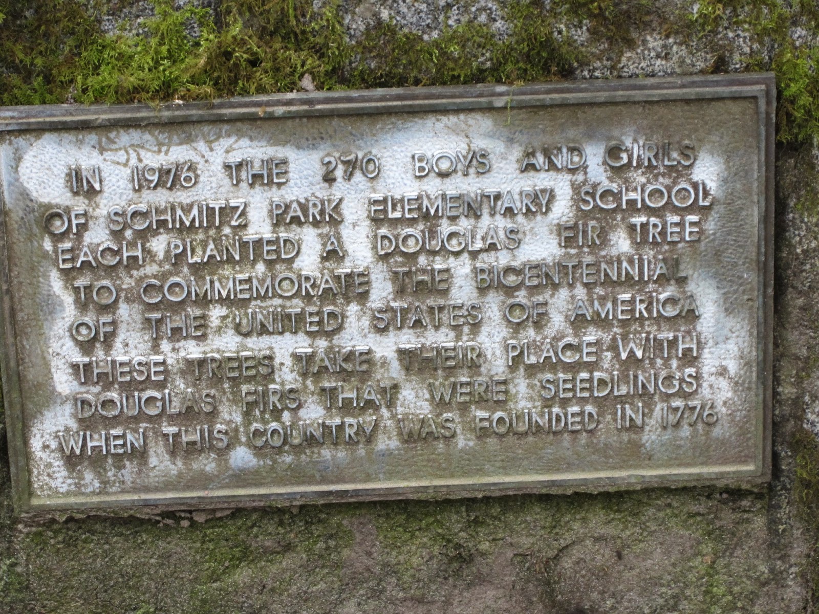
The single story Schmitz Park Elementary School adjacent to the park was opened in 1953.  This plaque pictured below in the park tells of tree plantings done by the school children for the 1976 bicentennial of the United States.


We took the loop trail but there are also several trails branching off here and there with plenty of places to roam in this nature preserve.  The trail surface is packed dirt with a cover of leaves and needles.  A creek runs through the park and there are small rivulets here and there making occasional muddy spots but also providing a nice running water sound.  Once inside a little way the traffic noise disappears and is replaced by bird song, breezes in the trees and gurgling water. 


One tree had formed this low arch that was still high enough to crawl under.

We saw Bleeding Hearts, Fringe Cups, Trillium, Salmon Berry, Elder Berry, Trailing Blackberry, Miner’s Lettuce, Aven, Skunk Cabbage and ferns in addition to big trees in this mixed forest. 


Bleeding Heart


 Fringe Cup


The Trillium flower starts out white and turns purple as it ages


Salmon Berry


Trailing Blackberry


 Skunk Cabbage

A few areas were fenced off while work was being done to encourage growth of selected native plants and trees.  One downed tree sported artwork to make it look like a toothy critter.


The loop took us to the other side of the bridge and a short walk back on the street level to the car. 


 New wall and park marker


Old dated bridge marker

For additional information see:

http://en.wikipedia.org/wiki/Schmitz_Park_%28Seattle%29

Tuesday, March 31, 2015

Wedgewood Rock


Around and around the Wedgewood Rock we go . . .

A few days ago we took another leaf out of Janice Krenmayr's book "Footloose in Seattle," published in 1966 by the Seattle Times containing a compilation of columns she wrote about walks to take and things to see in the city, and went to visit the Wedgewood Rock a glacial erratic.  This huge rock is 80 feet (24 meters) around and 19 feet (5.8 meters) high with an estimated weight of 700 metric tons.  It was moved 55 miles from Mount Erie to the present location by the Vashon Glacier 14,000 years ago.  Prior to the European settlement of the region in the mid 1800s, Native Americans used it as a landmark in what was then a dense forest.  Since the early days it has been known variously as Lone Rock, Big Rock, and today Wedgewood Rock.  In 1881 William Weedin's 160-acre farm was its home and the site of at least one 4th of July picnic that was mentioned in the Seattle Daily Intelligencer newspaper.  Weedin's property passed to Mary Miller, the widow of William Miller a ally of the Territorial Governor Isaac Stevens, in 1888.  

In the early 1900s when the rock was known as Big Rock the Miller family gave permission for members of the Seattle Mountaineers Club to practice rock climbing there.  Students of Edmond S. Meany, president of the Mountaineers and a professor at the University of Washington, were brought to the rock to learn about glacial movement and land forms.  Both Wolf Bauer, a German-born climber and scout leader, and Lloyd Anderson founder of REI brought Boy Scouts to the rock to teach them about rock climbing.  Two prominent climbers, Fred Beckey and Jim Whittaker, started their training at Big Rock.  Whittaker later went on to become the first American to reach the summit of Mount Everest.

The Miller family was able to keep the land around the rock undeveloped until the 1940s when the land was sold to a developer, Albert Balch, who promised to preserve the area around the rock as a park but then failed to keep the promise.  In 1946 a group of citizens petitioned the City Council in an effort to preserve the area as a park against Balch's wishes, but failed.  Today the rock sits a little apart from the neighboring houses not in a park but in a residential area.  The space, kept clear by local residents, is not really large enough to be called a park but does still have a few trees and some brush. The rock itself is mossy and at times is said to have licorice ferns growing on it.

A popular destination for picnickers, university students, climbers and eventually hippies the Seattle City Council, in reaction to perceived drug use, eventually passed an ordinance in 1970 making it a crime to climb the rock with a $100 fine.  There was a small amount a graffiti on part of the rock when we visited but gardeners were busy cutting the grass and keeping the space neat and clean so I imagine the graffiti gets removed from time to time as well.  The rock is so huge it hard to imagine the depth of the ice and the amount of force the glacier must have had to move that boulder so many miles to its final resting place on 28th Avenue NE near NE 72nd Street. 

For more information, see:
 http://en.wikipedia.org/wiki/Wedgwood_Rock
"Footloose in Seattle," by Janice Krenmayr

Sunday, March 22, 2015

Lake View Cemetery


Seattle, Washington’s Lake View Cemetery established in 1872 is one of the oldest cemeteries in the city.  Many of the early Seattle pioneers are buried here, as is Princess Angeline, the daughter of Chief Seattle (Si’ahl) for whom the city was named.  I have two sets of grandparents buried here and visit once and a while but I had never been when the cherry trees were in bloom.  There are far more cherry trees in the cemetery than I thought and they rival those on the University of Washington campus for beauty and display.


Bob has a two volume set of little books entitled “Footloose in Seattle” written by Janice Krenmayr published in 1966 by the Seattle Times.  It is compilation of newspaper columns she wrote as she walked around the city and although lots of things have changed it still offers plenty of suggestions, history, and interesting facts about places to visit within the city.  Lake View Cemetery was one of the places in the booklet.  Since it said that one of the highest points and best views of the city could be found in the cemetery we decided to go, check out the view and see if we could find some of the pioneer graves.  As the photo above indicates the trees were in full flower and gorgeous.  This cemetery is like a park and a delight to walk through looking at the historical monuments and markers.

The gravestone of mother’s adoptive parents, I.C. and Petra Landaas Lee is just beyond the second curve as one enters the cemetery gates so we began our walk in that direction working our way up to the top of the hill and from there back down the other side making a giant loop and seeing most of the grounds.   From the Lee’s marker we could see more of the cherry trees including a very large tree quite close to their resting place.


I.C. Lee & Petra Landaas Lee

Once at the top of the hill we did find the graves of early pioneer Henry Yesler, Princess Angeline, Arthur Denny, a founding father of the city, and his family, and the Watsons of Bonney Watson funeral home.  I liked the green feet on that monument.  We took a photo of the view from the top of the hill.  There are a few Lepsoe’s buried here also.  The Lepsoe family had engaged Petra’s sister, Maggie, in Norway as a Nanny and traveling companion in 1892 when they came to America.  The oral history suggests that they were somehow related to Karen Landaas the mother of Maggie and Petra. 


Henry Yesler family


Princess Angeline


Arthur Denny family


The Watson family


Lepsoe family


View from the top of the hill

Two special trees:  a Giant Sequoia, above, and an ornamental flowering tree, below, not yet in bloom with interesting pruning and twisty branches.


Our loop walk brought us to the other family grave, that of Dick and Clara Lorig Thompson, my mother’s biological parents.  Mom’s sister, Lorraine, passed away 23 February 2015, and I was thinking of her also when I placed these roses on the stone for their mother and father.  Like Mom, Lorraine was a lovely woman of grace, talent, and beauty.  Both sisters together now with their parents and both missed by me and others.