Thursday, September 15, 2022

If this is Thursday it must be postcards, 573


The “Empire” at California State Railroad Museum, Old Sacramento, California


Wolfgang Kohz took the color photograph identified: B11030 on this unused postcard distributed by Fritz Vibe Enterprises of Sacramento, California.  It is a Mike Roberts Color Production card.  There is a blurb at the lower left corner on the reverse:  “The ‘Empire’ at California State Railroad Museum, Old Sacramento, California.  Although numbered 13 when built in 1873, its number was changed to 15 by enginemen to ward off bad luck.  It was renumbered 501 in 1924.  The engine was acquired by the Pacific Coast Chapter of Railway and Locomotive Historical Society in 1938.”


Headquartered in Virginia City, Nevada, the Virginia and Truckee R.R .is a privately owned heritage railroad with a 14 mile or 23 km route between Reno, south to Carson City, and Virginia City.  Printed on the Virginia & Truckee R.R. logo was “Queen of the Short Lines.”  Tickets were issued by the larger Central Pacific Railroad Company.  The first section of the rail line went from Virginia City to Carson City and was built in 1869.  It was used for hauling ore, lumber and other supplies for the Comstock Lode silver mines.  After years of declining revenue, by 1950 the railroad was abandoned, much of the track was pulled up and sold, along with locomotives and cars.  Public interest in historic railroads in the 1970s initiated the effort to rebuild and restore a portion of the line from Gold Hill to Mound House.  The rebuilding was accomplished with public funding and private donations.  The track is still being extended and restored and is used as a tourist line. 


The locomotives from the Virginia and Truckee RR and other equipment have appeared in numerous Westerns.  Many of the pieces have been restored and are displayed in museums across the country.  The Empire engine is a 2-6-0 Mogul type built by the Baldwin Locomotive Works in 1873.  It had a long life as a freight engine.  I was curious as to when the number was changed from #13 to #15 and discovered that happened in 1910 when the wood burner was converted to oil.  As the blurb on the card stated, later in 1924 the number was changed again, this time to 501.  In 1938 the locomotive was retired and presented to the Pacific Coast Chapter of the Railway and Locomotive Historical Society for preservation.  The Empire, beautifully restored and shown on the card, can be found today in the California State Railroad Museum, Old Sacramento, California. 


 The California State Railroad Museum is part of the state park system.  Twenty-one restored locomotives and railroad cars, some dating to 1862, are featured in the museum.  Next to the main museum building is the reconstructed 1870s Central Pacific Railroad passenger station and freight depot.  The museum operates a short 40 minute, 6 mile, round trip route along the Sacramento River between April and October. 


For additional information, see:


https://en.wikipedia.org/wiki/Virginia_and_Truckee_Railroad

https://locomotive.fandom.com/wiki/Virginia_%26_Truckee_No._13_Empire

https://en.wikipedia.org/wiki/California_State_Railroad_Museum


Thursday, September 8, 2022

If this is Thursday it must be postcards, 572


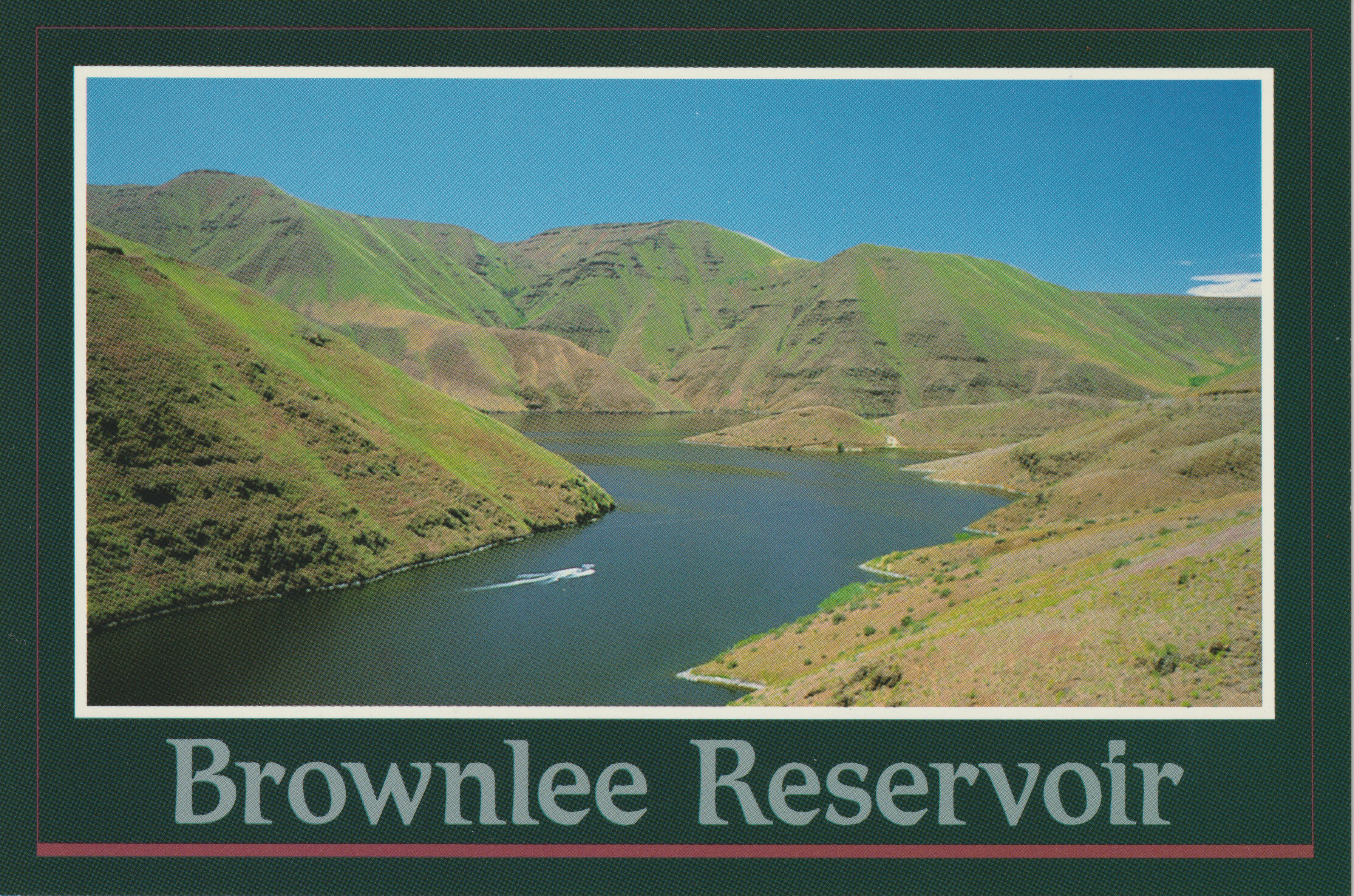
 Brownlee Reservoir, Hells Canyon, Baker Co., Oregon/Washington/Idaho


Brownlee Reservoir is the featured photograph on this Smith-Western, Inc. postcard.  The photo is by Robert J. Franzese.  There is a blurb at the upper left corner on the reverse: “The backwaters from Brownlee Dam reach nearly 60 miles upstream to Farewell Bend near Weiser, offering the fisherman and pleasure boater an unlimited playground. “  The code:  ID-6295 is found under the blurb.


Brownlee Dam and Reservoir are named after John Brownlee who started a ferry service that crossed the Snake River between Idaho and Oregon, known as Brownlee’s Ferry.  After the railroad was built a station was established at the ferry site and also named Brownlee.  A post office operated here off and on between 1910 and 1965.  The rail line was removed by the Oregon Short Line railway in 1934.  The unincorporated community of Robinette was the terminus for the Union Pacific aka Oregon Short Line.  The site of that former community was flooded when the reservoir filled in May 1958 and is today underwater.


Brownlee is a hydroelectric earth fill embankment dam on the Snake River at the Oregon and Idaho border.  It is part of the Hells Canyon Project that also includes Hells Canyon Dam and Oxbow Dam, and is operated by the Idaho Power Company.  The reservoir is 58 miles or 93 km long.  The powerhouse has five generating units with a capacity of 585.4 megawatts. 


There is no passageway for migrating salmon on this stretch of the Snake River from Hells Canyon Dam up to Shoshone Falls.  Shoshone Falls is a natural barrier to fish passage to the upper Snake basin.  


Shoshone Falls, Twin Falls, Idaho, 2022


For additional information, see:


https://en.wikipedia.org/wiki/Shoshone_Falls

https://en.wikipedia.org/wiki/Brownlee_Dam

https://en.wikipedia.org/wiki/Robinette,_Oregon

https://en.wikipedia.org/wiki/Brownlee,_Oregon


Thursday, September 1, 2022

If this is Thursday it must be postcards, 571


Lizard Butte, Marsing, Idaho, ca 2008


This postcard has a photograph of Lizard Butte by Rhonda McCarvel.  The card is a product of Mountain West Prints, Great Mountain West Supply, S.L.C., Utah [postcardsamerica.com].  There is a blurb on the reverse at the upper left corner:  “Lizard Butte is located on a small piece of land between the Snake River Basin and the Owyhee Mountain Range East of the city of Marsing.  This is considered one of Idaho’s “natural wonders.”  Geologically Lizard Butte is a half crater, but the early pioneers named the formation Lizard Butte because of its resemblance of a large lizard.”


Looking at the photograph it was not immediately apparent to me that this was "a lizard basking in the summer sun" on the top of the butte.  On closer examination, it is possible to discern the head facing to the left and just below that an arm or leg-like appendage with the remainder of the body, rear leg and tail, continuing down the right side of the hill.  This is one of the historic sites on the Oregon Trail and is located just outside Marsing, Idaho.  The butte is about 350 feet or 106.68 meters high.  The surrounding farm land contains mostly orchards.  Today, Marsing, a small community, is part of the Boise metropolitan area. 


Sunrise Easter Services have been held here since 1938.  The idea to hold Easter sunrise services here was suggested in the spring of 1937 by Marsing residents, Ray and Marion Stafford, who could see the butte from their home window and thought it would be an ideal place to hold such an event.  Representatives from several communities formed the Lizard Butte Easter Sunrise Association and made plans to hold sunrise services.  The hillside was terraced for seating, a platform was built and a wooden cross was erected on the lizard’s head for the first service held 17 April 1938.  About 1,000 people attended that first service.  Unfortunately, two years later the cross was burned by vandals.  A cross of reinforced concrete replaced the original wooden cross and it is still standing above the valley floor today.   


The Association purchased the 40 acres of Lizard Butte to ensure that the services could continue each year.  Each Easter service follows a pattern, first with a bugle call and the appearance of two angels at the foot of the cross.  Many local churches, groups and organizations have donated time and money to help perpetuate the sunrise services.  Continued vandalism resulted in fencing and gating the property.   Thousands of visitors have attended Easter services here during the more than eighty years they have been offered.


For additional information, see:


https://en.wikipedia.org/wiki/Marsing_Idaho

https://lizardbuttesunrise.com/HISTORY

https://www.roadsideamerica.com/tip/45400


Thursday, August 25, 2022

If this is Thursday it must be postcards, 570


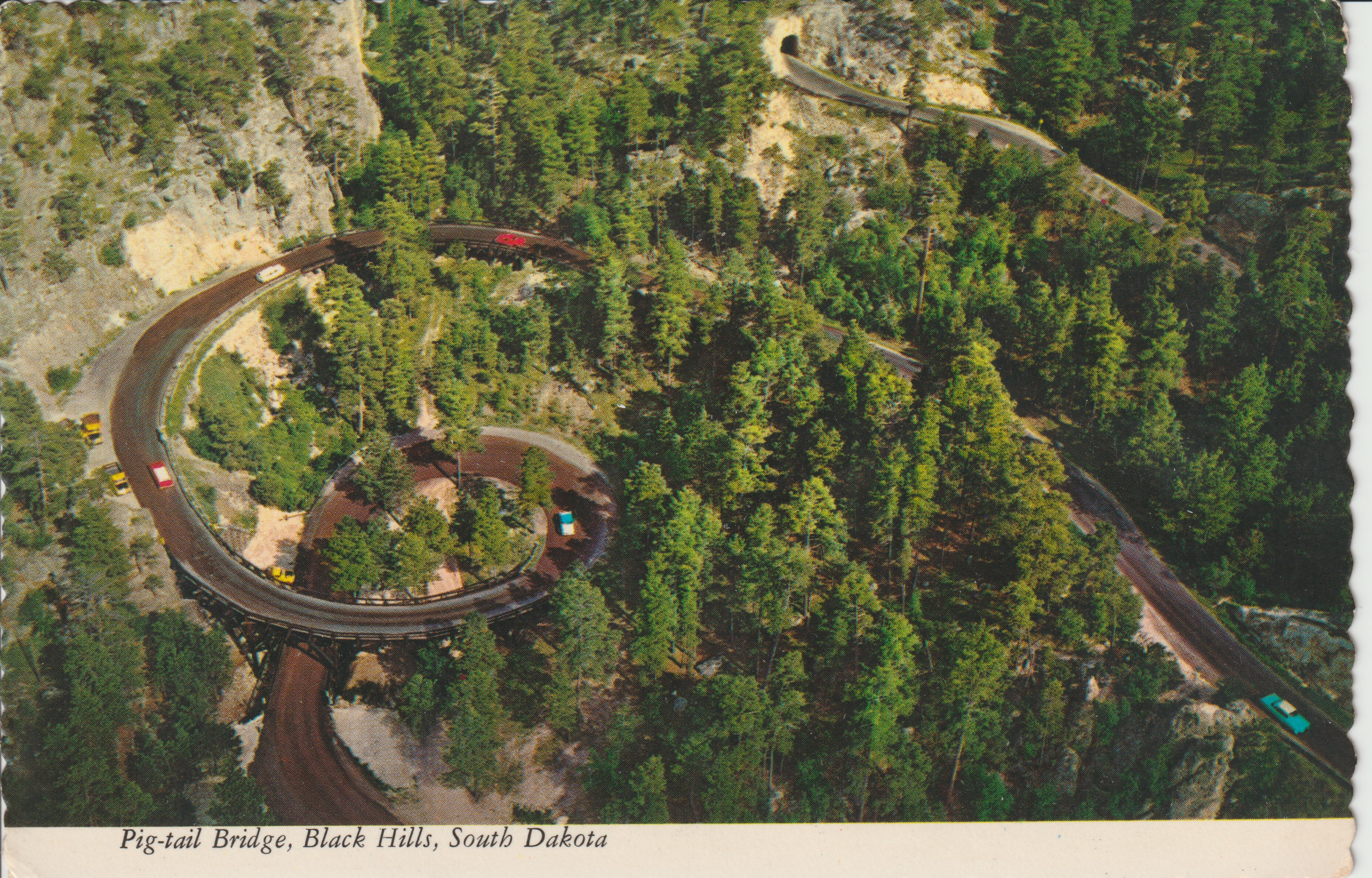
An aerial view of the Pig-tail Bridge, Black Hills, South Dakota


This postcard has a photograph by Jack Riodan showing an aerial view of the Pig-tail Bridge in the Black Hills of South Dakota.  It is a Plastichrome by Colourpicture, Boston, MA product distributed by Rushmore Photo Inc., of Rapid City, South Dakota.  It is the type of card that has scalloped edges.  I found the card at a local antique pavilion and since we had visited here in 2017, it was one I wanted to add to the collection.


There is a 17 mile stretch in the Black Hills called the Iron Mountain Road (16A).  The road was specifically designed with curves, or switchbacks, to slow drivers down and has a speed limit of 35 mph.  The slower speed allows for time to enjoy the wonders of Mother Nature from the scenery itself to the animals, like bison, big horn sheep, antelope, deer and even wild turkeys.  Mt. Rushmore is at one end of the road and Custer State Park at the other end, both often visited tourist destinations.  There are several tunnels too.  It takes about 45 minutes at least to drive the 17 miles.  We stopped more than once to take pictures and enjoy the landscape.


Eye level view of part of the Pig-tail bridge. 


The Pig-Tail bridges are wooden structures.  The photo shows the curvature and the under structure. There are several one lane tunnels that were bored straight through the huge rocky outcrops.


Approaching a one lane tunnel


The curving road to encourage slow driving


The Needles Eye rock formation


Another one lane tunnel through rock.   This one is near Needles Eye.


Baby mountain goats


Bison grazing


Dark eyed Susan daisies


Deer

Antelope

Custer State Park and wildlife preserve covers over 71,000 acres that includes rolling prairie grasslands and rugged mountains.  The wildlife and scenery are amazing. 


For additional information, see:


https://www.ironmountainroad.com/

https://en.wikipedia.org/wiki/Custer_State_Park


Thursday, August 18, 2022

If this is Thursday it must be postcards, 569


Corn Palace, Mitchell, South Dakota, ca 1950s


Two postcards are shared this week.  The card above shows the exterior of the Corn Palace in Mitchell, South Dakota.  From Dan Grigg Enterprise Co., Mitchell, So. Dakota the card uses a “Curteichcolor” reproduction from Kodachrome original.  The blurb at the upper left on the reverse:  “The World’s Only Corn Palace, Mitchell, South Dakota.”  I found these cards in an Antique Pavillon. The Corn Palace was a place we visited in 2003, so at the bargain price 25 cents each, they got added to the growing collection of postcards. 


Beginning about 1887 to the early 1930s crop palaces were built across the Midwest United States to promote the place and the products.  In 1892 the original Mitchell Corn Palace, also known as "The Corn Belt Exposition,” was built over a wooden frame to showcase the rich soil and encourage people to settle in the area.  Of all those built, today only the Mitchell Corn Palace remains intact.  Louis Beckwith, a member of the First Corn Palace Committee, donated land.  The Corn Palace was rebuilt in 1905, 1921, and again in 1937.  In 1937 the Russian-style onion domes and Moorish minarets were added.  In 2015 shaking from strong winds necessitated the renovation and building of new domes. At the same time turrets were constructed of architectural metals.


The exterior murals are replaced and redesigned each year with new themes and designs created by local artists.  Twelve shades of natural corn are gown by local farmers to create the artwork.  All the murals covering the building are made from corn and other grains.  From 2003 to 2017 the murals were designed by Cherie Ramsdell.  No new mural was created in 2017 due to an extreme drought.  Beginning in 2018 the designs have been created by Dakota Wesleyan University students.  The designs are transferred to black tar paper labeled with codes for colors, rather like a paint by number system.  It takes about 1.5 million nails and 325,000 ears of corn to decorate the exterior of the building.  Currently it costs about $175,000 each time it is redecorated.


The venue is a multipurpose arena and facility where they have concerts, sports events, exhibits, and community events.  In past times a citywide festival was held the end of September, that was recently changed to the end of August. The building is open free to the public.  Inside there are murals on the walls like the one shown on the second postcard below.


From the interior, World’s Only Corn Palace, Mitchell, South Dakota, ca 1950s-1960s.


This is another Dan Grigg Enterprise Co., product with Genuine Curteich-Chicago, C.T. Art Colortone," and has a blurb at the upper left corner on the reverse:  “One of the many panels on the inside of the world’s only Corn Palace.  These panels are made from natural-colored grains and grasses.  The entire building is redecorated annually at a cost [then] of $10,000.  The annual festival is held the last week in September, but the building is open Free the year around.  It is one of the most outstanding exhibits of nature’s wonderful colors blended into interesting designs and pictures by local decorators.”  Based on the difference in cost to do the redecorating it is estimated that this card comes from the 1950s or 1960s.


Exterior design in 2003, Corn Palace, Mitchell, South Dakota


The Corn Palace is a popular tourist destination and receives approximately 500,000 visitors each year.  There are exhibits and local artist sales inside the building when it is not being used for special events.


For additional information, see:


https://en.wikipedia.org/wiki/Corn_Palace


Thursday, August 11, 2022

If this is Thursday it must be postcards, 568


Poi ball dance of Maori, Polynesian Cultural Center, Oahu, Hawaii


This unused postcard is another IMPACT “Life Like Photo Art” publication, 1979.  John Wagner is credited with the color photograph.  At the lower left corner on the reverse is #1570-H. 


The Maori are indigenous people of main land New Zealand (Aoteraroa) who originated as settlers from East Polynesia and arrived in New Zealand in several different canoe voyages between 1320 and 1350 AD.  Due to their isolation, they developed their own culture, language, mythology, crafts and performing arts independent from the other easter Polynesian cultures. 


The poi performance art is named for the equipment used.  Poi is a skill toy that involves swinging tethered weights through a variety of geometric and rhythmical patterns.  The performers may also sing and dance while swinging their poi.  Different materials, weights, handles, and effects (like fire) can be used.  Poi originated with the Maori people where it is still practiced today.  The word poi can be used to represent the object, the choreography or the music.  Sometimes the outer shell had a pattern based on a fishing net or were dyed yellow to form diamond patterns.  Most spinners learn poi from each other.  Legends say that men first used poi to develop wrist flexibility for the use of hand weapons but no evidence has been uncovered to substantiate the story. 


For additional information, see:


https://en.wikipedia.org/wiki/M%C4%81ori_people

https://en.wikipedia.org/wiki/Poi_(performance_art)


Thursday, August 4, 2022

If this is Thursday it must be postcards, 567


 Tahitian dancer, Polynesian Cultural Center, Oahu, Hawaii


This is another unused postcard from the Polynesian Cultural Center.  The photograph of this Tahitian dancer is credited to John Wagner.  The card is an IMPACT publication with “Life Like Photo Art,” published in 1979.  The numbers #1569-H and G-1439 appear at the lower left corner on the reverse.


Tahiti is one of the cultures represented in the Polynesian Cultural Center (PCC) villages.  The nearest land mass to Tahiti is Australia.  Tahiti is divided into two parts, northern and southern, and like Hawaii was formed by volcanic activity.  The first people came from Western Polynesia before 500 BCE.  Before the arrival of Europeans one clan dominated several divided territories that stretched from the south to north.  Clan leadership included a chief, nobles, and under-chiefs.  Belts of feathers were used as symbols of power.  The fist Europeans to arrive at Tahiti may have been led by the Spanish explorer Juan Fernandez in 1576-1577 or a Portuguese navigator, Pedro Fernandes de Queiros, who sited an inhabited island in 1606.  By the late 1700s many other Europeans had arrived including whalers and merchants some of whom brought infectious diseases and introduced alcohol.  These commercial interactions had catastrophic consequences for the Tahitian population.  Paul Gauguin, the French impressionist artist, lived on Tahiti in the 1890s where he painted many Tahitian subjects.  There is a small Gauguin museum dedicated to his life and works in Papeari. 


Tahitian culture included an oral mythic religious tradition, tattooing, navigation, dance, music, sports, such as long-distance outrigger canoe races between the French Polynesian islands.  The Tahitian dance is world famous represented by fast hip-shaking and grass skirts. 


 Pageant of Canoes, Tahitian dances, Polynesian Cultural Center, Oahu, Hawaii


At the PCC there is a parade of canoes with the various islands represented.  The card above is a Hawaiian Series distributed card by Royal Mini Print, and features a photograph of Tahitian dancers at the Pageant of Canoes.  The number B9507 appears at the lower left corner on the reverse.


For additional information, see:


https://en.wikipedia.org/wiki/Tahiti