An aerial view of the Pig-tail Bridge, Black Hills, South Dakota
This postcard has a photograph by Jack Riodan showing an aerial view of the Pig-tail Bridge in the Black Hills of South Dakota. It is a Plastichrome by Colourpicture, Boston, MA product distributed by Rushmore Photo Inc., of Rapid City, South Dakota. It is the type of card that has scalloped edges. I found the card at a local antique pavilion and since we had visited here in 2017, it was one I wanted to add to the collection.
There is a 17 mile stretch in the Black Hills called the Iron Mountain Road (16A). The road was specifically designed with curves, or switchbacks, to slow drivers down and has a speed limit of 35 mph. The slower speed allows for time to enjoy the wonders of Mother Nature from the scenery itself to the animals, like bison, big horn sheep, antelope, deer and even wild turkeys. Mt. Rushmore is at one end of the road and Custer State Park at the other end, both often visited tourist destinations. There are several tunnels too. It takes about 45 minutes at least to drive the 17 miles. We stopped more than once to take pictures and enjoy the landscape.
Eye level view of part of the Pig-tail bridge.
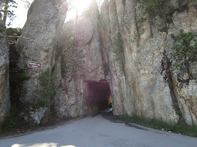
The Pig-Tail bridges are wooden structures. The photo shows the curvature and the under structure. There are several one lane tunnels that were bored straight through the huge rocky outcrops.
Approaching a one lane tunnel
The curving road to encourage slow driving
The Needles Eye rock formation
Another one lane tunnel through rock. This one is near Needles Eye.
Baby mountain goats
Bison grazing
Dark eyed Susan daisies
Deer
Antelope
Custer State Park and wildlife preserve covers over 71,000 acres that includes rolling prairie grasslands and rugged mountains. The wildlife and scenery are amazing.
For additional information, see:
https://www.ironmountainroad.com/
https://en.wikipedia.org/wiki/Custer_State_Park


No comments:
Post a Comment