Thursday, May 31, 2018

If this is Thursday it must be postcards, 353


Lunchroom cafeteria, Carlsbad Caverns, New Mexico, ca 1940s

The lunchroom in the Carlsbad Caverns National Park, New Mexico is featured on this unused Linen-Type postcard.  It is labeled as a genuine Curt Teich, C.T. Colortone, postcard distributed by Herman Hemler of Carlsbad, New Mexico.  As mentioned previously, Linen Type cards were popular during the 1930s through the beginning of the 1950s.   The paper used had a higher rag count and produced a linen-like appearance that is also noticeable to the touch.  The Colortone process produced rich colors.  Curt Teich of Chicago postcards usually have an alpha-numeric code from which the year of issue can be determined.  This card has the Helmer number of 114 and the C.T. number 9B-H1472 on the reverse in the box labeled for a stamp. 

The lunchroom was built in the big cavern room, called Big Cave or The Hall of the Giants, in 1928, two years before the cave became a national park.  Although food is no longer cooked in the cave, sandwiches, salads, desserts and other food not requiring cooking as well as soft drinks and hot drinks are still served.  Originally visitors to the caves had to hike for approximately 6 hours to reach this large cavern; hence a place to sit and eat was very popular.  As it turned out cooking food in the caverns was not a good idea as it began to drastically change the Eco-system and also attracted unwanted animals like raccoons, ringtail cats, and skunks.  The park service has been trying to close it; however, the lunchroom is privately owned and operated. So far any attempts to close it down has met with opposition from local businessmen and politicians who want to keep it open. 

In 1932 the national park added two elevators so that people would not have to walk down and back up the long switchback ramp to the big cavern located 750 feet or 230 meters below the surface.  A museum, first aid area, and restrooms are also to be found in the large cavern that holds the lunchroom.  It is possible to purchase and mail postcards cancelled with “Mailed from 750 feet below ground.” 

Discovered by a boy named Jim White, who explored the cavern system descending by a homemade wire ladder, today the caverns are open year round with a constant temperature of 56 degrees F or 13 degrees C.  White named many of the 23 areas within the cave system including the Big Cave also known as The Hall of the Giants.  The Bat Cave is home to the majority of bats who inhabit the caves.  Bat guano was mined there in the early 20th century.   Unfortunately, the lights installed to aid tourists are not helpful to the native bats who will not go out to feed in the evening or come home to roost in the morning when the lights are on in the lunchroom.  They need the darkness.

For more information, see:

https://www.collectorsweekly.com/postcards/linen
http://www.thepostcard.com/walt/curt.html
http://www.amusingplanet.com/2014/01/carlsbad-caverns-underground-lunchroom.html
https://en.wikipedia.org/wiki/Carlsbad_Caverns_National_Park

Thursday, May 24, 2018

If this is Thursday it must be postcards, 352


Fish Creek, Chelan County, Washington, ca 1930

Alfred G. Simmer was the photographer of the Black & White picture on this 1930s postcard.  The name Simmer and the place are written in white at the lower left of the card.  It is identified as Fish Creek, Chelan, #191.  My grandmother, Lil Anna Hornnes Schroder received this card from her brother John as a Christmas and New Year’s greeting in 1930.  The rushing water of this creek or river may have reminded both of them of the Otra River in southern Norway where they grew up. 

Fish Lake is a small lake located northeast of the larger Lake Wenatchee.  On a current map there is a creek or small river exiting Fish Lake called Fish Lake Run and I think it is possible that it may have been called Fish Creek when this card was published.  Both lakes and nearby rivers and streams are known to be good fishing areas.  Today outdoor activities near Wenatchee include hiking, water skiing, kayaking, windsurfing and swimming.  Nearby trails are open to hikers, bikers, horseback riders and there are areas for rock climbing as well.  In the winter Wenatchee State Park is used for cross-country skiing, dog sledding, snowmobiling, and ice climbing.  


There is a brief biography of Simmer, titled "Simmie," on Ancestry.com by Bill Miller, as part of Public Member Stories.  That plus the picture of Alfred G. Simmer, above, was taken in Alaska, both appeared in an article from Highway News, a publication of the old (Washington State) Department of Highways; From Highway News Feb 1953, v. 2 no. 8.  It was unexpected and fun to find a picture of the photographer.

As a photographer, Simmer, is known mostly for the pictures he took in Alaska of Eskimos and local scenes between 1905 and 1907.  His wife appears in several of the photographs he took while living in Alaska. 
I wondered what happened to him after 1907.  He turns out to have had an interesting and varied life.  Born in Germany he came to the United States at about age 15 and lived with his aunt and uncle in San Francisco while he continued his education.  He was a drafter and civil engineer as well as a photographer.  He married Mary Louise (Mitzie) Setil in Seattle 1903 and soon after they moved to Nome, Alaska where they built a home.  Both of their children were born while the family lived in Alaska, a son, Edwin, in 1905 and a daughter, Dorothy, in 1908.  After they left Alaska they moved back to Seattle in 1910 where they lived for several years before moving to Wenatchee in 1922. 

It was while they were in living in Wenatchee that Simmer became self-employed as a portrait and commercial photographer.  After 17 years of studio photography work he went to work in Olympia, Washington for the Highway Department in the Bridge Division and the Planning Division doing special photography work.  Sometime after his wife passed away in he moved to San Joaquin, California.  His two adult children were married by then and living not far away in the San Francisco Bay area, Edwin in Santa Cruz and Dorothy in Navato.  Alfred George Simmer was born in Danzig, Germany 11 February 1874 and passed away 15 April 1958.   Mitzie was born in Vienna, Austria in 1882 and passed away 25 April 1946 in Olympia, Washington.


For more information, see:

https://en.wikipedia.org/wiki/Lake_Chelan
https://en.wikipedia.org/wii/Lake_Wenatchee_State_Park
Ancestry.com

Thursday, May 17, 2018

If this is Thursday it must be postcards, 351


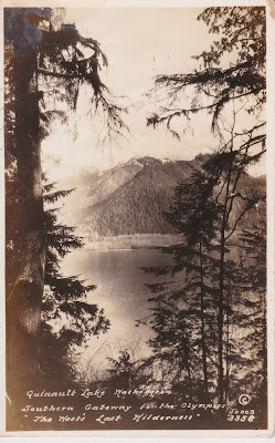
Lake Quinault, Washington, ca 1933


The Jones Photo Co. of Aberdeen and Hoquiam, Washington published this Black & White vintage card with a picture of Lake Quinault with the Olympic Mountains in the background and trees in the foreground.  Jones and an identifying number of 3358 found at the lower right corner.   


Logo of the Jones Photo Co., Aberdeen & Hoquiam, Washington found on the reverse of the card

Beginning with William L. Jones, a Welsh immigrant, four generations of the Jones family owned and operated the business from 1880, in Silverton, Oregon, moving to Washington in 1913, until 2003 when the Anderson & Middleton Company purchased it retaining the grandson of the original founder, Bill Jones, as advisor.  Over 175,000 glass and film negatives and 85,000 prints now form a historical collection of photos of northwest Washington. 

Many of the pictures depict scenes from everyday working life as well as the buildings, boats, just married couples, babies, and tribal chiefs.  Since this postcard does have a number, I had hoped that the Jones Photo Historical Collection online would have an index and it would be possible to discover who took the picture.  While there is a search function, and I tried several different options to search; however, this particular picture does not appear to be in the collection.  Because the message and postmark at dated 1933 it is likely that either William L. Jones or his son Bliss, took the photo.  The grandson, Bill Jones, would have only been 11 years old and although he had started taking pictures that year it not as likely he took this one. 

Lake Quinault is located within the Rain Forest on the Olympic Peninsula of Washington.  The Quinault Indian Nation owns the land and the area is accessible from the coastal U.S Route 101.  There are some day-hiking trails maintained by the Forest Service, fishing in the lake is allowed with a permit from the Quinaults, and there is a scenic loop drive around the lake.  In addition to the historic Lake Quinault Lodge there are also campgrounds.  


1933 one-cent commemorative stamp featuring Fort Dearborn

The U.S Postal Service issued two stamps in 1933 to commemorate the Chicago World’s, A Century of Progress, including this one-cent green stamp with Fort Dearborn featured on it.  The original Fort Dearborn was built in 1803 and was destroyed during the War of 1812.  A new fort with the same name was constructed on the same site in 1816 and decommissioned by 1837.  The remains of that fort were lost in the Great Chicago Fire of 1871.  Today the site is a Chicago Landmark.  A replica of Fort Dearborn was erected as an exhibit for the Chicago World's Fair in 1933.

For additional information, see:

http://www.jonesphotocollection.com/kiosk/about.html
https://en.wikipedia.org/wiki/Lake_Quinault
https://en.wikipedia.org/wiki/Lake_Quinault_Lodge
https://en.wikipedia.org/wiki/Century_of_Progress
https://en.wikipedia.org/wiki/Fort_Dearborn

Friday, May 11, 2018

East Fork Foss River, 2018


Trilliums

We have hiked here a couple of times; the most recent was about 2 years ago.  This time we set a goal of reaching the River Camp, about 3 miles in for a 6-mile roundtrip.  Our car was the only one at the trail head when we arrived, we saw no other hikers or dogs and the car was still the only one there when we returned.


Very tiny patch of snow

Unfortunately, we were not able to meet our planned destination.  There were still a few tiny patches of snow off to the side but those were not a problem.  This trail does have a bridge over Burn Creek (more like a river) that was running fast.  It also has a number of smaller creek crossings that have to be forded.  I lost count of the number of creeks we crossed, some were just little bitty streamlets others were full of loose rocks and fast running water. 


 The large downed tree that fell directly on the trail

In one place a large tree had come down right on the trail and we had to scramble around and just follow the tree up until we could see the trail again.  The last creek was too deep for us to cross without water coming into our boots and part way up our legs.  It had a high degree of hazard that we were unwilling to take.  The water was running fast, cold, and the rocks were loose and slippery.  We tried several different places to see if a shallower, safer crossing could be possible to no avail.  It was frustrating to see the trail continue on the other side of the water and not be able to safely reach it.  We were within 1/3 to ½ mile of our hoped for warm lunch spot on the river bank and had to turn back. 


The old bridge over Burn Creek


The new wooden bridge over Burn Creek


This is a creek?  Looks more like a raging river!

The trail is not up one way and down the other instead it goes up and down almost all the distance with some level terrain here and there.  The day was hot, almost 80 degrees F, not optimal temperature for hiking. 


 Trillium in white, new bloom stage


 Starting to turn pink


Nearing the end of the bloom, turning purple-pink

One of the reasons we chose this hike was to see the trilliums and orchids.  Last time we saw about 50 of the shy Calypso orchids including the rare white one.  This time we counted 72 and think we may have missed some so the count may be closer to 75 or more.  There were hundreds of trilliums, some in massive displays of over 50 growing in large patches under trees.  They were in various stages of blooming with some the brilliant white and others changing to pink and eventually dark purple.  We wondered if we would find the white calypso and we did.  Bob had noted in his hiking journal that he had seen it 6 years ago, and we saw it again 2 years ago.  It probably isn’t as pretty as the purple-pink normal color but this albino orchid is very rare and exciting to find.


 Cluster of Calypso orchids (about 3" tall, flower is about 3/4" across)


 Calypsos can grow in groups but are usually spaced somewhat apart from one another although we did see pairs like these below


To our delight, the elusive white Calypso


Fairybells


 Skunk Cabbage


 Salmonberry


Red Huckleberry flowers.  The Red Huckleberry plant has green branches and leaves, tiny little flowers.  The only wild red berry that is safe to eat for sure.

Once the spring runoff has lessened and the water level has gone down a little it should be possible to safely ford the stream that stalled our progress; however, all the trilliums and orchids will have long finished blooming.  One unexpected wildlife sighting was a Great Horned Owl who hooted at us several times before taking flight.  We didn’t see it was until it was flying away.  And as it was flying fast we didn’t get a picture.  The wingspan was impressive. 


Conks growing on a downed tree


 These conks were climbing up the dead tree stump like steps


Tall conifers--Douglas Fir and Western Hemlock


Trailhead sign

Stats:  A no dog day! The first, I think.  No other hikers, also a first.  Approximately 5 ¼ miles round trip (it seemed longer, probably because it was such a warm day) with a vertical gain of about 700 ft counting all the ups and downs.  


Thursday, May 10, 2018

If this is Thursday it must be postcards, 350


Longmire Springs Hotel, Rainier National Park, ca 1910

This photo postcard dates from about 1910 when the Longmire Springs Hotel opened as a health resort.  There are no identifying marks to indicate the photographer or the publisher of the card.  It is unused.  The dating is based on the length of the skirts the women in the picture are wearing and the new appearing condition of the hotel. 

As early as 1889 James Longmire built guest cabins and later the rustic two-story hotel shown on the card.  His son, Eclaine, added on to the hotel and also built bathhouses and barns.  The family had a mining claim before the park was established so the park management had little control over how the hotel looked or how it was run.  Arguments about the appearance and operations developed and the park offered to buy the land and buildings in 1902 but the Longmires refused to sell.  It wasn’t until after the death of Eclaine in 1915 and the Longmire Springs Hotel Company Hotel Company took over operations in 1916 that any changes were made.  That same year the park started building the Paradise Inn and also was able to begin buying the Longmire buildings.

Before the era of park lodges like Old Faithful Inn in Yellowstone Park, many of the hotels or lodges were wood frame structures like this one that were cheaply built on blocks instead of true foundations.  The result was after a few seasons the roofs would sag, the floors would no longer be level and no amount of new exterior paint could fix the increasing disrepair.  At some point Longmire Springs was called the “ultimate decrepit mountain resort hotel.”   A second, larger hotel was added in 1906 but it burned down in 1926.  The Annex was added to the property in 1916.  The 1916 structure was much better built and survives today as The National Park Inn. 

The nearby mineral hot springs were thought to be beneficial and a curative for a variety of ailments.  Approximately 500 people visited the springs a year.  Water temperatures reached 85 F or 29 C.  Ironically the mineral springs had no proven health benefits and some time later notices warned that the water might cause sickness. 

Today, except for the 1916 National Park Inn building and Eclaine Longmire’s reconstructed cabin, little remains of the once popular resort.  The meadow is returning to its natural pre-resort condition, there are wild flowers, and there are places where the hot spring water still comes out of the ground and runs down the hillside.   


We have hiked in this area a couple of times and found signs posted providing some local history and also warnings about the water.  


The soggy meadow with ill smelling mineral spring water


For additional information, see:

http://www.arroyorain.com/2011/05/14/mt-rainiers-longmire
https://www.nps.gov/articles/the-national-park-inn.html
https://en.wikipedia.org/wiki/Longmire,_Washington
http://www.nplas.org/longmiresprings.html

Saturday, May 5, 2018

What’s for dinner? Fried motherboard . . .


New, out of the box

For several months I have known that time was running out for my aging computer.  A couple days ago while I was working on it, everything went black.  The re-boot process could not complete and the computer sat there in mocking dark silence.  There was a moment or more of sheer panic as I realized all my genealogy, photos, written rough drafts, and correspondence was now in that black hole and currently inaccessible.  I called my ever helpful and patient son and described the situation.  The battery on that laptop had worn out at least a year ago and I had the computer plugged in day and night to the power strip.  Yes, he knew what was wrong.  The motherboard was fried.  By having it plugged in all the time the motherboard had gotten too hot and essentially burned up—fried.  Fortunately, I had backed up to an external drive just a few days earlier so I knew I had not lost too much and he assured me that all the data, even the recent work not backed up, was still on the hard drive and could be retrieved. 

Bob and I went down to the Apple Store in the Village and explained what happened.  We had the old laptop in the carry bag with us.  When I mentioned that the computer was 9 years old and asked about retrieving data and transferring the software the salesman called over another person to confer.  Part of that conversation went something like, “this lady has an ancient old computer . . .” 

I had determined before I went into the store that there was absolutely no reason to try and repair the laptop because of its age.  It was at least two operating systems behind and too old update.  The two guys at the store agreed.  We didn’t even try to look and see what was the matter with it.  Since I did have a fairly recent backup and wouldn’t be losing too much it was suggested that I just restore the backup to the new machine and see what happens.  I told them I would keep the old computer just in case I had to come back and get help extracting something critical from the hard drive.  Once again they agreed that this was a good strategy.

End result, I am writing this from a new laptop with a slightly smaller screen but one that is much newer, faster and lighter in weight.  So far everything is working okay but I am anticipating a few hitches with some of the older software.  I opted for the 13” MacBook Air instead of trading straight across to another 15” MacBook Pro for a couple of reasons.  The new Pro has different sized ports and I would need to get adapters for any USB connectors.  The Air still has the slot for photo memory cards while the Pro does not.  It was also slightly less expensive. 

After some nervous moments during the set up process, everything seems to be working.  I didn’t lose much data, and I am adapting to the smaller screen without difficulty.  Phew!  I don’t want fried motherboard for dinner again. 


Up and at least partially running

Thursday, May 3, 2018

If this is Thursday it must be postcards, 349


Camel drivers, Baalbeck, Lebanon, ca 1970


Jack P. Dadian of Beirut, Lebanon published this postcard with a color photograph of camel drivers.  On the reverse at the center bottom has a logo with Kruger in a circle and the number 987/83.  A friend who travels to the most interesting places sent this card to us many years ago.

Baalbeck or Baalbek is a city with a population of almost 83,000 located in the Anti-Lebanon foothills, the snow covered mountains in the background of the photo.  It is about 53 miles or 85 km from Beirut and 47 miles or 75 km from Damascus. 

People have been living in this valley for over 8,000 years.  Among the many ruins in the area are the six columns in the center of the photo from what was at one time a huge Roman Temple of Jupiter that was started in the 1st century and completed in the late 2nd or early 3rd century.  The pillars are 312 feet or 95 meters high.  In past times the temple was pillaged for its stone and suffered damage from earthquakes; however, the south facing side of these remaining six columns is in almost perfect condition while the north side has been worn almost bare by the wind.

The two stamps on the postcard were also interesting.  The one shown immediately below has a commemorative stele of Nahr al-Kalb high on the hill.  Apparently conquerors would build monuments at the mouth of the river.  The one on the stamp is “Christ the King,” and overlooks the river basin.  The stamp was printed in 1966.


Nahr-el-Kalb, Lebanon, stamp 1966

The second stamp has the famous landmark called Pigeons’ Rock, also known as the Rock of Raouché or just Raouché, that is found at Beirut’s western tip.  The rocks are a popular tourist destination.  The stamp was printed in 1967.


Pigeons’ Rock, also known as the Rock of Raouché or just Raouché, stamp 1967


Thank you V for sending the card "way back when."  It was fun to rediscover it and be able to share it here on the blog.

For additional information, see:

https://en.wikipedia.org/wiki/Camel
https://en.wikipedia.org/wiki/Temple_of_Jupiter_(Roman_Heliopolis)
https://en.wikipedia.org/wiki/Baalbek
https://en.wikipedia.org/wiki/Nahr_al-Kalb
https://en.eikipedia.org/wiki/Raouché

Wednesday, May 2, 2018

Stan’s Overlook, 2018


Sign at the trail head

Stan’s Overlook on the Rattlesnake Mountain trail is approximately a 5-mile round-trip hike with 1050 feet elevation gain.  Note:  the sign at the trail head says 1.9 miles to the overlook but the Green Trail map says 2.5 miles.  We calculated the round trip to be closer to 5 miles than 4.  On a clear day there is a nice view between the trees of the valley below but it was not a clear day when we went this time so we were amid the clouds and had no panorama view.  


 Sorry, no panorama view today, we're in the clouds . . .


a little down from Stan's in the power line, still in the clouds

Parallel bike trails cross the hiking trail in a few places near the gates.  We met and talked with a couple of mountain bikers.  Bikes are not allowed on the hiking trail.  There are also separate trails for horses.  New bike trails are being added and should open around the 19th of May.  When we were there a trail crew of 6 guys were building a kiosk at the junction turn off to Stan’s.  If one were to continue two miles upward from the junction to Grand Prospect, this would be a 9-mile round trip hike.  The bike trails are not as steep as the hiking trail and offer a longer trip down.  From Stan’s we could see that the crew had also put in some bumps for trick riding.


Salmonberry


 Trillium--drenched with rainwater the petals are almost transparent


 This trillium was large and spectacular!


Bleeding heart


 Dozens of these large and smaller currant bushes


 Closer look at the currant blossoms


 Fringe cup


Devil's club just beginning to leaf out


Oregon grape


Yellow stream violet

The usual early flowers were out, trillium, fringe cup, salmonberry, red currant, elderberry, Oregon grape, bleeding heart, and yellow stream violets with promise of lily of the valley; vanilla leaf, Solomon seal, devil’s club and fireweed just leafing out but not in flower yet.    


Bob standing by a giant tree stump

This area had been logged once upon a time and there are some giant old stumps to be found here and there.  


general trail condition


 There are stairs like these in a couple of places


 Gates like this one can be found in several places.  They are designed to deter bikes and horses from the trails designated for hikers only.


Wider section of the trail


 Moss covered branches

The trail condition was good, only one log to climb over, and even though it has been raining a lot there only a few muddy areas.  It is wide enough for two people to walk side-by-side in places but more narrow in others with some fairly steep sections.

Stats:  3 hikers, 3 mountain bikers, 6 trail crew members and one huge, black lab trail crew dog wearing a day-glow orange jacket just like the rest of the crew.