Thursday, April 24, 2025

If this is Thursday it must be postcards, 708


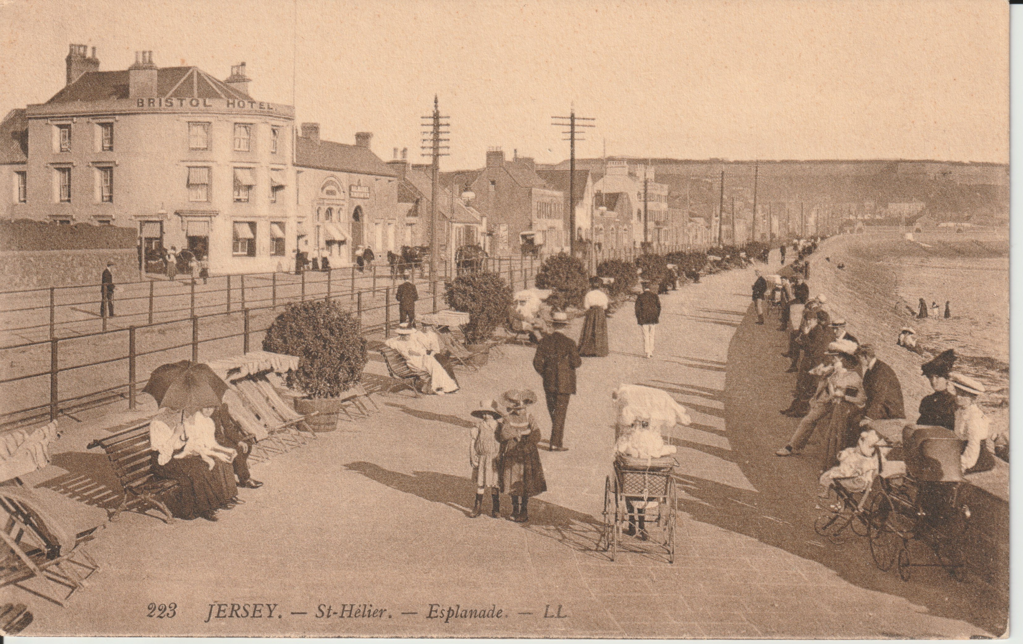
St. Hélier, Jersey, Channel Islands, ca early 1900s


These two sepia toned cards are souvenir picture postcards produced by one of the most important postcard editors in France during the golden age of postcards, Léon & Lévy or L.L.  L.L. was founded in 1864.  The initials L.L. were registered as a trademark in 1901.  The cards have divided backs, dating them to after 1902.  The card above has the number 223, and the title at the bottom left.  It shows the esplanade or wide walkway alongside the beach. 


Both cards offer a view into the past, showing people in typical dress of the time.  In this one there are horse drawn carriages seen between the hotel level and walkway, baby carriages, children, adults, and beach chairs. 


The second card, below, shows the front of the Grand Hotel and part of the long esplanade.  The number 50 and the title appear at the upper right corner.  A gated ramp leads down to the beach.  Men’s clothing has not changed much in over 100 years.  However, neither men nor women today would be wearing such long, warm clothing to a beach today. 


Grand Hotel, St. Hélier, Jersey, Channel Islands, ca early 1900s


St. Hélier is the capital and only city of Jersey, the largest of the Channel Islands in the English Channel.  The town is named after a 6th century hermit monk, Helerius, who converted the people on the island to Christianity and was later martyred by Saxon pirates in 555 A.D.  The Hermitage, is located in the bay and is accessible on foot at low tide.  Once a year, 16 July, there is an annual municipal and ecumenical pilgrimage to the island. 


For additional information, see:


https://en.wikipedia.org/wiki/Helier

https://en.wikipedia.org/wiki/L%C3%A9on_%26_L%C3%A9vy

https://en.wikipedia.org/wiki/St_Helier


Thursday, April 17, 2025

If this is Thursday it must be postcards, 707


Easter greeting, ca early 1900s
[reproduction of illustration by Laughing Elephant]


Happy Easter!  This week's postcard features an early 1900s Vintage illustration reproduced by a local printing company, Laughing Elephant, that specializes in preserving and reproducing vintage cards, books, and posters.   When they are able to identify the date and/or illustrator they will credit it on the reverse of the card.  Unfortunately, this particular illustration did not have the name of the artist included nor the date.  Since this is the Thursday before Easter, I thought I would share the card even if not much information about it is available.  


Rabbits and eggs are frequent symbols used on Easter greetings.   Easter rabbits, bunnies or hares sometimes dressed in clothes and bringing Easter eggs, originated among German Lutherans where the Easter Hare played the role of judging whether children were good or disobedient.  Part of the legend has the rabbit carrying colored eggs, candy, and sometimes toys in its basket and giving these items to the children who had been good.  A role similar to that of Santa Claus at Christmastime.  The egg symbolized the tomb of Jesus and the resurrection.  Also, on this card are Forget-me-nots, the tiny blue flowers in the foreground.   These flowers are not typically associated with Easter but are a remembrance of those loved ones who have passed away. 


The rabbits on this card are decorating a giant egg which in turn reminded me of the beautifully decorated eggs made in Croatia, Poland and Ukraine.   The intricate designs and colors on those decorated eggs originated in pagan times and later transitioned to the Christian Easter egg. The process is called pisanica (Croatia), pisanka (Poland), and pysankarstvo or pysanky (Ukraine), meaning "writing" since a stylus is used to alternately apply wax-resist and dyes to color the eggs.   


There are a number of design patterns available online providing directions on how to create the decorations.  The designs are primarily associated with blessings, good wishes, and spiritual meanings and include things such as, plant life, animals, symbols, Christian symbols, and a specific design.  One specific design is called a 40-triangle egg which depicts the concept of fullness of life.  Bands around the eggs called Eternity bands, symbolize the cycles of life and existence.  Colors are used to represent purity (white), wisdom (yellow), happiness (red), sky, health and peace (blue), Spring, renewal and fertility (green), and darkness and death (black).  


Traditional Ukrainian folk designs on Easter eggs [image from:  Wikipedia]


For additional information, see:


https://en.wikipedia.org/wiki/Egg_decorating_in_Slavic_culture#

https://en.wikipedia.org/wiki/Easter_Bunny

https://ukrainianeggcessories.com/pages/pysanky-printable-freebies

https://time.com/6166140/pysanka-ukraine-easter-egg-history/

https://laughingelephant.com/


Thursday, April 10, 2025

If this is Thursday it must be postcards, 706


Oakland California Temple, San Francisco Bay Area


Printed by Dexter Press, Inc. of New York, this unused color postcard features a photograph of the Oakland Temple and Interstake Center of The Church of Jesus Christ of Latter-Day Saints.  The number 3199-C appears on the reverse at the lower left corner.  At the upper left corner on the reverse there is a blurb:  “Located on Temple Hill in Oakland, California, on a beauty spot giving a matchless view of the San Francisco Bay Area.  Free guide service provides background and explanations of the Mormon functions.”


Today the official title of this building is The Oakland California Temple.  The exterior is Sierra white granite over reinforced concrete.  Designed by Harold W. Burton (1887-1969), it is notable for its five-spire design, Art Deco and mid-century elements.  The Oakland Temple is just one of several meeting houses, tabernacles, chapels, and temples that designed by Burton.  Some of his buildings are listed on the National Register of Historic Places.


Land for the construction of the temple was purchased in 1943 but construction did not begin until 1962.  There were tours of the building open to the public prior to its dedication in 1964.  After the temple was dedicated, admittance was reserved only for church members holding a recommend.  A visitors’ center was built next to the temple in 1992.


Since the original construction the Temple has undergone major renovations and seismic upgrades that included updating the electrical system, refurbishing furniture, repairing the reflecting pool, and replacing some paneling. Modern air conditioning and lighting improvements were also completed.  The temple was closed in 2018 during the renovations and rededicated in 2019.  Once again there was a public open house prior to the re-dedication.  The temple was also closed for a period of time during the COVID pandemic. 


For additional information, see:


https://en.wikipedia.org/wiki/Oakland_Temple

https://en.wikipedia.org/Harld_W._Burton


Thursday, April 3, 2025

If this is Thursday it must be postcards, 705


Glasson Dock, Thurnham, Lancaster, England


This is an unused P. Frith & Co. Ltd. card featuring a photograph of Glasson Dock, located in Thurnham, Lancaster, England.  The title “Glasson Dock” and GNDK 42 are just off center at the bottom on the front of the card.  The photographer is not listed.


The small village of Glasson Dock, also known as Glasson, is located at the mouth of the River Lune in Lancashire, England.  Originally it was a community with farming and fishing as the main occupations.  As early as 1779 it was suggested that a dock or series of locks be built at Glasson to help ships navigate the River Lune to the port of Lancaster.  Difficulties, lack of funding, design problems, resulted in continuing delays.  Finally in 1823 work began.  The project involved building locks that would drop 52 ft or 16 m over 2.5 miles or 4 km.  Due to financial problems the warehouses and wharves could not be built first.  As a result, trade on the canal was slow.  


 By 1830 over 10,000 tons of goods passed through the dock.  The locks were 14 ft or 4.3 m wide, so smaller ships did not have to move cargoes to canal boats but could sail through.  The goods included slate, timber, potatoes, and grain.  Then in 1883 the dock was connected to the railway in Lancaster. Passenger services stopped in 1930 but goods continued until 1964.   


The trackbed is now a linear park and cycleway.  A limited amount of outgoing commercial traffic still uses the dock, including shipping coal to the Isle of Man and the Western Isles of Scotland.  Incoming shipments include animal foodstuffs and fertilizer that is stored in sheds located on the dock side.   


Because the River Lune has very little water during low tide, vessels can only enter during tidal windows.  Currently the broken sea gate is under repair and not expected to reopen until sometime in 2026.  In the meantime, a cofferdam will be installed this year (2025) and later removed when the repair work is completed on the gate.  This will help lessen the impact on sailing during the 2025-2026 season.  Glasson Dock is part of a hub connecting the Irish Sea, Morecambe Bay, the River Lune estuary, Glasson Marina, and the Lancaster Canal.


For additional information, see:


https://en.wikpedia.org/wiki/Glasson_Dock

https://www.bbc.com/news/articles/c9r3xx2npdpo

Thursday, March 27, 2025

If this is Thursday it must be postcards, 704


The Praying Monk, Camelback Mountain, Arizona [photo by Norton Louis Avery], ca 1960s


As can be noticed at the bottom of this unused postcard featuring the rock formation called The Praying Monk, there are deckled or scalloped edges.  The edging goes completely around the card, but the scan cuts off the top and sides with only the bottom showing the complete edge.  Deckled or scalloped edges were first popular in the 1930s and were found on postcards until about 1950.  After a brief disappearance, the edging returned and was popular during the 1950s and 1960s.  This card looks like it was probably one of those published in the 1960s. 


The card was published by Pettey Studios, of Phoenix, Arizona.  On the reverse, the code K-376 is found to the left of the credit to the color photography by Avery.  At the bottom of the center is also the numbers 64850.  A blurb is found at the upper left corner of the reverse:  “The Praying Monk.  Near Phoenix, Arizona.  On the North side of Camelback Mountain Nature created The Praying Monk, who—according to tradition, keeps constant vigil over Paradise Valley and The Valley of the Sun.”  The praying monk is the smaller rock formation on the left side of the larger one identified as Camelback Mountain, due to its likeness to a kneeling camel’s hump. 


Camelback Mountain is part of the Phoenix Mountain range in Maricopa County, Arizona.  It is a popular recreation area for hiking and rock climbing.  Efforts were made to first include Camelback Mountain as part of reservation acreage for the Pima and Maricopa American Indian tribes in 1879 but the decision was reversed six months after President Rutherford B. Hayes included it.  In the 1910s efforts were made again to try and protect the area as a natural preserve.  That also failed and by the 1960s nearly all the area had been sold to private interests.  State authorities attempted to stop development above the 1600 ft but that also failed.  It wasn’t until Senator Barry Goldwater took up the case and helped secure higher elevations against development in 1965 that some of the area was preserved.  It became a Phoenix city park in 1968.  “Camelback Mountain is designated a Phoenix Point of Pride.”


For additional information, see:


https://en.wikipedia.org/wiki/Camelback_Mountain


https://www.summitpost.org/the-praying-monk/763888


Thursday, March 20, 2025

If this is Thursday it must be postcards, 703


The USS Natchez [photo by Robert M. Parker], ca 1975


This unused postcard features a photograph of the Sternwheeler Natchez by Robert M. Parker.  The card was published by Grant L. Robertson, Metairie, Louisiana and has the code:  GLR-C-107 at the center bottom on the reverse.  There is a blurb at the upper left corner on the reverse:  “Sternwheeler Natchez.  The newest, largest all steel sternwheeler steamer excursion boat built in the U.S. in this century [1975].  She offers daily and nightly cruises on the Mississippi River, departing from Toulouse Street Wharf near Jackson Square.”  New Orleans, City of Enchantment is found to the right of the blurb.  Found above the blurb and along the left side margin on the reverse are black & white ink drawings of local New Orleans attractions.


The USS Natchez shown on the card is the ninth sternwheel steamboat with that name.  The name comes from the Natchez people and the city, Natchez, located on the Mississippi River.  In addition to the other steamboats, four naval vessels also used the name.  This version was not modeled after the original boat.  Instead, it was modeled after two other steamboats, the Hudson and the Virginia.  It has materials taken from several other boats.  The steam engines were built in 1925 for the steamboat Clairton.  The steering system also came from the Clairton.  A copper bell, made from 250 melted silver dollars, came from the SS J.D. Ayres.  A copper acorn that fits on the bell was taken from the Avalon and the Delta Queen.  The Avalon is now known as the Belle of Louisville.  The wheel is made of white oak.  The whistle was salvaged from a ship that sank in 1908.  The Natchez is mostly made of steel to comply with U.S. Coast Guard rules. 


The Natchez IX was temporarily out of service due to an onboard fire in 2022 that was put out by firefighters.  Service was able to resume in 2023.


For additional information, see:


https://en.wikipedia.org/wiki/Natchez_(boat)


Thursday, March 13, 2025

If this is Thursday it must be postcards, 702


Natural Bridge, Virginia with poem by B.B. Valentine


Two postcards of the same place are shared this week. Above is an unused Marken & Bielfeld, Inc., of Frederick , Md. Featuring two color photographs.  At the upper right corner is the number 122.  On the reverse on the upper left side is a blurb:  “The Natural Bridge of Virginia is located in Rockbridge County a few miles to the west of the Blue Ridge Mountains.  Length of bridge, 90 ft., width averages 100 ft., height 215 ft, 40 ft. thick.  Granted from George III on July 5, 1774, to Thomas Jefferson 157 acres, which included the bridge on Cedar Creek which flows under it.”  The poem, In Old Virginia,” is attributed to B.B. Valentine.  The card was found and purchased from a local antique mall.  


 The second card, shown below, is a used Uberman Novelty Co., Washington, D.C. card dated August 7, 1951.  The blurb on the reverse at the upper left:  "UN-15  Natural Bridge Va.  Formed by nature, Natural Bridge is one of the Seven Wonders of the world.  The Lee Highway, U.S. #11, passes over the top of the bridge, which is 55 feet higher than Niagara Falls."


Natural Bridge, Virginia, ca 1951


The geological formation bridge is situated within a gorge carved from the surrounding limestone by Cedar Creek.  Cedar Creek is a small tributary of the James River.  The bridge has been a Virginia Historic Landmark and National Historic Landmark.  It has been managed by the Commonwealth of Virginia as Natural Bridge State Park since 2016.  Visitors have to purchase a ticket to view the bridge from below.  There is a trail under the bridge along Cedar Creek and by Lace Falls.  There are protective fences along the top of the bridge where U.S. Route 11, also known as the Lee Highway, is located. 


The Native American Monacan tribe considers the Natural Bridge a sacred site associated with a major victory over Powhatans that occurred centuries before the arrival of Europeans in Virginia.


For additional information, see:


https://en.wikipedia.org/wiki/Natural_Bridge_Virginia