Sign pointing the way to the Erinwood trail, Index
This past week we planned to hike to Heybrook Ridge near
Index. We had been on this trail before
and were looking forward to waterfall views.
However, we had not counted on high water from previous rainy days, nor
the broken rail on the two-log crossing, or the slippery rocks, mostly
submerged in quick running water. Bob
tested out both the log “bridge” and the stepping stones and pronounced both
too slippery. The risk of one of us
falling was too great to chance it. A
short off-shoot loop on the Heybrook trail is a newer trail that is still being
worked on. It is the short Erinwood
trail. We decided to try it. This is a free county park with land purchased by the county and the community to preserve the forest.
Rain forest, moss everywhere
Nurse logs with new trees growing in the old stumps
Erinwood is an extremely nice, wooded area trail. It has the feel of a rain forest with moss growing on all sides of the trees and fuzzy mossy branches making strange shapes. At this time of the year the leaves on the deciduous trees are mostly down, the flowers are gone, but there are mushrooms aplenty nearly everywhere.
Licorice ferns growing on the tree trunk
Licorice ferns grow in profusion on the trees. It is quiet, and solitary. The area was logged and interesting nurse logs now playing host to another tree can be spotted all along the route.
Mushrooms
More interesting mushrooms
Mushrooms growing in the moss
Tree almost covered in mushrooms
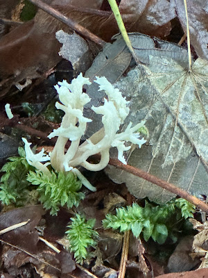
White coral mushroom
Trail surface is dirt and gravel covered in damp decaying fallen leaves
The trail surface is mostly packed dirt with gravel on some parts. Probably the entire trail will have gravel when it is completed. We enjoyed this walk in the woods.
The Heybrook Ridge trailhead parking area is fairly large. There is a public restroom with flush toilets and running water a short distance away in the Index city park and a port-a-potty at the trailhead. The trail winds and twists around until it finally meets up near the paper sign and rejoins the main trail back to the parking area. The sign says the loop is .6 miles RT; however, we added a little by walking as far as the creek crossing to Heybrook Ridge, making it about .8 miles RT. This seemed like not quite enough, so we drove another approximately 15 miles, on a road that had been previously closed but is now open, to the Troublesome Creek camp ground where there is a slightly longer loop trail. There will be a separate post about the Troublesome Creek trail.
Count for the day, .8 miles RT
No people, no dogs
About 50 miles from home


No comments:
Post a Comment