5. Mont-Saint-Michel (Manche) “The Mount Saint-Michel,” France
This is a completely different view of Mount-Saint-Michel
than is normally photographed. The Vintage postcard is
damaged, a corner is missing, but the picture is interesting, so I chose to add
it to my collection. The left edge of
the card is perforated, which suggests that it was originally in a booklet of
several “tear out” cards. Along the upper
left side is the name of the editor: J.
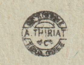
Sorrel. The printer-publisher logo was printed at the center line on the reverse.
Logo found on the center line, reverse side
The famous abbey of Mont-Saint-Michel is located on a tidal island in Normandy,
France. The first monastic establishment
was constructed here during the 8th century. Once the Mont was on dry land but as sea
levels rose, erosion occurred over.
Several outcroppings of granite were left in the bay and produced the tidal island. It was accessible at low tide allowing
pilgrims to cross on dry land. At high
tide those on the island would be stranded.
Modern aerial view
By User:Fabos~commonswiki - Own work, Public Domain,
https://commons.wikimedia.org/w/index.php?curid=604843
During the reign of Louis XI the island was used as a prison. The tides also provided defense during wars as enemies were driven away by incoming water or drowned. As an example, during the 100 years ward an attack by the English in 1433 was repelled by a small garrison. The original tidal causeway was raised in 1879 to help prevent erosion around the mount. Dikes on the coastal flats created pastureland and decreased the distance between the shore and the island.
The new bridge
By Mathias Neveling - Own work, CC BY-SA 4.0,
https://commons.wikimedia.org/w/index.php?curid=34173554
As silt accumulation threatened the island the French government began a project starting in 2006 to build a hydraulic dam, remove the causeway and a visitor car park. Since 2012 a new car park on the mainland has been built about 1.5 miles or 2.5 km from the island. In 2014 a new bridge opened to the public. The new bridge improves the water flow around the island and the efficiency of the dam. Visitors can walk or use shuttles to cross the causeway.
For additional information, see:
https://en.wikipedia.org/wiki/Mont-Saint-Michel
Modern pictures from Wikipedia.


No comments:
Post a Comment