Saturday, October 29, 2016

Gold Creek Trail, 2016


 Trail sign for Gold Creek


Beautiful colors already just at the trailhead parking lot

We have gone on several hikes these past few weeks and I do want to at least cover some of the new places and a couple of the revisited places one at a time.  Although the Gold Creek Trail was not a new one for us, we have hiked and cross-country skied here, this year we hit probably the peak of the Autumn colors hence it seemed especially appropriate to share pictures and notes of this hike first.

To be fair, it has rained this month more than the usual amount.  As of today we are close to breaking a record for October rainfall; therefore, we expected to encounter some mud and perhaps standing water on the trail.  What we did not anticipate was the redirection of some of the small creeks.  The trail literally became a creek in several places.  Fast running water was pouring down the trail even though the day we hiked it was foggy not raining.  Our boots are waterproof so we forged ahead slogging through hoping to achieve the bridge destination at about a 4 mile turn around spot.  Unfortunately we eventually encountered a water pool in the center of the trail that extended on both sides and disappeared in bogs.  No way to go around.  A probe with one of the trekking poles showed that the water was too deep for our boots and would come over the tops.  It was impossible to tell for sure how deep the center part of this pool was and since we had ended up the week before covered in mud to our knees we chose not proceed to the original turn around and backtracked to a drier, rocky place where we could sit, eat lunch and begin the return down.  Very few people that day; we only encountered a work party and three other people actually on the trail.  As we approached the trailhead we met a couple more people and 2 dogs.  The round trip for us ended up approximately 7 miles with about 300 feet of vertical gain.  


 Typical Autumn colors amid the fog


 Lichen in bloom.  I had never seen this before and Bob had only seen it on rare occasions.


 Vine maples


Bob taking photos


 The leaf covered trail


 Amazing and beautiful nature display


Gold Creek, more a river than a creek, as it can be glimpsed from places along the trail 


 These look like snow berries but are not.  We were unsure what they were.


 The small red mushroom (toadstool) above is poisonous.  The small brown and tan ones below grow on rotting logs and can be found in large numbers.


 Queen's Cup berries.  We had never seen these berries before and were surprised at the intense blue color.


 Interesting fungi


Alta Mountain with the first new snow


There were a couple of these areas with tumbled rocks from slides.  Sometimes it was hard to distinguish the trail.


Something new that has been added is a pass under the freeway for wildlife to use.  Projects like this one have been successful in Canada.  There are signs identifying the area.


 It looks like a normal bridge but up closer we could see that the corridor under the bridge is open with a stream and rocks and has been designed to look like a natural area for animals.  Some animals like elk are reluctant to go under so another area will eventually have an overpass for them. 

Thursday, October 27, 2016

If this is Thursday it must be postcards, 270


James Cant Ranch, John Day Fossil Beds National Monument, Oregon

We stopped at the John Day Fossil Beds National Monument in eastern Oregon on the return trip from Utah in August this year.  While we did not stop at the Cant Ranch I did pick up this postcard of the house when we went through the visitor center.  The ranch property extends on both sides of the John Day River in the monument and was originally homesteaded by Floyd Officer in 1890.  It was later sold to James Cant in 1910 who increased the size and built a modern ranch complex on the west bank of the river.  The Cant family sold to the National Park Service in 1975 and the ranch property was incorporated into the National Monument.  The main 2 ½ story wood frame house shown on the card was used as the visitor center until 2003 and is used as the monument headquarters an interpretive center today.  This card was published by Northwest Interpretive Association, printed in the USA and has the identification JODANM-06-NW1A2005. 

Before the arrival of European settlers the John Day River area was used for thousands of years by Native Americans as seasonal hunting and fishing camps.  Gold was discovered in 1862 and a number of small mining towns were established in the area.  The Homestead Act of 1862 encouraged settlement by offering grants of 160 acres to American pioneers so it was not long after the miners that homesteaders arrived.  Most of the ranches of that era produced beef cattle but by 1890 most of the livestock was sheep.  It took Floyd Officer seven years to prove his claim and get his land patent in 1898.
James Cant left Scotland when he was 20 years old and went first to South America where he stayed five years raising horses and mules.  In 1905 he immigrated to the United States arriving in New York City and traveling overland to the John Day country in Oregon where there was a substantial population of Scottish immigrants.  He was hired as a sheepherder and by 1908 he had saved enough money to send to Scotland for his childhood sweetheart, Elizabeth Grant, to join him where they were married in Canyon City, Oregon in October 1908.  He continued to work herding sheep two more years until he saved enough money to buy the Officer ranch.  This very successful ranch became a popular overnight stopping place for people traveling between Dayville and the Columbia River. 

The Cant’s hospitality was well known and they often served meals to twenty or more people including family and ranch hands.  The main house was part of a major expansion by the Cants between 1915 and 1918 when most of the original Officer buildings were replaced.  The house on the card was built in 1917.  The Cant family continued to raise sheep even through the Great Depression then transitioned to cattle in 1946.  Until the completion of Highway 19 in the mid 1920s the ranch was mostly isolated. 

Many of the old buildings are still standing on the property and provide visitors the opportunity of experiencing eastern Oregon’s ranching heritage.  Some of the structures are in poor condition but others, such as the bunkhouse, were renovated and are used to house exhibits.  The chicken coop still has chickens and the shed is used to store feed and ranch equipment.  A small log cabin from when the Officer family lived there is the only remaining building of the original ranch.

Sheep Rock, shown in the postcard below, and named for the sheep that used to dot its slopes, can be seen from the ranch.  The card was published by Discover Your Northwest, printed in the USA and has the identification JODAM-P016-DYNW2013. 


Sheep Rock, John Day Fossil Beds National Monument, Oregon


For more information, see:

https://en.wikipedia.org/wiki/James_Cant_Ranch_Historic_District

Thursday, October 20, 2016

If this is Thursday it must be postcards, 269


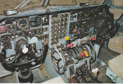
Cockpit instrument panel of the C-123 –K Provider
[photo:  Jim Lawrence, 1989]


We drove to Salt Lake City in August to see Bob’s son and family and on the way we stopped at the Hill Air Force Base Museum near Ogden, Utah.  It was very hot the day we visited and many of the planes were on display outside so I needed to go inside to get out of the heat more often than Bob but we still managed to see almost everything and take a few pictures.  


Small section of the museum interior

The museum is part of the United States Air Force Heritage Program founded in 1981.  The current site of this museum dates from 1991 and has over 90 aircraft from around the world on display as well as other items of historical interest.   The museum has a monster B-52 bomber, guided missiles and a full-sized reproduction of the Wright Brothers first aircraft.  The displays are arranged in five different groups:  the Beginnings of Flight, World War II, Dawn of the Jet Age, The Cold War, and Keeping the Peace.  The museum also has a hands-on Learning Center where visitors of just about any age can try a flight simulator and learn or experiment with a variety of aviation related things such as propulsion methods, gyroscopes, centrifugal force and others.
 

Reproduced Wright Brothers aircraft

The postcard this week was found in the museum gift shop and shows the cockpit of the American military transport aircraft C-123.  A military transport both the U.S. Air Force and the Coast Guard used this plane for search and rescue missions.  It was also used during the Vietnam War to move equipment and men.   It sits low to the ground and had the advantage of being able to take off and land on rough ground and short fields. The plane is huge and has a ramp so vehicles can be driven into it.  It was used to transport President John F. Kennedy’s limousine during the Texas tour in 1963.  The photograph on the card is attributed to Jim Lawrence and dated 1989. 
 

 Each of the planes in the outdoor display had these information placards


 Two views of the C-123


Bob is the airplane enthusiast but once outside and walking around I admit to being impressed with the size of this plane.  The control panel shown on the card was a bonus since we could not go inside the plane.  It was great fun to find the postcard.


For more information, see:


Thursday, October 13, 2016

If this is Thursday it must be postcards, 268


The Fairmont Empress Hotel, Victoria, British Columbia, Canada, ca 1920s

Recently we went to Victoria, B.C., Canada for a couple of days where I found the two postcards shared this week.  The card above has a vintage photograph of The Fairmont Empress Hotel built in 1904 and opened in 1908.  Two wings expanded the hotel in 1909-1914 and more was added in 1928.  Further restorations and modernization were made in the 1960s and 1989.  Originally built as a hotel for the Canadian Pacific’s steamship line it served business people and visitors.  When the Canadian Pacific stopped passenger service to the city the hotel was re-marketed as a resort to tourists.  Victoria became a tourist destination in the 1920s and the postcard photo suggests that it was taken in the late 20s or early 1930s.   Ownership of the hotel has changed hands a couple of times and when the hotel sold in 2014 the new owners, Nat and Flora Bosa invested approximately 30 million dollars in additional renovations. 

The hotel was known as The Empress until Canadian Pacific Hotels changed its name to Fairmont Hotels & Resorts in 1999.  It has 464 rooms, courtyard gardens; most rooms have views of the inner harbor, the Ivy Ballroom, spas, four restaurants and the Lobby Lounge where the world-renowned Tea is served.  We initially thought we would attend the tea, consisting of small sandwiches and desserts, but ended up being hungry at the wrong time and settled one day for ice cream cones on the pier at this little place below and the next day a regular lunch instead of tea in the afternoon.  


However, we did stop in at the hotel gift shop to look around, which netted the postcards and this small teapot.   


The postcard below shows approximately the same view shown as the top card of the hotel as it looks today.  Both cards are published and distributed by The Postcard Factory and printed in Canada.  The top card has a alpha-numeric of PC57-CST 9450 and the second card is identified as PC57-CST 9452.


The Fairmont Empress Hotel, Victoria, British Columbia, Canada, 2016

Francis Rattenbury (1867-1935) was the architect not only for the hotel but also for the Parliament building and several other notable buildings in British Columbia as well as the Burns Manor and Chateau Lake Louise in Alberta, Canada.  He designed the hotel in the Edwardian chateau-style.  


For additional information, see:

https://en.wikipedia.org/wiki/The_Empress_(hotel)
https://en.wikipedia.org/wiki/Francis_Rattenbury

Tuesday, October 11, 2016

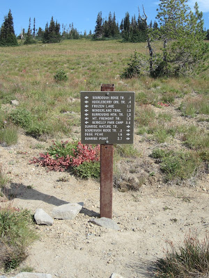
First and Second Burroughs Mountain


Mt. Rainier from a highway view point on the way to Sunrise

Toward the end of August we tried to fit in as many trips to Mount Rainier as possible before the weather turned and the trails closed for the season.   I had been to Frozen Lake and Mt. Fremont Lookout but never on the Burroughs Mountain trail so we decided to try it.  


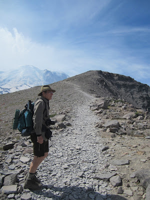
 The trail to Second Burroughs from First Burroughs at the upper left


 Almost to Second Burroughs


 Emmon's Glacier


 Mt. Rainier as seen near where we had our lunch

There are three summits, First, Second and Third Burroughs.  We made the first two summits but the day was waning and we knew it would take us too long to try for the third one so we enjoyed a lunch on Second Burroughs and returned back to the car taking the loop route that gave us different views on the way back.  Usually we count the number of other hikers and dogs we see but this popular park always has too many people to count and dogs are not allowed.  There were perhaps about a dozen people on top of Second Burroughs when this photo above was taken. 


Aster


Blue Bells of Scotland also known as Harebell


Magenta Paintbrush


Smaller mountain Lupine


Tolmie's Saxifrage


Our round trip was 5 ½ miles with a vertical gain of 1200 feet.  Most of the flowers were finished blooming but we did find asters, harebells (Blue Bells of Scotland), saxifrage, some of the smaller lupine and a few Indian paintbrush.   On an earlier hike to Mt. Fremont we had seen goats on the mountainside and this time we saw them in the valley between Mt. Fremont and Burroughs.   We also saw several chipmunks and butterflies.  


 Mt. Fremont Lookout just barely visible from the Burroughs trail


Frozen Lake from Burroughs trail


 Fritillary


 Chipmunk


Mountain Goats

As mentioned previously I am nervous of heights and the back part of the loop or our down path was in places very narrow with a steep drop off.  I don’t know if we had come up that direction and down the other side it would have been easier for me but going down the way we did was a definite challenge.  I tried to avoid looking over the drop off and keep my eyes to the opposite side of the trail but the surface was also quite rocky as well as narrow and as I didn’t want to trip on rocks it was not always possible to avoid looking at the steep down side. 


Looking straight down at the White River and a small pretty nameless lake just long enough to take a picture.


Part of Burroughs is Alpine Tundra with a very different rock and vegetation than lower down where there are trees and other types of plants.  It was a beautiful day with beautiful views! 


 Interesting rock formations


Shadow Lake