Sunday, April 28, 2013

Ballard Centennial Bell


Ballard Centennial Bell Tower

A few days ago we went to visit the “Clover” toy store in Ballard.  It happened that our parking spot was near the small Marvin’s Garden Park at 22nd Avenue NW and Ballard Avenue, which is where the old Ballard City Hall had been located and now is home to the Ballard Centennial Bell.  The bell was cast at the Buckeye Foundry in Cincinnati, Ohio in 1892, is 37.5 inches in diameter and weighs 1,000 pounds or ½ ton.  Originally the bell hung in the Ballard City Hall and rang daily.  It rang to announce fires, quitting time for the local shingle mills, and the curfew for children. 

When Ballard was annexed into the city of Seattle in May of 1907 the bell officially rang for the city of Ballard the last time.  Both the Landaas and Lorig families had ties to Ballard and lived there before it was annexed.  Edd Lorig's machine shop was located very near the city hall.  The former Ballard City Hall was used for a time as a Seattle police precinct station and was eventually demolished in 1965. 
After the demolition of the city hall the bell was moved to the Firlands Sanitarium site and then brought back to Ballard for display at the Hiram M. Chittenden Locks.  A Ballard Bell Centennial Foundation was formed in 1987 to bring the bell and the four white steel columns back to its original site where it now stands.  The bell is powered by an electromagnet and strikes the hours from 9 a.m. to 9 p.m. daily.  On Sundays the bell also rings for a full minute at 10 a.m. and 3 p.m. to mark the opening and closing of the Ballard Farmers Market.


Dedicatory seal
This seal is imbedded in the floor and informational placards are placed on the walls in the bell tower.  One had this drawing below of the old city hall and the original bell tower.  While not exactly as it was the new tower has retained similar architectural lines. 

Drawing of the original Ballard City Hall and bell tower

Closer view of the bell tower


For more information see 
http://www.ballardbell.org
http://www.ballardhistory.org

http://clovertoys.com/pages/about-us


Friday, April 26, 2013

Evolution of an orchid bud


Here is the Lady Slipper orchid plant on the day it was purchased, April 6.


It took nearly three weeks but today it is fully in bloom.  This is a step-by-step view of the bud as it opens. 


The companions on the shelf rejoice . . .


Thursday, April 25, 2013

If this is Thursday it must be postcards, 88


 Sacré Cœur, Paris, France


This unused Yvon postcard shows the basilica of Sacré Cœur in Paris, France.   As the picture beneath it from last year shows we approached it through the streets of Montmartre, came up from the side and did not climb all these stairs, only some of them.  Just the bell tower and part of one dome are visible at the top of the photo but it does show how steep the hillside is.  There is also a funicular rail line that climbs straight up the hill for those who do not wish to use all the steps or go up the steep hillside. 

The title on the reverse of the card is "Le Sacré Cœur de Montmartre et l'escalier monumental"  [the Sacred Heart of Montmartre and the grand staircase].  The card is numbered I.B. 553 and the publisher is identified as "Editions d'Art "YVON" 15, Rue Martel, Paris Fabrication française."  The postcard is one in the Paris -- En Flanant series. 

Posted earlier was a city panorama that included Sacré Cœur from a distance; however, this Yvon photo is so stunning it is getting a postcard Thursday of its very own.  The basilica is located on the highest point in the city and was designed by Paul Abadie.  Construction began in 1875 and was finished in 1914.   The official dedication occurred following the end of World War I in 1919.  The stone is travertine and exudes calcite which keeps the exterior white even with today’s pollution and the stresses of the weather.  Cameras are not allowed inside. 

Here are two links for more information including a short video presentation:

http://www.youtube.com/watch?v=YLs5OIKeO-c
http://en.wikipedia.org/wiki/Sacr%C3%A9-C%C5%93ur,_Paris

Wednesday, April 24, 2013

Chambers Bay


This week’s hike was to Chambers Bay a Pierce County park near Tacoma, Washington.  The park used to be a gravel pit that produced 250 million tons of gravel during the years it was operating.  Today the land is being reclaimed and developed as a park with an adjacent golf course.  The western side runs along the water and the majority of the group chose to do a beach walk instead of the approximately 3.5 mile loop route around the park that climbed up about 300 feet and afforded lovely views of the water and the golf course then wound around through some woods and back to the starting point near the parking lots.  It was a beautiful day with lots of sun but not too hot so walking up hill was comfortable.  We did the loop and then went down to the beach for lunch. 


 A little brown rabbit was munching his way through the flowering Miner’s Lettuce and paused just long enough for a couple of pictures.  We saw lots of flowering weeds and a few native plants in bloom also.  We were lucky enough to walk with someone well versed in native plants and weeds adding a few more plants by sight but it will be a while before I have memorized all the names.  It is still early in the season for flowers more things will be blooming in the coming weeks.   Apologies in advance if some of the plants are not named as they should be, corrections are welcome.

Madrona blossoms


Mustard


Elderberry


Oregon grape, low growing variety


Vetch


Geranium family

Red Dead Nettle


Miner’s Lettuce and Candy Stripe
 Chambers Bay, also called Chambers Creek, is a very large pretty park with a visitor’s center and nice rest rooms not just port-a-potties.  Along one area of the park are the remains of buildings from the gravel works that stand up huge and look like something from a movie set or Stonehenge re-visited.  There is also a large playground for children complete with a castle.  
Children's play area

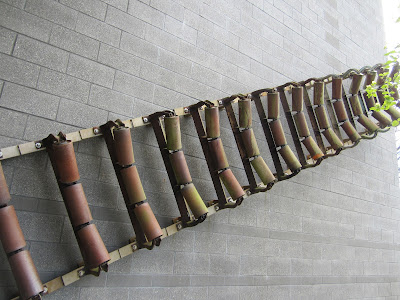
The property has seen several uses since 1830 when the settlers first arrived.  Besides the gravel pit it was also developed as farm land for a short period of time but that did not prove successful and it reverted back to a gravel mine.  Judge Thomas Chambers owned a large part of the land which he donated in the 1850s.   A roller conveyor is mounted on the wall of the vistor’s center.  This was used to move the gravel bins from the mine to the transport trucks.   It looked more like a modern sculpture instead of primitive machinery.


Conveyor for gravel


Views from the loop trail . . .


Thursday, April 18, 2013

If this is Thursday it must be postcards, 87


La Cour des Voraces, Lyon, France


A friend who lives in France recently took a trip to Lyon and sent this postcard to me.  At first glance I thought the stair complex in the photo was a modern structure because the card is not a vintage postcard but a recent one.  Along with the card my friend had included a few notes so I quickly discovered that the stairway was much older than I thought.  The picture is of the Cour des Voraces located on La Croix-Rousse hill, was built in 1840 and is a traboule.   It is the oldest concrete construction in Lyon.  Traboules are a type of passageway found in a few French cities but mostly associated with Lyon.  The earliest ones were built in the 4th century and were used originally to allow workers to go from their homes to the river to get water quickly and to move goods from their workshops to the merchants at the foot of the hill.  

Lyon is historically known for its silk industry.  It is built on hills and has very few connecting streets running perpendicular to the river so the traboules provided a way to transport goods such as clothes and other textiles through the city while giving shelter from the weather.   Conditions for the silk workers were deplorable and they revolted in 1848 and 1849.   Some of the traboules served as refuges for them at those times.  During WWII the traboules were little known to foreigners and were used by the resistance during the German occupation as places to escape from surveillance while engaged in covert activities.  Today some of them have been closed, blocked off, and/or used as storage areas while others are tourist attractions with over 40 of them open to the public. 

The black & white postcard is numbered LOM 051 and was published by editions Laurentreiz. 

The court shown on the card is classified as an historic monument. 

For more information see: 

http://en.wikipedia.org/wiki/Cour_des_Voraces
http://en.wikipedia.org/wiki/Traboule
http://en.wikipedia.org/wiki/Croix-Rousse


Card published by www.editionslaurentreiz.com LOM 051

As always, thank you to my French friend for thinking of me and for sharing this postcard. 

Wednesday, April 17, 2013

New boots go hiking


New boots
Finally new hiking boots.  The new boots were worn around the house and outside a little since purchasing them and no sore spots.  Extra waterproofing went on them and then Tuesday I went with a group of people to try them out on a real outdoor trail. 

The destination was Cedar Butte.  This is near the Cedar River/Cedar Falls watershed.  It is in the Olallie State Park not far from North Bend, Washington and is about a 5 mile round trip hike with an elevation gain of 900 feet. 


We did see Salmon Berry blossoms, the buds on a very few Oregon Grape plants, one tiny little yellow stream violet, several Trilliums, Indian Plum, lots of lacy moss both on the ground and growing on the trees.  Not yet blooming but recognizable from their tiny new leaves were Wild Rose, Bleeding Heart, low growing blackberries and Huckleberries. 


Lacy moss growing on a branch


Bob standing by a moss covered Vine Maple tree


Another view of the Vine Maple covered in moss


Trilliums

Most of the Trilliums were so sodden from the rain that they were drooping and needed some assistance in order for me to take a photo.  Usually they seem to grow more or less separately but there were several plants clustering together in little patches along the trail. 


Conks

These are very small “conks” a fungus that grows on trees.  They sometimes grow to be quite large on old stumps and big trees.


Rattlesnake Lake from a distance

Near the summit there is a place that has a view of Rattlesnake Lake.  The water was a beautiful blue green color.


Zooming in on Rattlesnake Lake

There was a small bench and a benchmark at the summit.   Bopa was always looking for benchmarks so it was fun to find this at the top.


Benchmark

This was a “step” above in difficulty from the Twin Falls hike a couple of weeks ago.  It starts out flat along the John Wayne Trail, an old railroad bed, and then moves into the forest becoming narrow and steep at times.  The last portion is quite steep and I did have to stop and catch my breath a couple of times before proceeding upward.  There were not as many wildflowers on this hike as it is still early in the season and this trail, at almost 2,000 feet elevation, was slightly higher and colder than the one at Twin Falls.  Most of the group reached the summit and had started back down as we were still going up.  It had snowed a bit at the top and was raining lower down.  I kept stopping to take photographs and to rest.  This was Bob’s first real trip out since his foot surgery and he needed to go slow which I appreciated very much because it meant I was not all alone at the tail end of the group.    Next week’s hike is supposed to be a little easier.


Views from Cedar Butte summit