Saturday, May 27, 2017

Suiattle River 2017


Suiattle Trail

One of Bob’s friends had hiked this trail recently and commented on the number of Calypso orchids.  Since these are among our favorite flowers to find in the wilderness we decided to go check them out.  


Once again we found members of the WTA hard at work repairing and improving the trail.  There were a few downed trees to climb over or under and one place where the crew was rebuilding a bridge so we had to wade through water.  On the return trip we were the first people to cross the new bridge. 


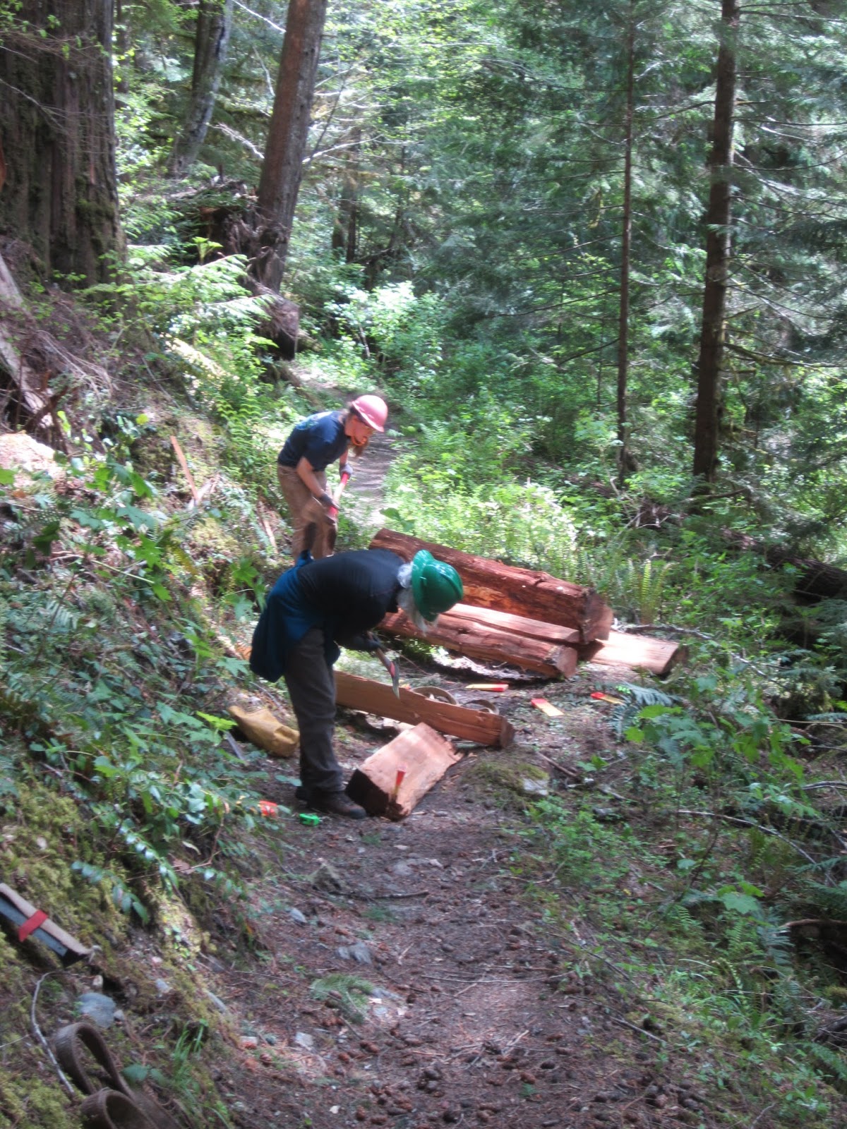
 Two women splitting a downed cedar log to use in the stairs pictured below


Yes, we did find lots of the little orchids as well as trillium, fairy bells, bleeding heart, miner’s lettuce, Elderberry, yellow stream violets, wild ginger, and one morel mushroom plus one fake poisonous morel. 


 Fairy bells


Calypso orchid


 Yellow stream violet


 Trillium


 Bleeding heart


Elderberry with friends (butterfly and bug)


 Pink miner's lettuce


 Morel mushroom


 Fake Morel (poisonous)


Suiattle River

The river was high and running fast, we did not do a toe test but can guess that the water must have been extremely cold too.  Aside from the work crew the only other people we saw were a mother and her two boys and their dog who were planning on camping overnight.  There is a nice stopping place 3 miles in near the river where we had lunch and they arrived just as we were about finished.  The mother said it was the first time the boys had carried heavy packs and she thought they were pretty tired so since we were leaving they decided to camp there.  Our round trip was 6.4 miles with a 500 ft elevation gain. 


Friday, May 26, 2017

Deception Pass, two short hikes, 2017


In addition to the regular signage this park has a map showing the entire area


Each time we have gone to Deception Pass to hike we have found wonderful flowers.  This time was no exception.  From a previous hike we knew there would be chocolate lilies in one certain location and if we timed it right we would find them in bloom.  Also the blue camas and white death camas bloom at approximately the same time as the lilies so we felt certain we would find them also.  Yes!   We went up to Goose Rock first and then drove to Rosario and walked a short loop near the Indian Maiden statue. 


The Goose Rock loop is steep either way.  We take the summit trail up to the top and the twisting, switchback perimeter trail that has views out to the water on the return.  Many folks prefer to do the perimeter route up and the summit trail down but it doesn't really matter.  Big hits besides the flowers were 9 eagles flying overhead and calling to one another and two little bunnies munching grass near the Indian Maiden statue at Rosario.


 View from Goose Rock looking toward the Whidbey Island Naval Base


Field Chickweed


 Death Camas -- looks a little like a miniature Bear Grass


 Both kinds of Camas growing in the field


 Camas


 Naked Broomrake


Chocolate Lilies  --  We saw dozens of these, more than we have ever found before


 Rhododendron


 Larkspur


 Indian Paintbrush


 Sedum


 Sea Blush


 Indian Maiden Statute at Rosario


 Warning is because there is no fence on the cliff edge


 Camus


In the morning at Goose Rock we saw 8 hikers and one dog.  In the afternoon at Rosario we saw 10 people and 4 dogs. This cute little pooch was friendly, well behaved and even posed for a photo while we visited with his owner who was taking photos of flowers as we were also doing.


 Madrona trees


 Bob taking photos


 Prostate Lupine and Vetch


 As we came down we saw people fishing from the dock


and kayaks going out into the bay

Thursday, May 25, 2017

If this is Thursday it must be postcards, 300


 Black Horse Pub, Pluckley, Kent, England

This postcard with a charming watercolor picture of the Black Horse Pub in Pluckley, Kent, England, recently arrived in the mailbox.  Friends who had taken a trip to Paris and then made a day trip via the Chunnel to gather some family history information in Pluckley sent it.   England Pictures produced the card and the artist is identified as Dian Setek.  Mrs. Setek is well known for her pen & ink and watercolor paintings of English countryside, cities, towns, scenes and historic buildings. 

Situated approximately 5 miles or 8 km west of Ashford, Pluckley is located on the edge of a well-drained plain.  Pluckley is a village with a population of around 1,000 individuals.  It is said to have at least 15 ghosts and is labeled “Britain’s most haunted village.” It is also mentioned as a top destination for paranormal investigators.  These supernatural events include a wide range including noises like those heard in the Screaming Woods; apparitions, such as re-enactments of a deadly battle, a gypsy lady who accidently burned to death, a horse and coach, various suicide victims, and figures roaming some of the buildings, women who lost children wandering in the graveyard looking for their babies; and missing items.

Black Horse Pub is said to harbor a poltergeist that pilfers items, usually clothing and then returns the items several days later but will sometimes also move glasses and dishes around the pub.  Many customers have also mentioned seeing or feeling the ghostly presence of a small child.  Originally built in the 1470s, it was farmhouse belonging to a prominent local family, the Derings.  It has a surrounding dry moat.  When the Dering family sold the estate in 1928 many former tenants were able to buy their own homes.  Today it is an inn and public house.  It is advertised as dog friendly with rambling (hiking or walking), cycling, coach tours as well as welcoming paranormal investigation groups. 

Trivia:  An old Roman villa was discovered nearby at Little Chart.  The existence of Pluckley as a clearing or small village has been known as early as the time of the survey or census called the Domesday Book completed in 1086.  At that time there were 16 villagers, 7 smallholders, and 8 slaves for the 12.5 acres of land and caring for 140 pigs.  It was considered a thriving community.  The Black Death or plague in the 14th century decimated the population.  Survivors retreated to higher ground believing that the lowland was unhealthy.  The Dering family grew in importance during the reign of Henry II.  The first baronet is famous for creating a huge library of books, maps, charters and manuscripts.  Among the collection is a manuscript text of the Shakespearean play, Henry IV.  Scholars think the Dering manuscript copy represents a version prepared around 1613 perhaps for family or amateur theater.

The stamp is an orange, Queen Elizabeth II, profile.


As always with many thanks to friends for sending the card.

For more information, see:


https://pluckley.net/village-life-history/
https://www.blackhorsepluckley.co.uk/
https://en.wikipedia.org/wiki/Pluckley
https://www.thesun.co.uk/archives/news/68980/britains-most-haunted-village
https://en.wikipedia.org/wiki/Domesday_Book

Thursday, May 18, 2017

If this is Thursday it must be postcards, 299


 Popocatépetl and Iztaccihuatl, Mexico, ca 1950s


Today’s postcard is one that was among the large group of travel cards that I got from friends about a year or so ago.  The picture is of two large volcanoes in the eastern half of the Trans-Mexican volcanic belt in the states of Puebla and Morelos, Central Mexico.  The photograph is credited to J. Kipi Turok.  The unused card was published by Ammex Asociados, S.A. and printed in Mexico.  Because most of the cards in the lot date around the 1950s and 1960s, it is likely that this card is from that era. 

The mountain at the upper left is called Iztaccihuatl (can be spelled without or with accent marks), the White Woman in English, or sometimes Mujer Dormida, Sleeping Woman.  In the foreground at the right is the companion volcano, named Popcatépetl translated as the Smoking Mountain.

Popcatépetl, located about 43 miles or 70 km southeast of Mexico City, is an active volcano that has erupted more than 15 times since the Spanish arrived in 1519.  The peak at 17,802 ft or 5,426 m high is the 2nd highest major peak in Mexico.    Since 1993 smoke has been constantly seen coming from the crater.  As recently as a 2016 the mountain was spewing lava, rock and ash.  Early 16th century monasteries founded by the Spanish are located on the slopes of the mountain and are now listed as a World Heritage site. 

Iztaccihuatl, also a volcano, is dormant.  Scientists think that this volcano last erupted about 11 thousand years ago.  It is 17,160 ft or 5,230 m tall and is listed as the 3rd highest mountain in Mexico.  Although the Aztecs or other earlier people may have climbed the mountain, the first modern recorded ascent was in 1889.  Snow and glaciers are permanent year round features. 

There are several legends or myths about these two mountains. One Aztec myth tells about Iztaccihuatl, a princess, who fell in love with one of her father’s warriors, Popcatépetl.  Her father, the emperor, sent Popcatépetl to war in Oaxaca and promised him his daughter’s hand in marriage when he returned.  Iztaccihuatl was falsely told that her lover had been killed in battle whereupon she died of grief.  When he returned and discovered that she had died, Popcatépetl took her body to a spot outside Tenochititlan.  Some say he did this in the hope that the cold would wake her but instead he froze to death.  The gods covered them both with snow and changed them into mountains.  Iztaccihuatl’s mountain is called White Woman because it resembles a woman lying on her back.  Popcatépetl’s rage at losing his love is shown by the volcano raining fire on the Earth.  There are various versions of this particular story and also other similar but slightly different tales about these two mountains. 


Many thanks to friends who share postcards.

For additional information, see:

https://en.wikipedia.org/wiki/Popocat%C3%A9petl
https://en.wikipedia.org/wiki/Iztaccihuatl
https://en.wikipedia.org/wiki/Popocatepetl_and_Iztaccihuatl
https://en.wikipedia.org/wiki/Ring_of_Fire


Thursday, May 11, 2017

If this is Thursday it must be postcards, 298


Sinclairsholm, Skåne, Sweden, ca 1908

A side trip to a local antique mall netted this Axel Eliasson vintage postcard showing the front of Sinclairsholm Castle in southern Sweden.   The card is unused and has the number 4142 on the reverse in the lower left corner.  It was printed in Germany and distributed in the United States by the Swedish Importing Company of Worcester, Massachusetts.  All early color postcards were hand tinted or painted before mass printing.  

The original castle was constructed mainly of wood and completed in 1626.  There are been at least two major fires that resulted in changes to the outward appearance of the castle.  Today the main portion of the building dates from 1788.  One of the things that makes this particular card historically interesting is that the building has the French Chateau style mansard roof, designed by Mauritzberg From, that was the result of a major renovation completed in 1880.  There was another fire in 1904.  In 1956 a second major renovation and restoration project replaced the French Chateau style and restored the building to its original 1788 design, seen below in a Google Image.  It has a completely different look making the Chateau style a sort of historical oddity of less than 100 years.


Sinclairsholm, Skåne, Sweden, as it appears today
[photo:  Google Images and
]

Anders Sinclair or Sincklar (1555-1625), A Scottish nobleman, was a Danish privy counselor in the late 1500s to the early 1600s under the Danish king Christian IV.  He was also an envoy to England, a military colonel and the governor of Kalmar, Sweden following the Danish capture the city.  He  was also the holder of extensive fiefs in Denmark.  After he married Kirsten Kaas in 1600 he left the court and established this estate named for him.  Construction appears to have been begun around 1620 but not completed until 1626 a year following Sinclair’s death.   His son, Christian Sinclair (1607-1645) took over the ownership.  It was later purchased first by Jochum Beck with ownership changing hands a couple of times until 1808 when it was acquired by the family Gyllenkrook who have passed it forward in the family.  Through marriage it is now the estate of the family Barnekow and owned by Johan Barnekow. 

My family members may find it fun and interesting to note that among all the properties that he held, Anders Sinclair at one time exchanged one of his fiefdoms for Hammerhus on the Danish island of Bornholm since that island is where my paternal grandfather was born and lived until he came to America in the 1890s.  In 1982 we visited Bornholm and walked around the ruins of Hammerhus.  


Part of the Hammerhus, Bornholm ruins, Denmark, 1982


It is always fun to find some connection to places, events and people.   Postcards offer peeks into the past that often result in unexpected surprises. 

For additional information, see:

https://en.wikipedia.org/wiki/Sk%C3%A5ne_County
https://en.wikipedia.org/wiki/Sinclairsholm_Castle
https://en.wikipedia.org/wiki/H%C3%A4ssleholm_Municipality
https://en.wikipedia.org/wiki/Andrew_Sinclair_(privy_counsellor)
https://en.wikipedia.org/wiki/Scania
https://translate.google.com/translate?hl=en&sl=sv&u=https://sv.wikipedia.org/wiki/Sinclairsholms_slott&prev=search

Friday, May 5, 2017

Middle Fork Snoqualmie 2017, prequel


Since our October 2016 hike to Middle Fork Snoqualmie was mentioned in the Middle Fork Snoqualmie, 2017 post, but it did not get separate billing at the time, I thought perhaps an explanation might be helpful. 

The October hike was one of the later hikes of the season and the trail was extremely muddy.  WTA crews were hard at work improving and making repairs to the trail.  Part of the large parking area at the trailhead was being used as the pad for a helicopter and there were stacks of supplies ready to transport to selected sites along the trail.  We encountered several stacks of wood as well as gravel piles.  


Three members of the WTA crew and a nice new bridge over a creek. 

One usually expects the forest trails to be quiet and peaceful with bird song and soft sounds of rushing river water or breezes through the trees but on that day the noise and wind from the chopper was all we could hear.   It was fascinating to see how the pilot could thread the load down through the large trees, 150 to 200 feet tall, to a small spot on the trail.  The waiting WTA crew ready to grab the cable and unhook the load once it was safely down.  


 That day we saw mostly mushrooms and mud. 


 Bright red berries


 Mushrooms growing near logs, on logs, and in the wet ground everywhere


Unusual deep purple blue mushroom


 Lots of squishy, wet mud everywhere . . .