Thursday, October 31, 2024

If this is Thursday it must be postcards, 683


Happy Halloween


These three cards shared this week and are numbered H14, H15, and A16.  They all have examples of symbols used at Halloween. They are unused Halloween postcards printed by Laughing Elephant.com and are reproductions of a vintage illustrations from around 1910.  The card above has the code:  H 16 with an N inside a triangle and a copyright symbol at the lower left side.  The illustrator is not identified but the style dates all three the cards to the early 1900s when greeting cards for all or most holidays were popular.


This second card has the code:  H 15


And the third card has the code:  H 14


Halloween is also known as All Hallows’ Eve and All Saints Eve.  It is celebrated across the globe and observed in many countries, including the United States, on 31 October.  Many Halloween traditions appear to have been influenced by Celtic harvest festivals such as the Gaelic Samhain.  While some believe it stems from pagan roots many others think it might stem from an early Christian holiday called All Hallows’ Day when a vigil was kept in remembrance of the deceased.  Modern day Halloween activities include things like trick-or-treating, parties with apple bobbing, carving pumpkins to make Jack-o-Lanterns, divination and other games, dressing up in costumes, playing pranks, visiting “haunted houses,” or watching scary movies.  


 Jack-o-Lanterns were used as a symbol on All Hallows’ Eve long ago in Ireland.  Since there were no pumpkins in Ireland at the time this tradition began, turnips were used instead.  An old Irish folk tale has a man named Stingy Jack who made both God and the Devil angry, and was therefore not welcome in either heaven or hell because of it.  He was forced to roam the earth with only the turnip jack-o-lantern to light his way.   People would put Jack-o-Lanterns around their homes to keep Stingy Jack from coming to their house on the night that the vigil was kept for the dead.  


"Wise women" who in earlier times were known to be helpful with healing illnesses, were feared under Christianity, becoming known as "witches," and considered as symbols of evil and sorcery.   Bats were associated with the myth of vampires.  They were considered spooky because they might transform into a vampire and suck the blood of animals and humans. 


Druids believed that evil humans could turn themselves into cats.  Black cats were especially vulnerable since the color black was a symbol of evil and death.  Owls were also thought to be associated with witches and therefore evil.  The sharp call of a Screech Owl made people think of witches flying overhead. 


Ordinary playing cards are symbolic of various things too.  Red for warmth and light, black for cold and the powers of darkness.  The four suits:  the spade is in the shape of a leaf; the heart becomes the center of life; the diamond, represents the feminine, and the club the masculine. 


Cards are also representations of luck, good or bad as in “the hand that fate dealt.”  The 52 cards in a deck equal the 52 weeks in a year; the 13 cards in each suit equal the lunar months in a year.  All kinds of playing cards, and special divining cards, like Tarot cards, were also used for telling fortunes. 


Brooms were thought to be able to sweep away the evil.  It is not clear why witches use brooms to fly around; however, it may stem from pagan times when rural farmers would dance around astride pitchforks and brooms during a full moon to encourage the growth of their crops.


For additional information, see:


https://en.wikipedia.org.wiki/Halloween

https://www.history.com/news/why-witches-fly-on-brooms

https://kinghalloween.com/halloween-symbols/

https://safepaw.com/from-bats-to-black-cats-the-real-stories-behind-halloweens-furry-icons/

https://www.edmonton.ca/city_government/edmonton_archives/halloween-icons#:~:text=Some%20believe%20owls%20and%20bats,Dracula%20was%20published%20in%201897.

https://public.websites.umich.edu/~umfandsf/symbolismproject/symbolism.html/C/cards.html


Tuesday, October 29, 2024

Split Rock, Teanaway Community Forest, 2024


 Split Rock


Last year we heard about some interesting rock formations in the Teanaway Community Forest and took a hike to Cheese Rock.  See the Cheese Rock blog post from 1 October 2023.  As you can see from the photo below, Cheese Rock lives up to its name and looks like a piece of Swiss cheese.  


Cheese Rock, Teanaway, 2023


But there are more of these monolithic sandstone rocks, lots more as it turns out.  After watching a couple of YouTube videos showing some of the various trails and rocks, we chose to see if we could find Split Rock which is somewhat close to Cheese Rock.  The Teanaway Community Forest is located in Eastern Washington not far from Cle Elum.  It is a new area opened for hikers, non-motorized bikes, and horses.  The parking area is being enlarged, more trails are being added, and there is a nice, newer, clean outhouse.  Because it is just being developed there are no signs or even maps with trails marked.  Bob made his own map by combining a Green Trails map and another forest map.  He added some marks to point the way to Split Rock from information gleaned from Washington Trail Association (WTA) trip reports. 


Vesper Rock slab

Another interesting rock formation is called Vesper Rock.  It is one of ways to arrive at Cheese Rock, the other way is via an old logging road.  Vesper Rock, is a sandstone slab about ½ mile long straight up, that looked steep and possibly hazardous for us.  It is not a climb but more like a scramble.  It would be a double black diamond ski route.   


The route to Split Rock breaks off from the same logging road to the right before it branches off toward Cheese Rock.  We started out on the old logging road looking for a 4-way junction that was supposed to have a narrow path on the right side, heading up to Split Rock.  We found it!


Old logging road


 Path up to Split Rock


Turning off the logging road at the 4-way junction is this narrow path, about ¼ mile long, up to Split Rock.  We later found out from a couple of mountain bikers that that path continues back to the bridge near the parking area essentially making it a loop trail.  We returned the way we had come up but if we do this again, we will try the loop instead.


Western Larch trees now golden


 The Larches were in fall splendor, standing brilliant gold in among the evergreens


This is a mixed forest area with lots of Ponderosa Pines, Western Larches, Firs, and some deciduous trees most of which had already lost leaves.  In the spring and summer Larches look like bright green evergreen trees.  Unlike evergreens they turn golden in the fall and lose their needles. 


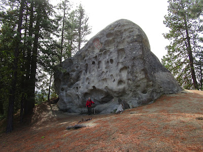
Bob posing in Split Rock


Split rock is enormous, Bob estimated it to be approximately a 20 x 20-foot cube, weighing 600 tons.  It has more than one fissure with bubbles, lumps and bumps.  There is even a balancing rock on one side.  Some of the shapes looked like faces to us.  There is a path that goes all around the rock. 


 Balancing rock


Do you see a man wearing a hat on this side of Split Rock?


Or a child's profile on this rock?


A separate fissure on the side of the rock has a peek hole


Count for the day:


2 mountain bikers, 2 dogs

5 miles RT, 500 ft elevation gain

102 miles from home


Thursday, October 24, 2024

If this is Thursday it must be postcards, 682


Solvang, California, “Danish Days Fete,” ca 1962-1966

[photo by Ray Foster]


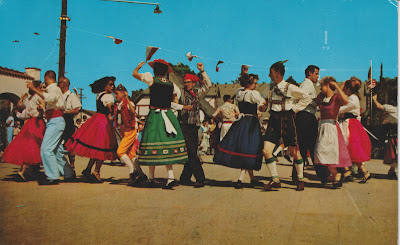
A colorful photograph by Ray Foster shows folk dancers during the Danish Days Fete in Solvang, California on this unused postcard.  The card was sold with a stamp affixed.  Since the gray 5-cent George Washington stamp was issued and used between 1962 and 1966 the card can be dated to those years.


1962-1966 George Washington Stamp


The card was distributed by Bob Ball, of Visalia, California and has color by Mike Roberts of Berkeley, California.  The identification code, C7481 appears at the lower left corner on the reverse.  A blurb is found at the upper left corner on the reverse:  “Solvang, California  One of the many folk dances in which one may participate during the Danish Days Fete, usually held the first weekend in August.” 


Solvang is a small community in Santa Barbara County California.  Its name is Danish for “sunny field.”  Originally settled in 1804 when a Spanish mission, Santa Inés, was founded here during the Mexican period.  The community was mostly abandoned by 1910-1911 when a group of Danish Americans purchased 9,000 acres of the surrounding area that would be far away from the harsh winters of the Midwest.  By 1912 when it was becoming difficult to sell more lots in the town the developers traveled to Iowa and Nebraska to encourage new Danish immigrants to buy land in Solvang.  The early settlement had a bank, a store, a lumber yard, a barbershop, and a post office.  Restaurants have also become part of the modern revitalization.  The buildings have Danish-themed architecture.  In the beginning it was mainly an agricultural area; however, today It is now mostly a tourist destination featuring Danish heritage.  


The postcard shows folk dancers in brightly colored and varied Danish national folk costumes called “folkedragter.”  Like Norway and Sweden, it is possible to tell where the person comes from by the design of the folk costume.  The card shows representatives from several different parts of Denmark. 


For additional information, see:


https://en.wikipedia.org/wiki/Solvang,_California

https://denmark.net/folkedragter-many-styles-denmarks-national-costume/


Thursday, October 17, 2024

If this is Thursday it must be postcards, 681


Malmesbury, Wiltshire, England, ca 1902-1905


The used divided back postcard shared this week, is a souvenir type card with six views of landmarks in the town of Malmesbury, Wiltshire, England.  At the left margin on the reverse the card it is identified as “The ‘Famous’ series, Tomkins & Barrett, Swindon.On the front of the card each landmark is separately identified at the bottom of the picture.  The top row, from the left:  exterior view of the Abbey, Market Cross, and an interior view of the Abbey.  Bottom row, from the left:  Cowbridge House, Charlton Church, and High Street.  If one looks carefully, a very faint X can be on the High Street photo at the lower right.  At the upper right corner is a place for a Halfpenny stamp.  Halfpenny stamps were used between 1870 and 1906, suggesting that this card dates from 1902 when divided backs were introduced in England to 1906.


Multi-view cards as souvenirs have been printed as early as the 1880s and are still popular today.  This card is addressed to Mr. & Mrs. Jacques Matenge and has a handwritten note on the back of the card that reads:  “Ingram House, Malmesbury.  The Mayor and Mayoress (Mr. & Mrs. Adyed) wish you the compliments of the season & hope you are all quite well & happy.  You will recognize the views, our house marked X.  Best wishes.” 


Malmesbury is a town and civil parish in north Wiltshire, England.  The older part of the town is on a hilltop that had once been the site of an Iron Age fort.  There are several freshwater springs on the hilltop that helped the early settlers.  The Abbey was originally founded in 675 by an Irishman named Maildubh.  The town takes its name from a combination of Maildubh and burh or Maildubh’s fortification which later morphed into Malmesbury.  During medieval times the Abbey became well known as a place of learning. 


Some trivia facts of interest, in 1010 there was an early attempt at human flight when a monk, Eilmer of Malmesbury, flew a primitive hang glider from the tower.  He flew over 180 meters or about 590 feet before (crash) landing and breaking both of his legs.  By 1066 when a census, called the Domesday Book, was taken Malmesbury is listed as the first, or most important town, in Wiltshire.  The wooden town walls were replaced by stone walls during the 1100s. 


Today Malmesbury is best known for its abbey.  The economy is mostly agriculturally based but also depends on tourism. 


For additional information, see:


https://en.wikipedia.org/wiki/Malmesbury

https://en.wikipedia.org/wiki/Malmesbury_Abbey

https://worldpostcardday.com/history


Thursday, October 10, 2024

If this is Thursday it must be postcard, 680


House of Giulio Romano, Mantua, Lombardy, Italy

[painting by Ettore Roesler Franz]


The unused postcard, featuring a painting of the house of Giulio Romano (c. 1499-1546), is identified as a product of Casa Bestettie e Tumminelli, Milano-Roma along the left margin on the reverse.  At the top center on the reverse is “Roma Sparita, Acquarelli di F. Roesler.”  At the bottom of the center line on the reverse is E.V.R., Serie II – N. 34.  At the lower left is “Casa di Giulio Romano. 


The watercolor painting is by the Italian painter and photographer, (Ettore) Roesler Franz (1848-1915).  It was part of a series consisting of 120 pictures titled “Roma Sparita” or Vanished Rome, that featured watercolor paintings depicting parts of Rome that were in danger of disappearing.  Today many of these places have vanished or changed making the pictures a valuable historical record.  The paintings were completed between 1878 and 1896.   In 1875 Franz along with Nazzareno Cipriani developed a plan and created what became the Association of Watercolorists and included 8 other artists as founding members.  Among his clients were the Empress Maria Feodorovna, Kings Victor Emmanuel II and Umbert I, and Louis IV, Grand Duke of Hesse. 


Giulio Romano was born around 1499 and died in 1546.  He was an Italian painter and architect.  He started out as one of Raphael’s assistants, and became an important member of Raphael’s studio.  His drawings are said to be a significant contribution to the spread of 16th century Italian style art and are treasured by collectors.  However, it is his architectural work that has had more influence.  He designed his own house in 1540 and completed it in 1541-42.  The exterior of the original building was described as having a fantastic façade all worked in colorful stucco.  At the time of the Franz painting on the card in the late 1800s the building had already been remodeled and expanded from six bays to 8 and would have been quite different than it was in the 1500s.  The central hall with its original fireplace and frescoes have been preserved.  The ground floor has shops with the main floor contains what was Romano’s home. 


For additional information, see:


https://it.wikipedia.org/wiki/Casa_di_Giulio_Romano

[Note: there is a translation option]

https://en.wikipedia.org/wiki/Giulio_Romano

https://en.wikipedia.org/wiki/Ettore_Roesler_Franz


Thursday, October 3, 2024

If this is Thursday it must be postcards, 679


Alpi Giulie – Julian Alps, Italy and Solvenia


Recently I received the postcard shared this week from my friend who lives in Italy.  He had returned from a week-long trekking (hiking) trip in this region and picked up the card to show me what the mountains look like.  On the reverse of the card, at the upper left and in Italian, is: “Friuli Venezia Giulia, Italy.  Alpi Giulie – Julische Alpe.  Gruppo del Canin, Val Rio del Lago e Gruppo Montasio.”  The card is an edizioni CARTOLNOVA with the number 2267 at the bottom left margin on the reverse.


The Julian Alps are named after Julius Caesar and are a mountain range that stretches from northeastern Italy to Solvenia.  The Western Julian Alps include the Canin Group which is partly located in Solvenia and the Montasio Group found in Italy.  The three highest peaks are:  Jôf di Montasio at 2,755 meters or 9,039 feet high; Jôf di Fuart at 2,666 meters or 8.747 feet high; and,  High Mount Kanin (Canin) is 2,582 meters or 8,471 feet high. 


Jôf di Montasio is located in the Province of Udine, in the Friuli-Venezia Giulia region of northeastern Italy.  This would not be too far away from where my friend lives.  On the back of the card he in part wrote:  “… spent a week … in a valley in Friuli, north Tarcento.  The landscapes were beautiful… Mainly woods and very steep slopes but wonderful views on the surrounding peaks and valleys…this is the most rainy of the whole of Italy and it was indeed very green.  We saw many beautiful flowers and even some chamois!...A gondola lift took us on top of this historical mount offering jaw-dropping views…”


Chamois are not found in the U.S., the closest look-alike might be a prong horn antelope.


 Chamois


By Giles Laurent - Own work, CC BY-SA 4.0, https://commons.wikimedia.org/w/index.php?curid=121240048


 Prong Horn Antelope


By Yathin S Krishnappa - Own work, CC BY-SA 3.0, https://commons.wikimedia.org/w/index.php?curid=24551366


As always, thank you to M. for sharing the card.


For additional information, see:


https://en.wikipedia.org/wiki/Julian_Alps

https://en.wikipedia.org/Friuli-Venezia_Giulia

https://en.wikipedia.org/wiki/Chamois