Thursday, August 29, 2024

If this is Thursday it must be postcards, 674


Lisbon, Portugal, ca 2018


An unused oversized panorama tourist postcard with the number 177 at the upper left on the reverse, this card is a www.revelamos.com product.  A blurb in three languages, Portuguese, English, and Spanish, is found along the bottom edge on the reverse.  The English translation:  “With a personality of all its own, Lisbon is a capital city that can boast over 800 years of history and a wide range of cultural influences that happily mingle with the most avant-garde trends.  An amalgam of styles and an assortment of contrasts give it a special charisma reinforced by the waters of the Tagus.”


This is one of several cards shared by my son and daughter-in-law from a trip they took to Portugal and Spain in 2018.  It shows the city of Lisbon’s harbor on the Tagus River.  Lisbon’s port on the Tagus is the country’s third largest port.  It is a natural harbor that opens to the Atlantic Ocean.  The five most recognizable architectural landmarks of the city are identified with brief information.


Five landmarks in Lisbon marked


1.      São Jorge Castle (Saint George’s Castle).  There were earlier fortifications on this hilltop by Phoenicians, Carthaginians, Romans and Moors before the Portuguese conquest in the Siege of Lisbon, 1147.  It has served as a royal palace, a military barracks, home of the Torre do Tombo National Archive, and now as a national monument and museum.  Archaeologists have found human presence in the Tagus valley from the 8th century BC.  In about 48 BC Lisbon was a Roman city with a fortification here.

2.     The Church and Monastery of St. Vincent.  Founded in 1147 the original Monastery of St. Vincent was built by the first Portuguese King, Afonso Henriques.  It was named for the patron saint of Lisbon, Saint Vincent of Saragossa whose relics were brought to Lisbon in the 12th century.  The church was built between 1582 and 1629 with other buildings in the complex completed in the 18th century.  The earthquake of 1755 caused damage that required some reconstruction.

3.     Church of Santa Engrácia was built in the 17th century as a church but has since been converted into the National Pantheon where important Portuguese personalities are buried. 

4.     Lisbon Cathedral, Cathedral of Saint Mary Major.  This cathedral was built in 1147 and has survived many earthquakes and has been modified and restored several times.  It was identified as a National Monument in 1910.  Excavations have yielded remains from Roman time, traces of Visigoth buildings, and evidence of a former Moorish building related to a mosque that once occupied the site.

5.     The Commerce Plaza or Praça co Comércio.  Facing the Tagus harbor this complex has a large harbor facing plaza.  After the 1755 earthquake the plaza was remodeled as part of the rebuilding of the downtown area of Lisbon.  Beginning in the 19th century the plaza housed some of the most important Portuguese state departments. 


For additional information, see:


https://en.wikipedia.org/wiki/Port_of_Lisbon

https://en.wikpedia.org/wiki/Tagus_Estuary_Natural_Reserve

https://en.wikipedia.org/wiki/Lisbon

https://en.wikipedia.org/wiki/Pra%C3%A7a_do_Com%C3%A9rcio

https://thenextcrossing.com/lisbons-architectural-history

https://en.wikipedia.org/wiki/S%C3%A3o_Jorge_Castle

https://en.wikipedia.org/wiki/Monastery_of_S%C3%A3o_Vicente_de_Fora

https://en.wikipedia.org/wiki/Church_of_Santa_Engr%C3%A1cia

https://en.wikipedia.org/wiki/Lisbon_Cathedral


Sunday, August 25, 2024

Hiking, 2024


Yesler Swamp, UW Horticultural Center


Someone asked me if Bob and I were still hiking since I had not been putting up many hiking posts on the blog this year.  The answer is, yes, we are.  We have had to adjust our scale of difficulty, that is, how far we can go, what sort of elevation gain we could reasonably expect to do, how hot weather might determine destinations, how fast or slow we might be depending on the trail conditions, etc.  Rocks and roots as well as lots of stairs are more arduous for us now.  Bob signs his hiking email reports to friends and family as “80+ hikers”.  We are thankful we can still get out, walk in forests and on beaches, enjoy clean air, salt air, see waterfalls, rivers, flowers, huge trees, animals and birds.  We have included some public gardens too.  What was once our “easy” hike is more likely to be a moderate or sometimes even a difficult hike. 


Here is a list of the hikes we have done so far this year:


1.      Starting easy the end of March, Oxbow Loop, Snoqualmie Pass, 2.3 miles RT, 80 ft (elevation) gain


Oxbow Loop, about midway, from the bridge


2.     April


Tulip Town


a.     the Tulip Town fields, Mt. Vernon, no gain

b.     and Kruckenberg garden, Shoreline, .5 mile, no gain

c.     Washington Park, Anacortes, 2 miles, 200 ft elevation gain

d.     Yesler Swamp, UW Horticultural Center, loop, Seattle, .7 miles, no gain

e.     Old Sauk, North Cascades, 3.5 miles, 100 ft. gain

f.      UW Arboretum Japanese Garden, Seattle, .5 miles, 10 ft gain


3.  May


 Ruby Beach, Pacific Ocean


a.     Goose Rock, Deception State Park, 1.8 miles, 300 ft gain

b.     Meerkerk Garden, Whidbey Island, 1 mile, 50 ft. gain

c.     Franklin Falls & Snoqualmie Falls, Snoqualmie Pass, 2.9 miles, 400 ft gain

d.     Barclay Lake, Stevens Pass, 4 miles, 400 ft gain

e.     Highline Botanical Garden, Highline, no gain

f.      Iron Goat, Stevens Pass, 5.7 miles, 350 gain

g.     Pacific Ocean, Ruby Beach, First Beach, Hoh Rain Forest, 2 miles, 50 gain

4.  

June


Trout Lake


a.     Edmonds Marsh, Edmonds, .5 miles, no gain

b.     Woodland Park Rose Garden, Seattle, no gain

c.     Yellowstone, Firehole, .5 miles, no gain

d.     Yellowstone, Grand Prismatic, 1 mile, 50 ft gain

e.     Yellowstone, Old Faithful, 1 mile, no gain

f.      Yellowstone, Norris Geyser Basin, 1.2 miles, 200 ft gain

g.     Trout Lake, Stevens Pass, 4 miles, 600 ft gain

5.    

 July


Naches Loop


a.     Pacific Crest Trail, Stevens Pass, 3.7 miles, 800 ft gain

b.     Rosario, Deception Pass State Park, 3.2 miles, 250 ft gain

c.     Ft. Flagler, Olympic Peninsula, 4 miles, 200 ft gain

d.     Naches Loop, Chinook Pass, 4 miles, 600 ft gain3.

6.

August 


 Greenwater Lakes


a.     Middle Fork Snoqualmie, Snoqualmie Pass, 3.2 miles, 250 ft gain

b.     Greenwater Lakes, South Cascades, 5 miles, 500 ft gain


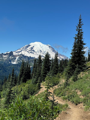
As can be seen, many of these are repeats from prior years.  Bob has reserved a day for us at Mt Rainier next week. 


Thursday, August 22, 2024

If this is Thursday it must be postcards, 673


Grand Prismatic Spring, Yellowstone National Park


This unused Yellowstone Forever postcard features a picture by Steve Hinch of the Grand Prismatic Spring.  The card was purchased at the Bear World gift shop on a recent trip to Yellowstone Park.  There is a blurb at the upper left on the reverse:  “Yellowstone National Park.  After witnessing an eruption of Great Fountain Geyser, one early explorer observed:  ‘We could not contain our enthusiasm; with one accord we all took off our hats and yelled with all our might.’  Surrounding the geyser is a spectacular array of terraced pools that in this photo reflect the evening sunset.” 


Our recent trip was an extended family gathering held near West Yellowstone.  We have a senior National Park pass which allowed us as many visits to the park as we could fit in between the scheduled activities with the group.  The first day we stopped to go around the boardwalk by the Grand Prismatic Spring it was extremely windy and cold.  When the hot steam from the pools blew warm air on us it smelled like sulfur but the warmth was welcome despite the smell.  On another day, when the entire group went, it was not only still windy the blowing steam was so thick that nothing much was visible from any point along the boardwalk.  The photos below are from the day of our first trip.


The fountain pool


The Great Fountain Geyser mentioned in the blurb, erupts every 9 to 15 hours.  Between eruptions it is just a deep, steamy pool.  A section of the looping boardwalk can be seen at the upper right side of the picture.  In 1959 there was a significant earthquake in the park that changed some of the features and made predicting some geyser eruptions more difficult.


The fountain pool from another angle


Streams of hot steamy water flowing out of the pools above


A section of the one-way boardwalk loop.  This is about a ½ mile loop that felt a lot longer due to the high winds.


Grand Prismatic Spring, similar to picture on the card


 Closer view of the Grand Prismatic Spring showing some of the amazing color variations.


The Grand Prismatic Spring was first recorded by early European explorers and surveyors.  A group of four trappers from the American Fur Company described it in 1839 as a “boiling lake” with a diameter of 300 ft or 90 m.  The colors are produced by mineral rich water and range from green to red.  The deep blue in the center of the pool comes from the water itself.  The strongest color effect is in the center of the spring due to the depth and sterility of the pool.


For additional information, see:


https://en.wikipedia.org/wiki/Grand_Prismatic_Spring

https://en.wikipedia.org/wiki/Great_Fountain_Geyser

https://www.nps.gov/places/000/great-fountain-geyser.htm


Thursday, August 15, 2024

If this is Thursday it must be postcards, 672


Boeing 314 Clipper


This is the second postcard purchased at the Seattle Museum of Flight.  Featured on the card is the Boeing 314 Clipper introduced in 1938.  The card is a reproduced vintage illustration by Foundimage.com and has NV 388 at the lower right corner on the reverse. 


This plane was developed by Boeing around the same time as the Stratoliner, found on last week's postcard.  The 314 Clipper has been described as an American long-range flying boat made between 1938-1941.  It was one of the largest aircraft and had sufficient range to cross the Atlantic and Pacific oceans.  Twelve of these planes were built, nine were flown by Pan American World Airways (Pan Am).  British Overseas Airways Corporation (BOAC) and the United States Navy also used these planes. 


Looking to expand, Pan Am requested a trans-Pacific airplane and Boeing’s bid was accepted.  Originally Pan Am ordered six planes, then later ordered six more improved planes with increased engine power and room for 77 passengers.  Because of World War II some passenger air routes were unable to continue service, hence Pan Am agreed to sell three of the six under construction to the United Kingdom.  The BOAC planes were primarily intended for flights between the UK and West Africa.  Also, Pan Am’s Clipper fleet was pressed into US military service during WWII ferrying people and equipment to the Pacific and European fronts. 


A bit of trivia:  Each passenger was allowed up to 77 pounds of baggage free.  Extra weight over the limit was charged $3.25 a pound.


For additional information, see:


https://en.wikipedia.org/wiki/Boeing_314_Clipper

Thursday, August 8, 2024

If this is Thursday it must be postcards, 671


Tourism advertisement postcard


Today’s unused postcard is one of two cards that were found and purchased at the Museum of Flight in Seattle a few years ago.  It is a Foundimage.com product and features a vintage advertisement for the travel industry.  The destination shown on the card is Equatorial Africa.  The airplane shown on the card is a Boeing 307 Stratoliner or Strato-Clipper, introduced in 1940 and used by Pan American Airways, and also used by the USAAF as a C-75.  TR-48 appears at the lower right corner on the reverse.  There is no blurb or other information on this divided back card.


This plane had the first pressurized cabin, a cruising speed of 200 mph at 20,000 ft.  By contrast, a competitor, the Douglas DC-3, went 160 mph at 8,000 ft.  For commercial service the four-engine prop plane had a crew of five or six people:  two pilots, a flight engineer, two flight attendants, and a navigator (optional).  The plane held 33 passengers, later increased to 38, and finally to 60. Only ten of these planes were built.


During the 1940s, 1950s and 1960s traveling by air was much different than today.  It was still somewhat of a novelty.  Passengers had more legroom, and aisles were wider too.  There were no First class and economy seats, all seats were in one cabin.  It was a glamorous experience for only for the relatively wealthy.  There were “postcards from the sky” to send to friends and family.  Multi-course meals were served with “white linen, silver cutlery and fine china dinnerware were the order of the day.” 


Exotic destinations like that of Equatorial Africa, which is roughly the equatorial region of the sub-Saharan Africa along the Equator, and the tropical African rain-forest area, were advertised to entice the world traveler.  The poster art on the card shows elephants and palm trees.  This type of travel would also have been something that would be beyond the plans and budgets of the average person.


The region called French Equatorial Africa consisted of the French colonial territories of Gabon, French Congo, Ubangi-Shari, and Chad from 1910 to 1958.  These territories became new republics in 1959 as the Union of Central African Republics and then later fully independent in 1960. 


For additional information, see:


https://www.galerie123.com/en/poster-history/travel-poster/

https://imagesofvenice.com/history-of-travel-posters/

https://simpleflying.com/the-golden-age-of-flying-guide/

https://en.wikipedia.org/wiki/Boeing_307_Stratoliner

https://en.wikipedia.org/wiki/French_Equatorial_Africa

https://en.wikipedia.org/wiki/Equatorial_Africa


Thursday, August 1, 2024

If this is Thursday it must be postcards, 670


Grizzly Bears, 2010


Here are three unused postcards recently purchased from the Yellowstone Bear World gift shop. This card above was distributed by Great Mountain West Supply of S.L.C., Utah.  The photograph is credited to Roger A. Holcomb.  There is a blurb at the upper left on the reverse: “Yellowstone Bear World Grizzles.  The male and female grizzlies are one of the few breeding pairs in captivity.  Grizzlies are naturally aggressive animals and are carnivores.  Grizzlies have massive bodies and their sense of smell is much more acute than their hearing or sight.  They fear no other animals aside from humans.”


The second card is also a product of Great Mountain West Supply of S.L.C., Utah.  The photo was taken by Andies Bear Production.  


Grizzly Bear


The blurb at the upper left on the reverse of this card:  “Grizzy bear is a large powerful bear of western North America.  The hump on the shoulder distinguishes them from other bears.  The grizzly bears at Yellowstone Bear World located in Rexburg, Idaho are a highlight of the drive through wild life park.  Their massive bodies, and huge claws on all four paws are truly awesome.”


Approximately 30 to 35 bears were in the drive through park.  All of them were free roaming, hence the caution of driving slowly, 2 or 3 mph, no stopping or getting out of the vehicle, and keeping windows rolled up.  The majority of the bears in the park were black bears but we also saw a few grizzlies as well. 


Grizzly bear in the snow


The third card is a product of Yellowstone Forever and features a photograph by Steve Hinch.  The blurb at the upper left on the reverse:  “A frosty grizzly bear frolics in the snow.  Grizzly bears hibernate through the winter, but occasionally will emerge from their dens before spring depending on conditions.  During hibernation bears do not eat or drink, and they recycle their urine and feces.  Once they emerge, they quickly search for food to replace the up to 30% loss of body fat they experienced during their winter’s sleep.”


In addition to Bear World we also visited the Bear and Wolf museum in West Yellowstone.  The animals were not caged but were in enclosures, there were some viewing windows and some open-air viewing stations well away from the animals.  This was more like a zoo than the drive through safari experience of Bear World.  There were teams of three bears that were rotated every couple of hours so that no bears got tired of being on display.  The areas were designed to resemble life in the wild as much as possible. 


One bear was cooling off on a hot day


Another bear was wandering around in the enclosure


 The staff member at the wolf exhibit explained that when the wolves came in for a rest the keepers would place animal scent, such as deer and other prey animals, around the enclosure, and place raw meat hidden in the stream, for example, so the wolves would have to hunt for some of their food.  These animals are normally shy of humans and the keepers do not go into the enclosure when the animals are out.  Even so, the staff member said the animals have adjusted to having people look at them through the glass or from the viewing stands, making it impossible to ever reintroduce them back into the wild. 


This wolf posed for a photo


For additional information, see:


https://www.nwf.org/Educational-Resources/Wildlife-Guide/Mammals/Grizzly-Bear

https://en.wikipedia.org/wiki/Grizzly_bear