Thursday, July 28, 2022

If this is Thursday it must be postcards, 566


Polynesian Cultural Center, Oahu, Hawaii


The color photograph featured on this postcard is credited to John Wagner.  The unused card has the number #1576-H and a note:  “The beautiful pageantry of Hawaii is viewed at the Polynesian Cultural Center” at the lower left on the reverse.  The card was published by IMPACT “Life Like Photo Art.”


“The Polynesian Cultural Center (PCC) is a family-centered cultural tourist attraction and living museum” found on the northern shore of Oahu, Hawaii.  There are 8 simulated tropical villages representing the major Polynesian cultures of Hawaii, Samoa, Aotearoa (present-day New Zealand), Fiji, Tahiti, Tona, and the Marquesas Islands, with performances demonstrating the arts and crafts of Polynesian cultures.  In addition to the villages there is a special exhibit dedicated to Rapa Nui (Easter Island).  About 70% of the 1,300 employees are students at BYU-Hawaii.  Students can work up to 20 hours per week during the school term and up to 40 hours a week during breaks.  PCC is a non-profit organization.  Revenues generated are used for the daily operations and to support education.  Over 12,000 BYU-Hawaii students have benefited from financial assistance provided by PCC.  The PCC is owned by the Church of Jesus Christ of Latter-day Saints, and occupies 42 acres or 17 hectares of land belonging to nearby Brigham Young University.


The PCC is one of the most frequently visited tourist destinations in Hawaii and attracts about 700,000 visitors a year.  Since 1963, when it opened, 32 million people have visited the center.  Also available are rental canoes with or without a guide that can be paddled in the lagoon that runs through the park.


Evening lu'au performance


In the evening there is an extra option of attending a lu’au which offers traditional food and entertainment.  The postcard below shows a portion of the evening entertainment program entitled:  “This is Polynesia.”  The card is published by Island Heritage with a photo by D. Busath.  


For additional information, see:


  https://en.wikipedia.org/wiki/Polynesian_Cultural_Center


Thursday, July 21, 2022

If this is Thursday it must be postcards, 565


Hanauma Bay, Oahu, Hawaii, ca 1986


This is a Travel Card Collection postcard published by IMPACT, 1985.  At the lower left corner on the reverse is the number #1682 with the note:  “Hanauma Bay – located just minutes from Waikiki by car or bus is a snorkeler’s paradise (a must see).  One of the most popular attractions for young and old alike.  Photographer:  William Waterfall”


Bob has several unused postcards featuring Hawaiian scenes that I will post in the next few weeks.  He tells me that one of his best swimming memories is snorkeling in the bay where the water was very warm, pleasant and clear.  The card has an aerial view of Hanauma Bay on the island of Oahu.  This location is one of the most visited places in the Hawaiian Islands and has suffered somewhat from over tourism.  In addition, in the 1950s portions of the reef were blasted out to make room for telephone cables linking Hawaii with the west coast of the United States.  Before 2020 Hanauma Bay had an average of 3,000 visitors a day.  During the COVID-19 pandemic and to allow fish to feed the bay is now closed Mondays and Tuesdays.  The park has limited the number of visitors per day to 720 and requires reservations for all non-residents.


Hanauma Bay is a Nature Preserve and a Marine Conservation District.  Laws were enacted to protect the marine animals and to prevent damage to the coral heads.  Visitors are cautioned to avoid contact with coral or marine rocks that can cut the skin and could cause medical problems.  There are about 400 species of fish inhabiting the bay.  Green sea turtles known as Honu are abundant in the area.  There is also an abundance of parrotfish. 

For more information, see:


https://en.wikipedia.org/wiki/Hanauma_Bay


Wednesday, July 20, 2022

DeRoux, Teanaway, 2022


DeRoux, Teanaway, Wenatchee National Forest

The last time we were here it was with a Mountaineers naturalist class in mid summer with temperatures in the 90s F.  This year it has been cooler and a check of the weather made it possible to visit on a more comfortable day.  As the sign shows, this trail is open to hikers, mountain bikers, horses, and motorized two wheel bikes but closed to three and four wheel ATVs and other vehicles.  We saw no evidence of motorized use and no bike tracks.  There were 3 horse trailers and 2 cars in the parking area when we arrived.  There were signs that horses were using the trail but we did not encounter any while we were hiking.  


DeRoux Falls


DeRoux is in the Teanaway, part of the Wenactchee National Forest.  The Forest Service Pass is required.  There is an outhouse at the trailhead.  Because it is on the east side of the mountains there are some plants that are not found on the wetter, cooler, west side.  We had a double goal, to see the rarely photographed DeRoux Falls and enjoy the flowers.  We could hear the roar of the falls as we got close but the falls are not visible from the trail.  In a couple of places near the falls a short off the trail walk offered good views.  These off trail sites do have faint paths to point the way but unless one knows the falls are there it is unlikely that hikers would see them.


Bob at one of the off trail viewing areas for DeRoux Falls


 DeRoux Creek


This is in an open mixed forest of mostly pine and fir trees.  The dead trees, from fire or disease, have whitened and are sometimes called ghost trees.  The DeRoux creek parallels the trail in places and disappears in the woods in others.  


Davidson's or Cliff Penstemon

 Woodland Penstemon


We saw these two kinds of Penstemon, the bright pink cliff variety or Davidson's Penstemon, and the more usual woodland variety with a blue-purple color. There are several different Penstemons.  We have coastal Penstemon growing in our home garden, so it was fun to find two other kinds in the woods.


Vetch


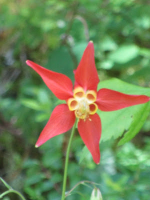
Columbine


Queen's Cup
 
 
Sitka Valerian

 
Rosy Pussytoes

 
Bracted Lousewort
 

Phlox

 
Lewisia Columbia
 

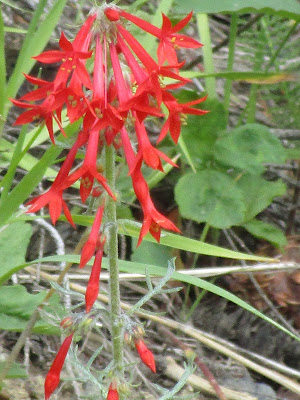
Scarlet Gilia also called Skyrocket


Tiger Lily


California False Hellebore

All parts of this plant are poisonous to humans and cattle.  It is sometimes called California Corn Lily and differs from the "normal" false Hellebore or Corn Lily we usually see that has drooping greenish flowers instead of white flowers that grow upward.  There were thousands of these plants all along the roadside making a splendid looking display.  Until we discovered how poisonous they were we were quite taken with their appearance.  


Honeysuckle

 
Arrowleaf Balsam Root
 

This strikingly beautiful black and white, with a little orange, butterfly or moth wouldn't open its wings all the way but waited patiently while I took a picture.  I couldn't identify it for sure. 


Count for the day:  0 hikers, 0 dogs

4 miles RT, 750 ft elevation gain

Thursday, July 14, 2022

If this is Thursday it must be postcards, 564


The Teller House, Central City, Colorado


Two postcards are being shared this week.  The above card is an unused Curteichcolor, 3-D Natural Color Reproduction postcard published for Flatiron Postcard Company, of Boulder, Colorado.  Bob McMillian is credited for the color photograph.  The number 243 appears at the lower left corner on the reverse with the note: “The Historic Teller House, Central City, Colorado.  Built in 1872 at the cost of $107,000.”  Both cards were shared friends K & J.


Teller House is described as a historic hotel in Central City, Colorado.  The building has also served as a casino (1991-2000, 2005), and a restaurant.  It is listed on the U.S. National Register of Historic Places.  The bar at Teller House is famous or well known for the “Face on the Barroom Floor,” shown on the second postcard below.


Face on the Barroom Floor


The painting of a woman’s face on the wooden floor was painted by a local artist, Herndon Davis, as a joke in 1936 after he was fired by the hotel.  The unused card has the number 233 at the lower left corner on the reverse.  The card has decorative cut edges.  The photograph is attributed to Ted and Lois Matthews.  This card is also a Flatiron Postcard Co. publication, this one printed in Australia by Colorscans.


Herndon Davis was born in 1901 in Wynnewood, Oklahoma and moved to Denver, Colorado in 1936.  He was an American artist, journalist, illustrator and painter.  When he worked at the National War College in Washington, D.C. he created maps of China and Japan.  His illustrations appeared in New York, Washington, D.C., and Denver newspapers.  He also made paintings and murals by commission.  While in Denver his works captured people and landmarks of the west.  The painting on the barroom floor is of his wife, Edna Juanita (Nita) Cotter.  Among his varied works are landscapes, places, buildings, and portraits.  Many of his works were done in watercolor and some no longer exist.  The Herndon Davis Collection is in the Western History and of the Denver Public Library.  Davis had just started a commissioned mural for the Smithsonian Institution when he died of a heart attack in 1962.


 Thanks to K & J for sharing the cards.


For additional information, see:


https://en.wikipedia.org/wiki/Teller_House

https://en.wikipedia.org/wiki/Henrdon_Davis


Thursday, July 7, 2022

If this is Thursday it must be postcards, 563


Crown Point, Columbia River Highway, Oregon, 1915

[Photo:  by Weister]


It is interesting and fun to find postcards that show familiar places as they were and as they became or are today.  The above card has a black & white vintage photograph of Crown Point taken by George Weister in 1915, before Vista House was built.  All three cards shared this week were purchased at the Vista House Gift Shop and are distributed by Friends of Vista House in partnership with Oregon Parks & Recreation.   


Dedication of Vista House, Columbia River Highway, Oregon, 1918
 

This second card has a photograph from the day of the dedication of Vista House, 5 May 1918.  At the lower front right corner is written:  #405, Cross & Dimmixx. 


Vista House, Crown Point on Columbia River Highway, ca 1920


The third card, above, has an aerial black & white photograph from the 1920s showing Vista House.  No photographer is credited.  All the cards are linen textured.  Bob and I visited here in 2014 and an earlier postcard Thursday #140 with modern postcards and a few other photos can be found by putting Vista House in the blog search option. 


Vista House is built on a basalt promontory on the Columbia River Gorge called Crown Point.  The promontory, 733 ft or 223 m above the river, has also been called Thor’s Heights or Thor’s Crown.  The Point was designated a National Natural Landmark in 1971 and has spectacular views of the river and gorge.  Vista House, built in Art Noveau style, was opened to the public in 1918.  It is an observatory that serves as a memorial to Oregon pioneers and also as a rest station for travelers.  The building is listed on the National Register of Historic Places.


River view from upper level of Vista House, 2014


The approach to Vista House, 2014


Distance view of Crown Point and Vista House from the highway


The photographer credited on the 1915 picture, George M. Weister, was born in 1862 in Pennsylvania.  He was first a salesman for E. J. Partridge Photographic Supply Company operating out of Portland, Oregon in 1890.  Five years later, in 1895, he opened his own photography business called Weister Company where he acted as a photographer but also sold photographic supplies, lantern slides and cameras.  After Weister died in 1922 his co-worker acquired the business and an extensive collection of Weister’s negatives that were donated to Whitman College and Northwest Archives by Mrs. John D. Watson in 1979.  The photographs, some as early as 1880, date primarily from 1890 to 1920.


For additional information, see:


https://en.wikipedia.org/wiki/Crown_Point_(Oregon)

https://en.wikipedia.org/wiki/Vista_House

https://archiveswest.orbiscascade.org/ark:80444/xv546538


Monday, July 4, 2022

Lower Big Quilcene, 2022


Trail sign for Lower Big Quilcene at the trailhead


This is a trail that Bob had been on many years ago but I had never been on before.  It is located on the Olympic Peninsula which meant an early start for us that included the Edmonds ferry to Kingston.  Summer ferry wait times can often be an hour or more.  We were prepared for long waits but ended up getting to Edmonds just as the ferry arrived and made it on the outgoing ferry without much of a wait at all.  On the return trip we were in lane 18 and felt certain we would have to wait at least an hour for the next ferry but managed to be one of the last few cars getting on.  Still a long day for us but worth it.  This is another low elevation hike since there is still too much snow at higher elevations.


Native Rhododendrons


The Lower Big Quilcene trail requires the Forest Service Pass.  There is a frequently serviced, clean, small, older outhouse at the trailhead.  The parking area was almost full when we arrived.  Bob chose this trail at this time of year so we could see the native rhododendrons in bloom.  They grow along the Pacific coast from southern British Columbia, Canada to northern California. The Rhododendron is the Washington state flower.  The weather has been cool this year and the flowers are late coming, but rhodies were indeed in bloom, dotting the trail almost all the way along, and beautiful to behold.  I took so many pictures of rhododendrons it was hard to choose which ones to share. 


Most of the trail surface is packed dirt and needles


In one place there was a downed tree to step over


River view


The surface of this trail is nice, packed dirt with needles, not many rocks or roots.  It is mostly level with a few ups and downs.  Like everywhere else we have hiked this year there was some mud; however, the needles help make it less messy.  We gained a total of 400 ft elevation, with a 5.6 miles RT.  The sound of running river water was often audible.  The river was visible from the trail in places with sturdy bridges crossing over the river in others.   


A section of the Bark Shanty campground.  The Forest Service trail crew had been in cutting and clearing downed trees.


The river running right along side the campground area


One of three bridges that cross the river.  This bridge is near Bark Shanty.


Our turn around point was the Bark Shanty campground.  This is a large open space with cut log benches located right alongside the river.  On the way in we met a group of 12 girls scouts with 4 adult leaders who had camped at Bark Shanty and were on the way back to the trailhead.  It turned out that most of the cars in the parking area belonged to this group.


 Other flowers:


Bunch berry also called Canadian Dogwood


Columbine

Spotted Coral Root


 Honeysuckle

Miner's Lettuce


Orange Indian Paintbrush
 

Star Flower
 
 
Thimbleberry


We saw this doe and fawn, but before I could get a good picture they got spooked and ran away. 
 

Count for the day:


30 hikers, 2 dogs, and 3 deer seen on the drive out

5.6 miles RT, 400 ft elevation gain