Thursday, March 28, 2013

What happened to Ingeborg, Update


Graslia, Vest Agder, Norway

This photo of the cover of the 2012 Vennesla Historielag appeared in the blog on 27 January 2013.  After the post went out Rune Jensen sent me another email explaining that this image is of Graslia and shows the house he grew up in.  His parents still live there.  It is the third house from the right in the row by the large barracks across the river. 

Olaug & Mikal

He was also able to provide the identities of these two people in the snow trench as his grandparents Olaug and Mikal not Ingeborg and Olav as I had thought they might be.

Thank you so much, Rune, for sending the additional information.  I am always very pleased to put more of the pieces together and get the names and places figured out correctly.

All the photos are from the Vennesla Historielag.


If this is Thursday it must be postcards, 84


Paradise Ice Caves, Rainier National Park


Reverse

 Mt. Rainier, Washington, ca 1909

At one time there were ice caves at Paradise at Mount Rainier.  The postcard does not do justice to the color of the caves.  I can remember going there one summer around 1966 or 1968 and marveling at the intense blue color of the ice.  We went in late August, the sun was shining and the entrance to the caves was dripping large drops of ice water.  After a fairly long hike to get up there on a warm day the breeze by the caves was wonderfully refreshing and cool.  We did go inside just a short distance and did not stay long since it was very wet and dripping inside.  These caves were also known as the Paradise Glacier Caves and consisted of an extensive series of interconnected ice caves. 


Seal of the Alaska Yukon Pacific Exposition, 1909

The postcard has the 1909 Alaska Yukon Pacific Exposition seal on the reverse dating it to 1908 or 1909, telling us that people had been visiting the caves even as early as that time.  The caves were only open for a short period of time in the late summer and sometimes not every summer.  The maximum length of the cave system was surveyed at 13.25 kilometers or a little over 8 miles in 1978 making them the longest mapped such caves in the world.   Sadly, by the mid 1980s the caves no longer existed because of glacial recession.  


In 1906 Paradise Glacier was one vast ice sheet.  By the 1930s the glacier had separated into two sections, upper and lower.  If a glacier is moving substantially the movement closes up the cavities that form the caves and therefore the ice caves disappear.  The caves are formed under stagnant, melting sections of the glacier.  By the 1980s the glacier had retreated to the upper half of the valley that had formerly been filled with ice caves.  A glacier cannot survive without accumulation and snow cover that lasts even through the summer months. 
Today there is no remaining snow cover that lasts throughout the year on either the upper or lower sections.


1908 Series Stamp, Franklin profile

This is a used card that appears to have been sent by Bessie to herself.  The stamp is from the 1908 series and has a Benjamin Franklin profile.  These stamps were in use between 1908 and 1922. 

For more information, see:
http://en.wikipedia.org/wiki/Washington-Franklin_Issues
http://en.wikipedia.org/wiki/Paradise_Ice_Caves
http://glacierchange.wordpress.com/2010/04/29/paradise-glacier-ice-caves-lost/

Saturday, March 23, 2013

Oak Grove Cemetery, Marietta, Ohio


 Entrance to Oak Grove Cemetery

Oak Grove is the other cemetery that I passed on daily walks.  It is a large cemetery comprised of 33 acres, covering a hilly area in the town of Marietta, Ohio.  I walked up the hills and around the hills and wanted very much to get to the top of the main hill where there was a monument of some type but it had been snowing, the ground was slippery, no stairs or paths led up to the top, and it was steep so while I was fairly confident I could climb up to the top I was worried about getting back down without falling or slipping.  After I returned home my son and his wife did climb up to the top and took a couple of photos for me. 


Q standing by the monument at the top of the hill Oak Grove Cemetery


The front of the monument erected for the 50th anniversary of the founding of the cemetery


The plaque says in part:  “50th Anniversary of Oak Grove Cemetery, 1860 Mayor 1910 William A. Whittelson, Solicitor Franklin Buell, Clerk John Tash (?), Treasurer John A Grimm (?), Civil Engineer Alexander L. Haslun.  Council—1st Ward, 2nd Ward, 3rd Ward” with names not clear enough to read.


Views from the top of the hill

The town purchased land for the cemetery in 1860 or 1861 with the first two burials being little children.  The first adult buried here occurred in 1864.  I did see one poignant tombstone that simply said “Little Maude” infant daughter of . . .” with the date.   Many of the stones are so old and made of limestone so the inscriptions are either worn or covered in moss and lichen making them at times difficult to impossible to read.


Unlike the Mound Cemetery this one does have an office and also a mausoleum and this other building above that looked as if it may have at one time been a small chapel.  The grounds are nicely kept but the road and path surfaces could use a little help as is evident from the picture at the top.  Many of those buried here are Civil War veterans but there are few of the Revolutionary War star markers as well. 


The size of this cemetery in such a small town is amazing.  Although I meandered around several times taking different routes I never did walk the entire grounds. 


This view gives a little bit of an idea of the hills and also the snow was still on the ground in places. 


There were labels by some of the trees including this large Hickory tree.  Elms and Hickories are not common in the Northwest yet references to them often appear in books so I was curious and a bit sorry that the leaves were not yet out so I could see what the tree would like in its “summer dress.” 


The Grand Army of the Republic (G.A.R.) is an organization that Civil War veterans and their descendants can join.  Thomas LeRoy Ford who was the husband of Margaret (Maggie) Lorig, was a member as was his son Ralph Ford. 


Civil War graves

Thursday, March 21, 2013

If this is Thursday it must be postcards, 83


Crater Lake, Oregon

The photograph on this postcard is by Frank Patterson who specialized in outdoor photos particularly of the Crater Lake area in Oregon.  Patterson was born in Klickitat, Washington in 1883, began his career early in the 1900s and died in California in 1961.  At one time 228 dealers sold his postcards.   This card was sent to the Lees by their friend, Ida, and is dated 18 August 1927.

Crater Lake is a caldera lake and is famous for its deep blue color and clear water.  The lake was formed when the volcano Mount Mazama collapsed about 7,000 years ago.  It is the main feature of the Crater Lake National Park.  The lake gets its water from rain and snowfall, there are no rivers feeding in or emptying out.  Fish were introduced to the lake and several species have since formed permanent populations. 

Crater Lake is 5 by 6 miles (8 by 10 kilometers) across with an average depth of about 1,148 feel (350 meters).  The maximum depth was measured at 1,948 feet (594 meters) making it the deepest lake in the United States and the second deepest in North America.  As noted in the message on the reverse of the card, the rim of the caldera ranges from 7,000 to 8,000 feet in elevation.  The lake water is very pure in terms of the absence of pollutants perhaps because it does not have tributaries or inlets. 


Reverse


The stamp is from the 1922 series that was in use during the 1920s and 1930s.  The designs mostly featured former United States presidents such as this 2-cent version with the profile of George Washington on it. 


Enlarged Washington 2 cent profile stamp

For more information see:

http://en.wikipedia.org/wiki/Postage_stamps_and_postal_history_of_the_United_States
http://en.wikipedia.org/wiki/Crater_Lake
http://www.oldoregonphotos.com/photographers/frank-patterson.html

Tuesday, March 19, 2013

Mound Cemetery, Marietta, Ohio


Mound Cemetery, Marietta, Ohio

While in Marietta, Ohio I took walks almost every day.  Some of the walks ended up being more than 4 miles and were a surprise to me since it did not feel like I had walked that far.  There are two cemeteries that I often passed when walking, the Mound Cemetery and the Oak Grove Cemetery.  The Mound Cemetery is so named for the ancient Hopewell mound located there.  The mound is known as the Great Mound or Conus.  It is thought to date from 100 BC to 500 AD.   As noted in the postcard Thursday last week Marietta was founded in 1788 as the first settlement in the Northwest Territory.   The land for the cemetery was donated by General Rufus Putnam in January 1801 with the first burial taking place that same year in October. 


Informational placard


The placard gives a brief history and has a key to the graves of important people buried there including Revolutionary War veterans. 

It is a rather pleasant, quiet place to stroll around.  The mound has stairs to the top and benches to sit on once one is up there.


The mound

Revolutionary War officers and soldiers were the pioneers of Marietta most coming from Massachusetts.  Land grants were given to veterans as payment for military service.  The Daughters of the American Revolution publication of Jan-Jun 1900, American Monthly, stated that there are more officers of the Revolution buried in the Old Mound Cemetery than in any other place in the United States.  A small section with flags and memorial stars has the names of several Revolutionary War veterans.  


Flags and Stars with names of Revolutionary War veterans


Close up of a star

The French General, Lafayette, visited Marietta in 1825.  He had fought with the Americans during the Revolution and a quote from him is engraved on one corner of the cemetery:  “I knew them well.  I saw them fighting the battles of their country . . . They were the bravest of the brave.  Better men never lived.”


Views from the top of the mound


The cemetery is fenced, not very large and is situated in the middle of a residential area.   For more information and photos:

http://familytreemaker.genealogy.com/users/n/i/t/Debra-Nitsche/FILE/0157text.txt
http://www.forgottenoh.com/Cemeteries/mound.html
http://en.wikipedia.org/wiki/Mound_Cemetery_%28Marietta,_Ohio%29

Thursday, March 14, 2013

If this is Thursday it must be postcards, 82


Campus Martius

As some of you know I just returned from two weeks in Marietta, Ohio where I was visiting with my son and his family.  While there I went to the Campus Martius museum where I found this postcard showing the Northwest Territories first settlement in Marietta constructed during the winter of 1788-1789. 


Sign in front of the museum


The Campus Martius museum building

The museum is built around the home of General Rufus Putnam who was in charge of the settlement.  The fort housed about 50 men and the Putnam family.   Men who had served in the Revolutionary War were given land grants in what was being called the Northwest Territories as payment for their military service.  Many of the houses in Marietta today have plaques telling the history of the home and the name of the original owner.   On my daily walks I would take time to read some of these plaques and also to visit the Mound Cemetery where several Revolutionary War veterans are buried. In a future post I will put up some photos of the cemetery and a little more information.

 
The bell said to have been gifted to the town of Marietta by Marie Antoinette of France.
 
 
The town of Marietta is named after Marie Antoinette of France and the story is that she gifted a bell to the town.  That bell is currently displayed at the museum in the reconstructed Putnam house.  Here below are some photos of the Putnam house.


The living room or parlor of the Putnam House
 

The kitchen in the Putnam house


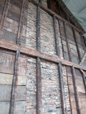
A section of the exterior wall of the Putnam house to show the construction method.


There is a PBS documentary called “Opening the Door West” that has more images.  Visit www.OpeningTheDoorWest.com for more about this award winning program.

Thursday, March 7, 2013

If this is Thursday it must be postcards, 81


 Saint Clément Aqueduct and garden

The postcard above and the picture below show a view of the Saint Clément Aqueduct built in the 18th century as it was years ago and as it is today.   Today the trees reach the top level of the aqueduct or higher.  Compare with the vintage postcard and notice how small the trees are.  The second photo below shows another view.  The figure at the lower right corner provides some size perspective.


Trees near the aqueduct as they are today


Triumphal arch with water tower in the background

The vintage card above shows the triumphal arch or “Porte du Peyrou” that was built at the end of the 17th century.  Part of the aqueduct can be seen at the upper left side just in back of the water tower.  The water tower also has an arch shaped opening that balances the triumphal arch.   In the center of the park is the statue of Louise XIV.  Once again the small figures show how large the structures are. 


Three Graces fountain, Place de la Comédie

The statue of the Three Graces is a reproduction.  The original statue is now in a museum. 


Place de la Comédie

The streets to the left and right lead into the old portion or historic section of the city called the Ecusson and have medieval roots.  Modifications were made between the 16th and 18th centuries with some buildings near the Place de la Comédie dating from the 19th century. 

Thank you to my French friend who sent me these cards and photographs with addition interesting information about them.  I thought they made a nice comparison and contrast between the old and new or Vintage and Modern views.   As mentioned in pervious Thursday postcard posts about Montpellier the city dates from medieval times and is located in southern France in the region of Languedoc-Roussillon, Hérault.  It is the 8th largest city in France and is about 6 miles or 10 k inland from the Mediterranean.  The city is built on two hills and has some narrow, old, streets that give it charm and provide a more intimate feeling. 


Below are some links for additional information:

http://www.montpellier.world-guides.com/montpellier_landmarks.html
http://en.wikipedia.org/wiki/Montpellier
http://www.mytravelguide.com/attractions/profile-79264105-France_Montpellier_Aqueduc_St_Clment.html
http://www.gpsmycity.com/tours/montpellier-landmarks-walking-tour-4638.html