Thursday, October 31, 2019

If this is Thursday it must be postcards, 423


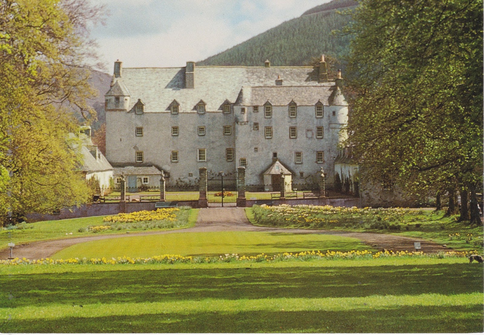
Traquair House, Peebleshire, Scotland

Jarrold & Sons Ltd. of Norwich, UK, printed and published the unused photo postcard above that has a view from the front.  It has the identifier CKTH 10 and the card most likely dates from the 1960s.  Privately owned by members of the Jarrold family, The Jarrold Group was founded in 1770 in Woodbridge, Suffolk, England.  It was moved in 1823 and is currently based in Norwich.  It is a retail and property company.  Beginning in 1823 the company began publishing children’s books.  Greeting cards and postcards came later.   Like the card shared last week this is one that was provided by K & J along with several others mostly from the United Kingdom. 


Jarrold logo found at the top middle on the reverse


Traquair House is the oldest continually inhabited house in Scotland.  It is not a castle but considered a fortified mansion.  Although the house appears to date from about the 15th century the surrounding land was the site of a hunting seat used by Scottish kings from as early as the 12th century.  Ownership changed often during the following 200 years, sometimes it was under the English crown and other times the Scottish throne.  In the 1500s Lady Janet Douglas married Patrick Ruthven, 3rd Lord of Ruthven with whom she had several children forming the main Ruthven line.  Traquair House remained the family seat of the Earls of Traquair for the next four centuries.  In 1875 it passed to a cousin of the Stuarts, Henry Constable Maxwell.


Traquair House Library

Also a Jarrold publication the identifier on this card above is TH 6 and has a photo of the 18th century library.

Traquair House has 50 rooms including a Drawing Room with ancestral portraits and photographs of currents residents; a Museum Room with a mural dating from 1530; The King’s Room, where Mary Queen of Scots stayed in 1556 and which contains relics belonging to her; The Still Room, where breakfast is served; The Dining Room, added in the l7th century; The Library; a Roman Catholic chapel; and, a Brewery that was started in 1965 by Peter Maxwell Stuart.  Stuart incorporated the 18th century domestic brewery equipment used earlier to make beer for the house.  A range of beers is made in the Brewery such as the Jacobite Ale and House Ale brands.  Ale was brewed at Traquair during the reign of Mary, Queen of Scots.  A 200-gallon copper was installed in 1739 the the brew house under the chapel.
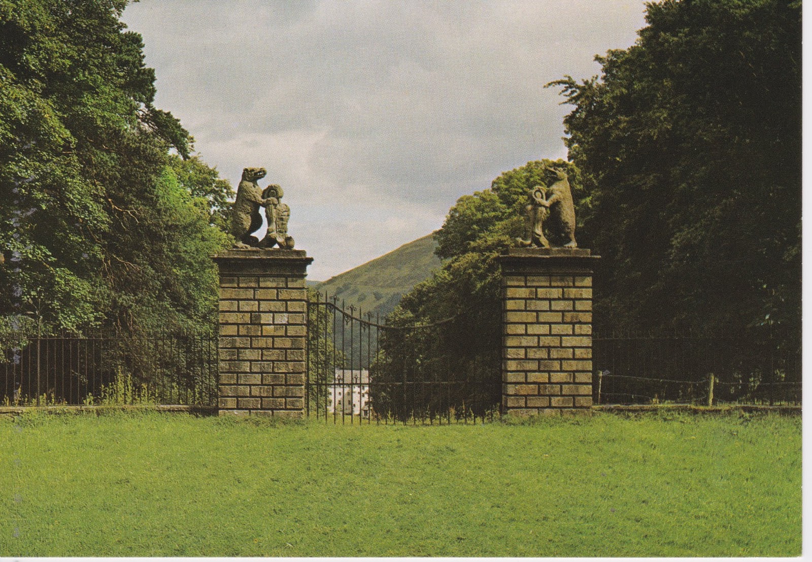


The Bear Gates

The fifth Earl, Charles Stuart, installed the Bear Gates, shown on the card above, at the main entrance to the grounds in 1738.  The card has the code:  PPL/84463/X and was printed by  DRG [J. Arthur Dixon, 1897-1958)] in Great Britain.   The following poem is printed on the reverse of the card:

"Dool an' sorrow hae fa'en Trquair,
  An' the Yetts that were shut at Charlie's comin'
He vowed wad be opened nevermair,
  Till a Stuart King was crooned in Lunnon.

Gone are the Stuarts o' auld Traquair
  Green is the Avenue rank an' hoary,
An' the Bears look doon wi' an angert glare
  On the "Steekit Yetts" an' the vanished glory."

Dixon was a photographer and manufacturer of greeting cards and postcards.  Born at Cross Hills, Keighley, Yorkshire in 1897 he bought a small printing business in 1926 and moved to Shaklin on the Isle of Wight where he resided until his death in 1958.  It is estimated that he produced nearly 30 million postcards. 


Another front view of Traquair House

Another view of the front of Traquair House with the Peebles Ex-Servicemens' Pipe Band in the foreground.  This card is a Pilgrim Press Ltd., Derby publication with the number 17549B.  The photo is credited to Joan Gibson.  Pilgrim Press Ltd. was established in 1934 and is still in operation.

Many thanks again to K and J for sharing the cards.

For additional information, see:

https://en.wikipedia.org/wiki/Traquair_House
https://en.wikipedia.org/wiki/The_Jarrold_Group
https://en.wikipedia.org/wiki/J._Arthur_Dixon

Thursday, October 24, 2019

If this is Thursday it must be postcards, 422


Stonehenge, Wiltshire, England


Anthony & Marée Miles of Salisbury, England published this photo postcard showing a view of Stonehenge.  The card is unused and dates from the 1960s.  It was among several other travel postcards shared by K & J.  The blurb on the back of the card reads:  “Stonehenge, Western Aspect.  An eerie Autumn sunset on massive Sarsens, highlighting 3,500 years weathering.  Clearly visible is the locking-tenon capping the 45-ton remaining uprights of the largest trilithon.”

Stonehenge, added to UNESCO’s list of World Heritage Sites in 1986, is one of the most famous landmarks in the United Kingdom.  A henge is described as being a circular earthwork with a banked enclosure and an internal ditch.  Unlike other henges the bank at Stonehenge is inside the ditch.  The stone part of its name comes from the huge stones place around the circle and the trilithon refers to the top stone that resembles medieval gallows that were constructed of two uprights and a lintel joining them.

From its beginnings Stonehenge was used as a burial ground.  Human bones found here have been dated to 3000 BC or when it appears the bank was first dug.  Burials were continued at this place for about 500 years.  Earlier postholes from about 8000 BC have been found nearby where it is suspected pine posts had been erected and later rotted in place.  The construction spanned approximately 1500 years.  Mounds, larger but similar to the Hopewell Mounds, were also built in the area around that same time period. 

While the original construction may have been made of timbers a transition was made to stone around 2600 BC.  Bluestone, dolerite, came from about 150 miles away in Wales, and Sarsens, sandstone, was found about 50 miles away.  Each monolith measures around 2 m or 6.6 ft and weighs about two tons.  The inward sides of the stones are smoother than the outer surfaces.  Construction techniques used by the builders are unknown.  Proposed functions include an astronomical observatory or a religious site.  In modern times there have been restorations such as re-erecting fallen or propping up tilting stones.  A new car park was built for visitors.  Also archaeological excavations such as the Stonehenge Riverside Project are continuing. 


There are several less famous Stonehenges worldwide including a replica near Goldendale, Washington and called the Maryhille Stonehenge, that was commissioned in the early 20th century by the wealthy entrepreneur Sam Hill and dedicated as a memorial to people who had died in World War I.  Maryhill Stonehenge is constructed of concrete.


 Maryhill Stonehenge


 Views inside the Maryhill Stonehenge circle


The sun as seen through the openings in the Maryhill Stonehenge


 The Columbia River as seen through the stones


 The explanation plaque with a diagram of a typical Stonehenge


The memorial plaque at Maryhill Stonehenge


Thanks to K & J for sharing the Stonehenge postcard.

For additional information, see:

https://en.wikipedia.org/wiki/Stonehenge
https://en.wikipedia.org/wiki/Maryhill_Stonehenge

Thursday, October 17, 2019

If this is Thursday it must be postcards, 421


Byodo-In Temple, Ahuimanu Valley, Kaneohe, Oahu, Hawaii

Movie Supply of Hawaii, Honolulu, distributed the unused postcard shared this week.  It has the alphanumeric code of MS-109 at the lower left corner on the reverse but no photographer is given.  It appears to date around 1968 when this non-denominational Buddhist temple was dedicated to commemorate the 100th anniversary of the first Japanese immigrants to Hawaii. 

The beautiful temple is a smaller scale replica of the original 900-year-old temple at Uji in the Kyoto Prefecture of Japan.  Unlike a functioning Buddhist temple it does not host a resident monastic community nor have an active congregation.   The original temple, constructed around 1052, was made of wood without use of nails but this replica is largely concrete.  It has an 18-foot (5.5 m) statue of the Lotus Buddha covered in gold and lacquer inside the building and a 3-ton brass peace bell outside.  There are Koi ponds surrounding the temple and around the ponds are lush Japanese gardens.  The gardens are also home to sparrows and peacocks.  The Ko’olau Range can be seen in background.  Thousands of visitors from around the world come here each year.  People of all faiths are welcome to participate in its traditions.  The temple grounds are also used for weddings and other meetings.

In addition to this temple the Valley of the Temples Memorial Park also contains large Catholic statues.  There are crypts and mausoleums on the grounds and thousands of Buddhist, Shinto, Protesant and Catholic residents of Hawaii are buried in this memorial park.  Paul Trousdale founded the park in 1963. 

Trivia:  The temple was featured in several episodes of the TV shows Hawaii Five-O and Magnum P.I   The grounds have also been used in the ABC TV series Lost as a stand-in for South Korea and also as the Presidential Villa in seaQuest DSV.  The 2001 movie Pearl Harbor used scenes of the temple as have several other movies. 

For additional information, see:

https://en.wikipedia.org/wiki/Byodo-In_Temple

Thursday, October 10, 2019

If this is Thursday it must be postcards, 420


Map of Tacoma, Washington, 1893

Today’s postcard has a vintage an aerial panoramic map of the city of Tacoma from 1893.  The card was distributed by Lantern Press of Seattle and has the image number 4394.  I found this card in a museum gift shop.  In addition to the street layout the border around the map shows buildings that existed in the city in 1893.

Tacoma is a port city on Puget Sound and is the second largest city in the area.  Its name comes from Mt. Takhoma or Tahoma now known as Mt. Rainier.  While Seattle is called The Emerald City, Tacoma is called The City of Destiny because it was chosen to be the western terminus of the Northern Pacific Railroad in the late 1800s.  It is located 32 miles southwest of Seattle and 31 miles northeast the state capitol, Olympia. 

When I was little the saw mills and paper pulp mills in Tacoma exuded such a strong smell that combined with the smell of the muddy industrial tide flats earned the unfortunate “Tacoma Aroma” moniker.  It was not an altogether pleasant smell.  During the 1990s companies reduced the sulfur emissions by about 90% and that has mostly eliminated the ever-present odor.   In addition to the lumber products, such as pulpwood and linerboard, Tacoma also continues to operate an U.S. Oil refinery on the tide flats that produces 39,000 barrels of petroleum per day.  Tacoma is home to food and candy companies like Brown & Haley, Roman Meal, Mars. 

There are several parks in Tacoma including Point Defiance Park that has a Zoo and Aquarium.  Multi-use trails for biking and walking connect several public parks.  There are museums and historical sites within the city that are worth visiting such as the Museum of Glass where demonstrations of glass blowing are held and handmade glass items can be purchased. 


The bridge connecting the Washington State Museum of History and the Museum of Glass with the two glass pillars.  The museum is housed in what was the Union Station built in 1910 and an enduring emblem of the city of Tacoma.  The central copper covered dome is 90 feet high.  In the 1990s this building was used as a federal court house.  It was put on the register of National Historic Places in 1974.


One of several ceiling panels filled with blown glass


Glass blowing demonstrations are held several times a day


 A window display of hand blown glass ball ornaments


An outdoor pool with a clear glass exhibit

The Washington State Museum of History has a permanent model train display among other historical displays and items.   


 Model trains


Looking down on a life-sized display depiction of what Union Station looked like when it was in operation

For additional information, see:

https://en.wikipedia.org/wiki/Tacoma_Washington
https://en.wikipedia.org/wiki/Union_Station_(Tacoma,_Washington)

Wednesday, October 9, 2019

Three days, three day hikes, Winthrop, 2019


River front cabins, Winthrop, Washington

 Several weeks ago we went on a three-day trip with 15 Happy Hiker friends.  Most members of the group, including Bob and I, stayed in rented cabins along the river and one couple had their own cabin nearby.  The majority of the group went on long, more strenuous hikes, 10 miles round trip and at least 2000 ft elevation gain, for two of the three days.  We chose to start with a modest hike, or hikes, the first day, Rainy Lake and Washington Pass, about 100 vertical gain for a 2.2 mile total.  There were fantastic reflections in the lake, mountain views, and a waterfall.  The second day we went with another Happy Hiker to Cutthroat Lake, 4 miles round trip with 400 ft elevation gain and found fall colors, rocks, squirrels and chipmunks.  The third day Bob and I went to Blue Lake.  An absolutely beautiful place and the most difficult hike I have attempted this year at about 5 miles round trip and an elevation gain of 1300 feet.  Before the Achilles problem this would have been an average hike for me.  In the evenings the entire group met together at a local restaurant to have dinner. 


 Day 1, Rainy Lake & Washington Pass


Trail sign


Rainy Lake is at 4500 ft elevation and Washington Pass is higher at 5500 ft.  The short trail to Rainy Lake is asphalt and wide enough for a wheelchair or walker.  There are several benches along the trail.  There were nice outhouses at each of the trails we visited.


"What do you see, Bob?"


"Reflections in the lake and a magnificent waterfall!"


Bob's zoom-in view of the waterfall


A young couple asked us to take their photo in this spot and in return they took one of us!

From Rainy Lake we drove a short distance to Washington Pass where there were lookout spots for views of the surrounding mountains.  Like Rainy Lake, the trail up to the lookout areas was paved but was probably not suitable for wheelchairs or walkers.


Views from Washington Pass


Looking down on the road below


Clouds rolling in over the mountains

Totals for Rainy Lake & Washington Pass:  22 hikers including two toddlers and an infant in a front carrier, 1 dog


Day 2, Cutthroat Lake


No camping within 1/4 mile of the lake


Munch, munch, munch,  too busy eating to care about people passing by


Cutthroat Creek


Autumn colors


The trail is packed dirt and while not really wide enough to walk side-by-side it is not narrow or overgrown.


Pipsissewa going to seed


This log bridge without rails was about 8 feet above the creek.  Our friend has Parkinson's and decided it was not a good idea for him to attempt the bridge or fording the creek.  I didn't want to chance it with my still healing Archilles and stayed with him while Bob went on the rest of the short distance to the lake. 


Bob's photo of Cutthroat Lake


Amanita muscaria (poisonous)

This very attractive mushroom can be yellow, orange or red with warty white bumps.  Do not eat (or maybe not even touch), it is poisonous.

Cutthroat Lake
Totals for the day:  32 hikers, 4 bikes, and 4 dogs


Day 3, Blue Lake


View of the Liberty Bell group from the road


Fall colors


Another camping sign


We had hoped to see some of the golden yellow larch trees but were just a little too early in the season to see very many. 


Close up of the bright green larch tree needles that will soon turn golden yellow


Blue Lake


The remains of an old log cabin


One of the mountain tarns on the Tarn Loop Trail next to Blue Lake.  There was a nice meadow also.


Ground cover turning red


Looking down on Blue Lake from the Tarn Loop trail


 Sign on the Tarn Loop trail identifying the Liberty Group mountains


 A tree growing in or near a hole in the mountain side


Trail

The Blue Lake trail had some rocks and roots as well as avalanche chutes with loose gravel, rocks and dirt.  On the way down from Blue Lake I fell in an avalanche chute and managed to both sprain and fracture my left ankle.   Bob always carries a first aid kit and was able to wrap my ankle with an Ace bandage.  Then, with slightly more than 1 mile back to the parking area, we inched slowly along.  I am hoping to retire the cane and fancy gray boot in a couple of weeks but the accident has ended my hiking for the rest of this season. 


Oops


Blue Lake
Totals for the day:  In the morning on the way up we counted 73 hikers and 3 dogs, in the afternoon the count had exceeded 100 hikers and some more dogs.   The fall and the mile walk out on sprained and fractured ankle resulted in an incomplete count for the afternoon.