Thursday, August 29, 2019

If this is Thursday it must be postcards, 414


Pittsburgh, Pennsylvania, 2019


This aerial cityscape postcard of Pittsburgh, Pennsylvania has a photo by Dan Amerson.  The card was produced by Gold Star Products and printed in the U.S.A. with an identifying number, GSP-600, at the lower left on the reverse.  The two sports stadiums, Heinz Field, home of the Pittsburgh Steelers professional football team can be found in the foreground, and PNC Park, home of the Pittsburgh Pirates professional baseball team, is found at the middle left.

Usually when we fly to Marietta, Ohio we travel via Chicago, Illinois and Columbus, Ohio, rent a car and drive about 2 ½ hours to Marietta.  This time because we were going for Q’s funeral we wanted to travel and share the rental car with B and that meant getting 3 seats on the same plane. 

B made the travel arrangements and managed to get us on a non-stop flight to Pittsburgh, Pennsylvania, also about a 2 ½ hour drive from Marietta.  All the flights were full and we were extremely lucky to get on the same plane even though we could not sit together.  I am a nervous flyer but Bob was behind me and I could reach over the back of the seat and grab his hand when necessary.  He, in turn, handed me pieces of chocolate every now and then.  B had to bump himself up to first class in order to be on the same flight.

I had never been to Pittsburgh and set about trying to pick up a few postcards and possibly a magnet for the fridge.  No magnets could be found but I did find this postcard and one other that will shared next week. 

Pittsburgh is located at the confluence of the Allegheny, Monongahela and Ohio Rivers and was named in honor of the 1st Earl of Chatham, William Pitt, in 1758 by General John Forbes.  In 1794 the town was incorporated into a borough.   The oldest structure still standing is the Fort Pitt Blockhouse built by the British in 1764.  Boat building and glass manufacturing were early industries; however, the main industry began in about 1830 with arrival of the Welsh immigrants who had been steel and ironworkers in Wales before coming to the United States.  By 1857 Pittsburgh had 1,000 factories and was using 22 million bushels of coal in steel and iron production.  Coal mining and iron manufacturing drew large numbers of European immigrants to the area.  Today in addition to steel production Pittsburgh has high tech businesses as major contributors to the economy.  Before and during the Civil War era Pennsylvania was a free state with active Underground Railroad stations.  There are numerous accounts of people fleeing slavery in southern states that received help from station agents and African-American hotel workers who gave advice about safe routes and safe places to stay.

Heinz Field opened in 2001 and is home to the Steelers and the NCCAA Pittsburgh Panthers.  Prior to Heinz Field the imploded Three Rivers Stadium was used for football and baseball as well as other sports and entertainment.  The new Heinz Field is located on the North Shore and is named for the H.J. Heinz Company famous makers of ketchup.  It also is used for other sports, such as soccer and hockey, and as an entertainment venue for concerts.

PNC Park also opened in 2001 and is home to the Pittsburgh Pirates professional baseball team.  It is also located on the North Shore near the 3 Sisters bridges.  PNC Park is sponsored by PNC Financial Services who purchased the naming rights in 1998.  Heinz Field, PNC Park and the David L. Lawrence Convention Center were all funded in conjunction for $216 million and took only 24 months to complete.  Both Heinz Field and PNC Park use Kentucky bluegrass as their surface.   PNC Park is also used as an entertainment venue.

For more interesting information, please see:

https://en.wikipedia.org/wiki/Pittsburgh
https://en.wikipedia.org/wiki/Heinz_Field
https://en.wikipedia.org/wiki/PNC_Park

Sunday, August 25, 2019

Around Sheep Lake we go, 2019


Approaching Sheep Lake

We have been to Sheep Lake more than once, sometimes as a brief stop on the way to Sourdough Gap; however, until this time we had not walked all around the lake and were not sure it could be done.  The trail around the lake almost disappears in places but there are campsites all along the lakeside so it seemed reasonable that there must be a trail going around.  Yes, there is a way around the lake.  We found an especially nice, private spot at the end of the lake.  It had peek-a-boo views, trees, solitude, and a nice log to sit on for lunchtime.  Our round trip ended up being about 5 miles with a 500 ft elevation gain.  That is pretty good this year for me since my Achilles is still not completely healed. 


Looking out from the trail toward the valley


Narrow, sandy, and a gentle grade most of the way to the lake


The trail is a section of the Pacific Crest Trail and each time we have gone to Sheep Lake we have run into some through hikers.  This time was no exception.  We met a young couple that had started from Mexico in March and were heading to Canada.  They planned on doing 18 more miles that day and were hoping to stay in a cabin since their tent was wet from heavy rainfall the night before.  Lucky for them we still had oranges leftover from lunch that we shared with them—it is called “trail magic” for through hikers and fun for us to do.  We estimated that they probably had already hiked about 5 or 6 miles and at that rate they would make it to the Canadian border in about 2 or 3 weeks.  Total distance on the trail from Mexico to Canada is 2,645 miles. We have a Happy Hikers friend who is currently walking the Way of St. James, medieval Pilgrim trail, from France to Spain.  That route is hut to hut and is about 1,000 miles.  I have great admiration for folks who take on such monumental long distance hikes. 

We didn't expect to find many flowers still in bloom so late in the season and were pleasantly surprised at what we did find.


Columbine


Blue bells of Scotland also called Hare bells


Orange Paintbrush


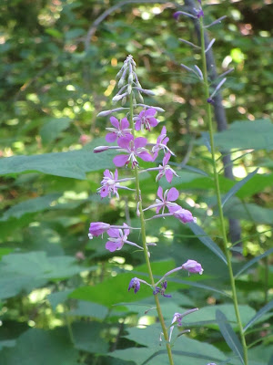
Fireweed


A meadow filled with mountain Aster


Pink Monkey flower, we found a yellow one too


Mountain Ash turning red

The parking area at Chinook Pass serves both Naches Loop and Sheep Lake trails.  There are outhouses, but this time no toilet paper!  


Views of Sheep Lake from the loop around trail


This was not the only dog that jumped into the lake


Western toad in a small stream


Chipmunk


Bird box for Mountain Bluebird


The two horses passed us before we could get more than just the tail . . .

Count for the day:  33 people and 5 dogs, and riders on 2 horses.

Thursday, August 22, 2019

If this is Thursday it must be postcards, 413


Haida Village, Haida Gwaii, Alaska, 1890


Today’s featured postcard is another one I found in a shop in Ketchikan.  Richard Maynard is identified as the photographer on the card dated 1890*.  The picture shows a Haida Village, Haida Gwaii also called Queen Charlotte Islands, off the northern Pacific Coast of Canada.  The blurb on the reverse states:  “Each house in this village was identified with crests which were displayed on mortuary poles and house front.”  The card was printed in Canada and is a Native Elements product, NativeNorthwest.com, Vancouver, B.C., Canada.

There are between 40 and 60 islands in the archipelago that includes the two main islands, Graham Island (Kiis Gwaay) on the north and Moresby Island (Taawxii Xaaydaga Gwaay.yaay linagwaay**—south people island or Gwaay Haanas—islands of Beauty). There are also approximately 150 smaller islands. 

Archaeologists have established that the Haida people have lived on the islands for 13,000 years.  Today form about half of the population.  They have their own acting government called the Council of the Haida Nation.  The islands were formerly known as the Queen Charlotte Islands or “the Charlottes.”  In 2010 the Haida Gwaii Reconciliation Act, in an agreement between British Columbia and the Haida people, renamed them.

The Haida population was around 30,000 inhabitants until the Europeans arrived bringing with them diseases such as smallpox, measles, typhoid, and syphilis.  About 90% of the people died from these illnesses during the 1800s.  By 1900 there were only 350 people remaining and many of the towns and villages had been abandoned.  Today the population living on the islands is about 4,500.  Many of the native peoples moved to cannery towns on the mainland or to Vancouver Island.  The two remaining active island communities are Skidgate, shown on the postcard, and Old Massett, each having a population of about 700 individuals. 

It is not known for certain how the original Haida people came to settle the islands but anthropologists have found striking parallels between the inhabitants of the Kamchatka Peninsula and those of the native peoples of the Pacific Northwest Coast. 

The photographer, Richard Maynard (1832-1907) was Canadian and known mainly for his pictures featuring landscape views of British Columbia, coastal Alaska, and the Pribiloff Islands of the Bering Sea.  Maynard’s wife, Hannah, was also a photographer.  Many of his prints and personal papers were collected by Charles Newcombe.  The negatives of pictures taken by both Maynard and his wife were donated to sold by the son, Albert, to the British Columbia Archives.

For additional information about Haida Gwaii and other examples of Maynard’s photography, see:

https://en.wikipedia.org/wiki/Haida_Gwaii
https://en.wikipedia.org/wiki/Richard_Maynard_(photographer)


———————————————————————————————

*  There is another similar photograph on Wikipedia that is labeled “Houses and totem poles, Skidegate, 26 July 1878 (George Mercer Dawson, Geological Survey of Canada, NAC-PA-37756).”   I’m not sure if both are the same photograph or two different pictures of the same village taken at different times.

**The native names use diacritical marks and letters that I do not have on my computer so these may not be spelled exactly as they should be.

Friday, August 16, 2019

Carbon River, 2019


New Carbon River Ranger Station

The Carbon River trail is another walking trail similar to the Coal Mines Trail.  Originally it was a frequently flood damaged road that led up to the campground by the Carbon River.  The road has been closed to cars for a few years now and the campground is only accessible on foot to backpackers or bicyclers.  It is about 5 miles from the trailhead to the campground and another 3.5 miles to the glacier.  


The road is wide, graveled in most places and tree lined, nice shade on a warm day


This area is an old growth rain forest with huge trees, the majority of which were cedar, fir, hemlock and alder.  It was mined for coal and copper but the forest was not commercially logged.  Bob was our measuring rod and posed by several trees to show how big they are.  While not as big as the trees we saw in the Redwoods, these are still impressive.  We only saw a few tree stumps with notches indicating the trees had been cut down to make way for the road; however, the trail winds around and appears to try to avoid the removal of as many big trees as possible. 


Some of the trees have fallen, or not quite fallen.  Most of the trees have long dangling clumps of witch’s hair lichen hanging from the branches and moss growing on the sides of the trunks.   


 Carbon River with milky glacier water

It is a lovely walk in an old forest and has access in a couple of places to the river.  The water comes from the glacier and is a milky color, extremely cold and is only minutes away from being ice.  


 Bob illustrates how big the trees are . . .


some of the trees had "caves". . .


Wow, 8 feet at the base diameter or about 25 or 26 feet around!

There is also a .3 mile loop hike in the forest that begins right at the trailhead before reaching the main trail.  Part way along the main trail is another .3 mile or about ½ mile round trip offshoot trail to the Washington Mining & Milling Company copper mine ruins.  The trail to the mine starts out level but quickly becomes steep and climbs for most of the way to the mine.


Not many flowers on this woodsy trail the day we were there.  The find of the day was Indian Pipe, the first we have seen this year.  Wildlife was limited to a moth, a Douglas Squirrel, and a few bird calls. 


 Indian Pipe


 butterfly or moth?  we couldn't find this one in any of our books


 He's tiny and blends in but the squirrel is sitting on the log eating a cone nut


The bunch berry or Canadian dogwood had already gone to berry stage


The new ranger station where campers can get a backpacking camping permit is now about 1.5 miles from the trailhead.  The outhouses are still located next to the old ranger station right at the trailhead.  We did approximately 4.5 miles round trip with a brief stop for lunch at the turn around spot. 

Count for the day, 22 people, including a family of 6 on bikes, and two men on bikes with their camping gear in a bike trailer, no dogs.  Note, the bulletin board states that only well trained service dogs are allowed on this trail.  The board also has instructions about what to do if a hiker encounters a bear or a cougar. 


No bears or cougars on our hike

Thursday, August 15, 2019

If this is Thursday it must be postcards, 412


Misty Fjords, Ketchikan, Alaska


When I spotted this postcard in a shop in Ketchikan with a photograph of Misty Fjord National Monument in Alaska by Michael M. Anderson it immediately reminded me of places in Norway.  The card is another “Alaska Joe” original distributed by Greatland Classic Sales Col, Inc. and has the number 82-13BG on the reverse.  The blurb on the card states: “Misty Fjord National Monument is home to incredible beauty with its granite cliffs extending to the sky and its gorgeous blue lakes.”

Located in a portion of the Tongass National Forest in Alaska’s Panhandle, about 40 miles or 64 km east of Ketchikan, the first European to visit was George Vancouver in 1793.  It is a remote area accessed by cruise ships or aircraft.  There are overnight charter services for people wanting to spend more exploring by kayak. Our cruise ship did not visit Misty Fjords so we did not see this in person. 

John Muir compared its geology and glacial morphology to Yosemite Valley.  The light colored granite sculpted by glaciers is about 50 to 70 million years old.  Even though they are not manmade many of the glacial valleys are called canals filled with sea water.  The near-vertical walls rise 2,000 to 3,000 ft or 600 to 900 m above the sea level and drop into the sea another 1,000 ft or 300 m below.  There are several small glaciers in the high plateaus and valleys. 

President Jimmy Carter proclaimed it a national monument in 1978. 

For additional information, see:

https://en.wikipedia.org/wiki/Misty_Fjords_National_Monument

Thursday, August 8, 2019

If this is Thursday it must be postcards, 411


Creek Street, Ketchikan, Alaska


The Creek Street postcard shared this week has a photo by Hamilton Gelhar and is issued by fishcreekalaska.com.  There are no identifying numbers or an information blurb on the card.


And I thought we had a lot of stairs!  Ketchikan is built on very steep hills.  We saw lots of houses with steps like these.  These stairs connect the upper road with the Married Man's Trail.


 A little ways ahead the narrow walkway between the buildings along the creek was lined with small shops. 


The buildings are on pilings in the creek

On the walk back from the Totem Heritage Center we took the Married Man’s Trail that leads down into Creek Street.  Ketchikan’s main industry is fishing and the fish canneries.  It has been called the “Salmon Capital of the World.”  Another industry was the Ketchikan Pulp Company that operated for 40 years until it was shut down in 1997.  Tourism is a major industry today. 


 A woman dressed in costume was inviting guests into the Dolly's House museum


Creek Street housed the red light district with bars and bordellos.  Its most famous brothel, Dolly’s House, has been turned into a museum where for a $10 fee visitors can learn interesting things about the bawdy days.  Prostitution was illegal on land; however, the owners of these establishments built in the water to get around that law.  Dolly Arthur bought her house for $800 and was the madam until age 72.


 Along the Married Man's Trail


The Married Man’s Trail that winds down the hillside and connects to Creek Street was supposed to be a way a married man could sneak out the to bars and bordellos.  


 It even has a road sign


Looking down from the Married Man's Trail on the creek below


Larger view of the fish sculpture in the creek

Monday, August 5, 2019

Coal Mines Trail, 2019


Sign at trailhead for the Coal Mines Trail

Since I am still being careful with my injured Achilles we decided to try the Coal Mines Trail that runs between Cle Elum and Roslyn and on to Ronald.  This is a walking trail similar to the Burke Gilman Trail.  Both were old railroad tracks before being converted to trails; therefore, the grade is mostly even the entire distance.  The trail is wide enough for two or three people to walk side-by-side and the surface is dirt and gravel.  While there are restrooms at the Roslyn trailhead at the present time there is no restroom right at the trailhead in Cle Elum; however, there are public restrooms just a couple of blocks a way in on the main street of the town. The trail is open to hikers, bikers, and horses in the summer and cross country skiers, snowshoes and snowmobiles in the winter.


Most of the trail is straight, wide and tree lined

The western side of the Cascades where we live is generally cooler and cloudier than the eastside where Cle Elum and Roslyn are located and where it can get very hot with not much shade.  We started walking at 9:30 am when it wasn’t too hot for comfort.  There are pine trees, maples, birch, and a few cedar trees plus a couple of shrubs with red berries that we have not yet identified but appear to be Bane berry.  Even though one report said this trail would be mostly shaded we discovered that most of it was in direct sunlight with just a few patches of shade or dappled shade here and there.  There were several wildflowers that we do not see on the west side of the mountains and some we had never encountered before.  


The remains of the coal washer
Along the trail there are the remains of the days when the coal mines were operational.  All that is left of the coal washer are the cement foundations, in back of the trees in the photo.  When the coal was taken out of the earth it was dirty and this washing station was used to clean it before it was loaded onto the trains.  There were side trails to some mine shafts that we did not take.  In other areas there were tailing and slag piles where the dirt and dross was dumped after the coal had been extracted.  


Map of the Coal Mines Trail with points of interest marked by pick and shovel

The distance between Cle Elum and Roslyn is about 2.5 or 3 miles and it is about 5 miles to Ronald.  There are kilometer markers for the cyclists and side trails such as the Rat Pac trail for mountain bikes.  We passed the 2.5 km marker but not yet to the 3.0 km when we decided to turn back because it was getting too hot under the sun.  The elevation gain was approximately 100 feet, the upward incline going toward Roslyn from Cle Elum and a slight downhill on the return.


It was surprising how many flowers we saw along the trail.  There were also several different butterflies flitting among the flowers.  Although we heard ravens and saw one or two in trees or taking flight none were kind enough to pose for a photo.  One lonely, fast, garter snake crossed the path.  


Garter snake making a hasty escape into the underbrush

As mentioned above, many of the flowers encountered are not found on the west side of the mountains so some of the identification is guess work with help from C.P. Lyons "Wildflowers of Washington."


Wild Sweet Pea


 Tansy


Chicory


Fireweed


Long-leaved phlox (?)


Yellow Salsify (?)


Red bane berry (?)


Goldenrod


Possibly the seed head of the Yellow Salsify


We were not the only ones who thought this plant pretty but it is probably Scotch thistle and considered an ugly sprawling weed 


Orchard morning glory or field bindweed


Lorquin's Admiral butterfly


 Mourning Cloak butterfly


Checkered White butterfly


Memorial to miners lost in mining accidents


The famous Roslyn Cafe sign